Download
1 / 1
10 likes | 81 Views
Investigating eutrophication risk in the Ecuadorian Guayas Basin due to fertilizer use. Research methods, background, timeline, and data analysis.

E N D
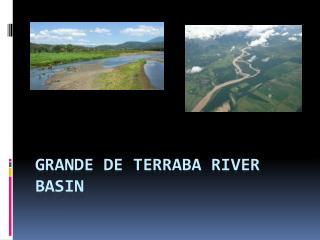
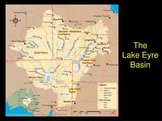
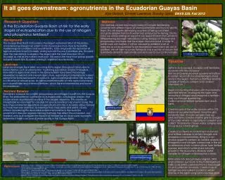
It all goes downstream: agronutrients in the Ecuadorian Guayas Basin Kyle Dietrich, Emmett Lawrence, Dorothy Upton, ENVS 220, Fall 2012 Research Question Is the Ecuadorian Guayas Basin at risk for the early stages of eutrophication due to the use of nitrogen and phosphorus fertilizers? Methods Our methods before reaching Ecuador will include familiarizing ourselves with different types of chemical fertilizers and how to identify them. This will require developing a system of taking consistent, accurate samples from both water and soil sources for testing. On this note, we will be adding an expert to our research team that will aid in differentiating between naturally occurring isotopes of nitrogen and phosphorous and those that have been manufactured. In order to better work with farmers, it will be valuable to establish a set of interview or survey questions to be repeated on each farm we visit. In addition, we will want to survey farmers to find a section of stream that is relatively distant to agricultural sources to use for our control sample. Background The Guayas River Basin in Ecuador is the largest watershed West of the Andes, encompassing a large river system in the Guayas province. Due to favorable meteorological conditions and overall fertility, it has long been the epicenter of agricultural practices in Ecuador, dating back to the pre-Columbian era. Situated near the river delta is Guayaquil, the largest and the most populous city in Ecuador, as well as the nation's main port. This area is the heart that pumps exports out and imports into Ecuador, making it important economically. Guayas Basin Bananas Timeline Land-use Week 1: Settle in Settle in to Guayaquil, Ecuador and familiarize ourselves with the city/area Visit local Guayas province government office to obtain record of documented agricultural lands in the region. Perform a stratified random sample of farms to contact and conduct interviews on. Week 2-10: Interviews Begin conducting interviews with the randomly selected farmers. Investigate the types and amounts of nitrogen and phosphorus fertilizers they use through questioning. Collect soil and fertilizer samples from each farm. Week 10-15: Sampling Create a grid of the water sources within 100 meters of our selected farms. Using the grid, randomly take 10 water samples near our selected farms. Create another grid for a region of the basin where no agriculture is present and collect 10 randomly chosen water samples here to use as our control group. Week 15-20: Water and soil content analysis Conduct a chemical content test on our soil and fertilizer samples to obtain nitrogen and phosphorus concentrations. Bring in a soil analysis expert to perform an isotope analysis of phosphorus and nitrogen compounds in the soil to determine which nutrients come from fertilizer sources, and which nutrients are naturally present in the ecosystem. Analyze water samples for nitrogen and phosphorus levels. Week 20-25: Data Analysis Enter data into data analysis program, SPSS, and compare our results to the Total Maximum Daily Load (TMDL) obtained from a toxicologist at an Ecuadorian University. Create map of fertilizer use and nutrient content in water sources in the basin using GIS to visualize data. Land-use changes have been occurring in this region throughout history due to various factors such as urbanization, increasing population and technological innovation in agriculture. Areas in the Guayas Basin have been increasingly developed to expand and intensify agriculture, responding to international market demand for increased exports of products. Agricultural intensification has resulted in cultivation of annual crops, as well as implementation of new agricultural inputs such as pesticides and chemical fertilizers, which have environmental and social consequences. Nutrient Balance Farmland is a source for nutrient (phosphorous and nitrogen) runoff into the Guayas River. This phenomenon contributes to eutrophication, a biological process that causes anoxic algal blooms resulting in the oxygen depletion. This creates an inhospitable environment for valuable fish species leading to economic losses. The lack of governmental regulations on agricultural activities in Ecuador allows farmers to chose their own practices to maximize their crop yields and profits, usually without considering the associated environmental effects. Because the government does not regulate farming methods that affect the ecosystem, our research aims to investigate the impacts of fertilizer use on local water sources to determine if there is an issue of water quality in the Guayas Basin. Guayas Basin Ecuadorian workers harvesting coffee References 1) Parsons, James J. “Bananas in Ecuador: A New Chapter in the History of Tropical Agriculture.” Economic Geography 33, no. 3 (July 1, 1957): 201–216. doi:10.2307/142308. 2) De Koning, G.H.J, A Veldkamp, and L.O Fresco. “Land Use in Ecuador: a Statistical Analysis at Different Aggregation Levels.” Agriculture, Ecosystems & Environment 70, no. 2–3 (October 29, 1998): 231–247. doi:10.1016/S0167-8809(98)00151-0.3) 3) Miller, E. V. “Agricultural Ecuador.” Geographical Review 49, no. 2 (April 1, 1959): 183–207. doi:10.2307/211984. 4) Southgate, Douglas, and Morris Whitaker. “Promoting Resource Degradation in Latin America: Tropical Deforestation, Soil Erosion, and Coastal Ecosystem Disturbance in Ecuador.” Economic Development and Cultural Change 40, no. 4 (July 1, 1992): 787–807. doi:10.2307/1154634. 5) Smith, Val H. “Eutrophication of Freshwater and Coastal Marine Ecosystems a Global Problem.” Environmental Science and Pollution Research 10, no. 2 (March 1, 2003): 126–139. doi:10.1065/espr2002.12.142.