Severe Weather and Flood Threats: Update for April 25, 2011 – Nashville Area
A significant weather briefing from NWS Nashville outlines the increasing threats of severe weather and flooding through Wednesday, April 27, 2011. Residents are advised of a Flash Flood Watch and severe thunderstorms, particularly in northwest Middle Tennessee. Rainfall totals of 2 to 4 inches may lead to widespread flash flooding, with the highest threat occurring Tuesday night into Wednesday. Stay informed for updates on storm development and safety measures.

Severe Weather and Flood Threats: Update for April 25, 2011 – Nashville Area
E N D
Presentation Transcript
Weather Impacts BriefingApril 25th 2011NWS Nashville*6 To mute your line#6 to unmute your line
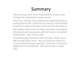
Summary • Significant weather impacts through Wednesday • Severe weather more likely each day • Flood threat continues to increase • Flash Flood Watch late Tuesday through Wednesday • Will outline general threats today and stress specifics on Tuesday’s call
Flood Threat • 2 to 4 inches of rain has already fallen northwest • Stewart, Montgomery and Robertson Counties • Locally heavy rain and flooding possible today, tonight and Tuesday • Highest threat northwest Middle TN • Main flood threat Tuesday Night into Wednesday • Widespread flash flooding possible • Significant rises likely on area rivers
Next 24 Hours • A few strong storms and downpours this morning • Additional storms redevelop this afternoon • Locally severe with heavy rain • Line of storms possible overnight into Tue AM • Highest severe potential west of I-65
Tuesday and Wednesday Impacts • Scattered storms expected to redevelop Tuesday Afternoon – a few could be severe • Widespread storms expected Tuesday night • Some likely severe • Flood threat high • Main cold front comes through Wednesday • Continued high flood threat • Severe weather likely • Supercells
Summary • Significant flood threat – especially from late Tuesday through Wednesday • Slight Risk for severe storms through Tuesday Night • Damaging winds main threat • Isolated tornadoes possible • Moderate Risk for Severe Weather Wednesday • Call at 11 AM Tuesday