Impacts of Lakes and Wetlands on Surface Energy Balance in the Great Lakes Region
This study explores how lakes and wetlands influence the surface energy balance in the Great Lakes area, analyzing their effects on albedo, heat capacity, roughness, and evaporation. Objectives include quantifying impacts and assessing sensitivity to lake depth and area. Results show significant seasonal variations in energy fluxes affected by the presence of lakes and wetlands.

Impacts of Lakes and Wetlands on Surface Energy Balance in the Great Lakes Region
E N D
Presentation Transcript
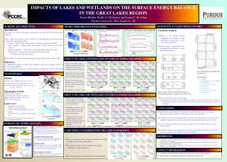
IMPACTS OF LAKES AND WETLANDS ON THE SURFACE ENERGY BALANCE IN THE GREAT LAKES REGION Vimal Mishra, Keith A. Cherkauer and Laura C. Bowling Purdue University, West Lafayette, IN SENSITIVITY TO LAKE DEPTH AND AREA PURPOSE AND OBJECTIVES MODEL PERFORMANCE EVALUATION • Introduction: • The nature of surface-atmosphere interactions are affected by the land surface conditions. • Lakes (open water surfaces) and wetlands are an integral part of that interaction, as they have large differences in: • Albedo – which affects the amount of shortwave radiation absorbed, • Heat capacity – which affects the amount of heat stored at the earth’s surface, • Surface roughness – which affects wind speed and evaporation, and • Evaporation – where lakes and wetlands are unrestricted • in comparison to the land surface. • These differences affect the partitioning of energy fluxes at the earth’s surface. • Objectives: • To quantify the impacts of lakes and wetlands in the surface energy balance of the Great Lakes Region • To understand the sensitivity of energy balance components towards lake depth and area • Climate: • Average winter (DJF) temperature is -25˚C • Average summer (JJA) temperature is 22˚C • Average annual precipitation ranges between • 762 mm – 836 mm. • Topography & Soils: • Glacial features dominate • Low topographic slopes to the south • Higher topographic slopes to the north • Soils: Silt loam and sand • Land Cover : • Northern part is forested • Southern more agricultural • Lakes are prevalent throughout the study • domain • Wetlands are present mostly in the northern • part b. Observed vs simulated stream flow a. VIC vs. MODIS Land Surface Temperature c. Observed vs simulated lake surface temperature Sensitivity Analysis • Most of the energy balance components are sensitive to the fractional coverage area of the lake within a grid cell. • Land surface temperature and ground heat are sensitive to both lake depth and area IMPACT OF LAKES AND WETLANDS ON SURFACE ENERGY BALANCE c a b • First set of figures show • monthly changes in albedo due • to presence of lakes and wetlands between 1917-2007. • Second set of figures show monthly changes in Rnet due to presence of lakes and wetlands • Third set of figures show monthly changes in latent heat (H) due to the presence of lakes and wetlands. • All figures: No Lake – Lake a c c b Fig(7) Sensitivity to lake depth and fractional area For both figures: a- Albedo b- Incoming long wave radiation c- Net radiation d- Net short wave radiation e- Latent heat f- Sensible heat g- Land surface temperature h- Ground heat STUDY REGION a Fig(4) Impact of lakes and wetlands on (a) albedo, (b) net radiation, and (c) latent heat Fig(8) Impacts of lakes and wetlands on domain averaged energy balance components (No lake –lake) IMPACT OF LAKES AND WETLANDS ON SURFACE ENERGY BALANCE a • First set of figures show • monthly changes in sensible heat (SE) due to the presence of lakes and wetlands • Second set of figures show monthly changes in ground heat (G) due to presence of lakes and wetlands • Third set of figures show monthly changes in land surface temperature (LST) due to presence of lakes and wetlands. • All figures: No Lake – Lake • Due to the presence of lakes and wetlands: • Albedo is increased in winter and spring, net radiation is increased in all seasons, latent heat is increased in summer, sensible heat is decreased in summer, and ground heat is increased in summer. b c b CONCLUSIONS • Small lakes and wetlands were included to understand their impacts on regional hydrology and the sensitivity of the energy cycle to their presence. • Spatial structure and temporal patterns associated with lake surface water temperature and lake evaporation were reconstructed for a long term historic period (1917-2007). • Lakes and wetlands reduced land surface temperatures in summer while increasing them in winter. • Sensitivity analysis for a single grid shows that energy balance components are more sensitive to lake area in comparison to the lake depth. • [1] Bowling, L., and D.P. Lettenmaier, Estimating the Freshwater Budget of High-Latitude Land Areas Water Resources Series Technical Reports, October 2002 • [2] Bowling, L.C. and D.P. Lettenmaier, Modeling the effects of lakes and wetlands on the water balance of Arctic environments, Journal of Hydrometeorology, 2008, submitted. • [3] Sinha, T., K. A. Cherkauer and V. Mishra, Historic climate impacts on seasonal soil frost in the Midwestern U.S., Journal of Hydrometeorology, 2008, submitted c Fig(1) (a) Location of lakes, (b) fractional area of lakes and (c) fractional area of wetlands HYDROLOGIC MODEL AND DATA Fig(5) Impact of lakes and wetlands on (a) sensible heat, (b) ground heat, and (c) land surface temperature • Variable Infiltration Capacity (VIC) Model: • Solves full energy and water balance • Accounts for soil freezing and thawing • Simulates lakes and wetlands energy balance using the lake/wetland algorithm [1, 2] • Climate/meteorology forcing: • Gridded precipitation, and daily air temperature extremes for the period of 1915-2007 [3] • Observed Data: • Lake depth-area data from state DNRs, USGS stream flow data and land cover from National Land Cover Dataset (NLCD, 2001) • Lake Depth-Area Profile: • Lake depth-area profiles were estimated using a power function to define a parabolic shape LAKE SURFACE TEMPERATURE AND LAKE EVAPORATION a b REFERENCES • First set of figures show temporal and spatial variability of lake water surface temperature • Second set of figures show temporal and spatial variability of lake evaporation CONTACT INFORMATION • Vimal Mishra, Agricultural & Biological Engineering, Purdue University. E-mail: vmishra@purdue.edu • Project funded by a grant through the NASA Land Cover and Land Use Change program. Fig(6) (a) lake surface water temperature, (b) lake evaporation