Download
1 / 75
750 likes | 986 Views
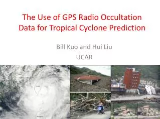
Applications of GPS Radio Occultatoin Data to Tropical Cyclone Prediction. Bill Kuo UCAR COSMIC. Outline. Overview of GPS radio occultation technique and COSMIC Impact on hurricane prediction Genesis of Hurricane Ernesto (2006) Intensity and track prediction of typhoon Shanshan (2006)

E N D
Applications of GPS Radio Occultatoin Data to Tropical Cyclone Prediction Bill Kuo UCAR COSMIC
Outline • Overview of GPS radio occultation technique and COSMIC • Impact on hurricane prediction • Genesis of Hurricane Ernesto (2006) • Intensity and track prediction of typhoon Shanshan (2006) • Comparison of 3D-Var and EnKF • COSMIC-II planning and OSSE study • Ground-based GPS network over the Caribbean
The velocity of GPS relative to LEO must be estimated to ~0.2 mm/sec (velocity of GPS is ~3 km/sec and velocity of LEO is ~7 km/sec) to determine precise temperature profiles
The velocity of GPS relative to LEO must be estimated to ~0.2 mm/sec (20 ppb) to determine precise temperature profiles
COSMIC (Constellation Observing System for Meteorology, Ionosphere and Climate) • 6 Satellites was launched: • 01:40 UTC 15 April 2006 • Three instruments: • GPS receiver, TIP, Tri-band beacon • Weather + Space Weather data • Global observations of: • Pressure, Temperature, Humidity • Refractivity • Ionospheric Electron Density • Ionospheric Scintillation • Demonstrate quasi-operational GPS limb sounding with global • coverage in near-real time • Climate Monitoring A Joint Taiwan-U.S. Mission FORMOSAT-3 in Taiwan
Global FORMOSAT-3 / COSMIC Data Users 1039 users 52 Countries
Presentation of first results from COSMIC/ FORMOSAT-3 to appear in Bulletin of American Meteorological Society, March 2008 Anthes et al.
ECMWF SH T Forecast Improvements from COSMICAssimilation of bending angles above 4 km Sean Healy, ECMWF
ECMWF Operational implementation of GPSRO on Dec 12, 2006 ↑ Neutral in the troposphere, but some improvement in the stratospheric temperature scores. Obvious improvement in time series for operational ECMWF model. Dec 12, 2006 Operational implementation represented a quite conservative use of data. No measurements assimilated below 4 km, no rising occultations. Nov 6, 2007 Operational assimilation of rising and setting occultations down to surface Sean Healy, ECMWF
100 hPa Temperature vs. radiosondes Sean Healy, ECMWF NH tropics SH
NCEP Impact study with COSMIC • 500 hPa geopotential heights anomaly correlation (the higher the better) as a function of forecast day for two different experiments: • PRYnc (assimilation of operational obs ), • PRYc (PRYnc + COSMIC) • Assimilated ~1,000 COSMIC profiles per day • Assimilated operationally at NCEP 1 May 2007 • Assimilating refractivities from rising and setting occultations at all levels (including low level), provided they pass QC • Results with COSMIC “very encouraging” • Lidia Cucurull, JCSDA
UKMO Bias and RMS as function of forecast range mean mean Temp, 250 hPa, SH Wind speed, 100 hPa, SH RMS RMS
Hurrican Ernesto: Formed: 24 August 2006 Reached Hurricane strength: 27 August Dissipated: 1 September 2006 15:50 UTC 27 August 2006 Picture taken by MODIS, 250 m resolution
Forecast experiments • No GPS: initialized from AVN/GFS analysis at 2006-08-23-06Z • GPS all: assimilate all 15 GPS profiles at 2006-08-23-06Z, followed by a 5-day forecast • GPS 1 : only assimilate 1 GPS profile at 2006-08-23-06Z, followed by a 5-day forecast WRF/DART EnKF system 36-km, 36 member ensemble Use non-local excess phase observation operator
Assimilate this sounding only Low-level moisture change by assimilating GPS GPS all GPS 1
2006-08-23-12Z (06h forecast) COSMIC data was critical in prediction the formation and track for Hurricane Ernesto (2006) Assimilate a total of 15 soundings over a 6-h period, and assess their impact on prediction of hurricane genesis Sat. IR No GPS With 15 GPS
2006-08-24-00Z (18h forecast) Sat. IR No GPS GPS all
2006-08-24-12Z (30h forecast) Sat. IR No GPS GPS all
2006-08-25-00Z (42h forecast) Sat. IR No GPS GPS all
2006-08-25-12Z (54h forecast) Sat. IR No GPS GPS all
2006-08-26-00Z (66h forecast) Sat. IR No GPS GPS all
2006-08-26-12Z (78h forecast) Sat. IR No GPS GPS all
2006-08-27-00Z (90h forecast) Sat. IR No GPS GPS all
2006-08-27-12Z (102h forecast) Sat. IR No GPS GPS all
WRF/DART ensemble assimilation of COSMIC GPSRO soundings • WRF/DART ensemble Kalman filter data assimilation system • 36-km, 36-members, 5-day assimilation • Assimilation of 171 COSMIC GPSRO soundings (with nonlocal obs operator, Sokolovskiey et al) plus satellite cloud-drift winds • Independent verification by ~100 dropsondes. 171 COSMIC GPSRO soundings during 21-25 August 2006
No COSMIC With COSMIC 06/8/21 12Z 06/8/22 12Z 06/8/23 12Z 06/8/24 12Z 06/8/25 12Z Genesis of Hurricane Ernesto (2006) Continuous data assimilation during genesis stage with WRF EnKF system
Verification of WRF/DART analysis by about 100 dropsondes during the Ernesto genesis stage.
06/8/21 12Z 06/8/22 12Z 06/8/23 12Z Analysis increment in Q (water vapor) due to the assimilation of COSMIC GPSRO data. 06/8/24 12Z 06/8/25 12Z
No COSMIC With COSMIC 06/8/21 12Z 06/8/22 12Z 06/8/23 12Z 06/8/24 12Z 06/8/25 12Z Genesis of Hurricane Ernesto (2006) Cloud and Rain water Continuous data assimilation during genesis stage with WRF EnKF system
Typhoon Shanshan (Sept 10-17, 2006) Operational forecasts using variational assimilation failed to predict the curving of the typhoon. Central SLP pressure
COSMIC RO soundings (September 13, 2006) RO soundings are randomly distributed over the domain, provide large-scale information.
Assimilation Experiments WRF/DART ensemble assimilation at 45km resolution for 8-14 September 2006. 32 ensemble members. Control/NoGPS run: Assimilate operational datasets including radiosonde, cloud winds, land and ocean surface observations, SATEM thickness, and QuikScat surface winds. •GPS run: Assimilate the above observations + RO refractivity.
Impact of RO Refractivity on Ensemble Forecasts • 16 members • with a finer nested grid of 15km • initialized at 00UTC 13 Sept 2006
Probability forecast of accumulated rainfall (24hours, 12Z 14-15 Sep., > 60mm/day, %) OBS NOGPS GPS Rainfall forecast is enhanced in Northern Taiwan with COSMIC data. This is closer to the observed rainfall.
Ensemble Forecasts of Central Sea Level Pressure NoGPS GPS Ensemble Mean Observed Ensemble mean Observed Intensity is increased with RO data. Ensembles give significance.
Forecast of total column cloud water, 1600Z Sep. 2006 NOGPS GPS The eye and clouds of the typhoon are better forecast with GPS RO data. IR IMAGE
Comparison of WRF 3DVAR and WRF/DART forecast of Shanshan (2006) • Assimilation for 24 hours starting 00Z 13 September 2006 using both 3DVAR and WRF/DART ensemble system • Assimilation of CWB conventional data with/without RO data DARTNBNG: NO GPS run using DART DARTNB: With GPS run suing DART CYCLNBNG: NO GPS run using 3dvar CYCLNB: With GPS run using 3dvar • Followed by a 3-day forecast on 14 September 00Z.
Zonal wind Analysis along the typhoon centers (125.8E) on 00Z 14 September WRF/DART 3DVAR Zonal wind is stronger in WRF/DART analysis
Vorticity Analysis along typhoon centers (125.8E) on 00Z 14 September WRF/DART 3DVAR Vortex is stronger in WRF/DART analysis
Analysis at 00Z 14 Sept 2006 GPS - NO GPS EnKF - 3D-Var
Typhoon intensity (central pressure) 3DVAR WRF/DART OBS
Typhoon track error 3DVAR WRF/DART
Forecast of Integrated Cloud Water at 00Z 16 Sept. 2006 3DVAR IR image WRF/DART