Globally Consistent Leaf Area Index Data from Remote Sensing
This study focuses on deriving a globally consistent record of Leaf Area Index (LAI) using AVHRR, MODIS, Landsat, and VIIRS data. The approach involves ensuring data continuity and consistency across different sensors to monitor vegetation dynamics over multi-decadal periods. The methodology accounts for sensor-specific uncertainties and single scattering albedo to maintain the coherence of LAI estimates. The implementation of this algorithm reflects satisfactory agreement with field data and supports the generation of continuous and globally consistent LAI datasets since the 1970s.

Globally Consistent Leaf Area Index Data from Remote Sensing
E N D
Presentation Transcript
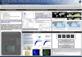
Long-term Data Continuity: A Globally Consistent Leaf Area Index Data Record from AVHRR, MODIS, Landsat and VIIRS Sangram Ganguly1, Ramakrishna R. Nemani1, Weile Wang1, Hirofumi Hashimoto1, Peter Votava1, Andrew Michaelis1, Yuri Knyazikhin2, Arindam Samanta2, Cristina Milesi1, Jennifer L. Dungan1, Forrest S. Melton1 and Ranga B. Myneni2 1NASA Ames Research Center, California/2Department of Geography and Environment, Boston University, Boston, MA. JOINING LAI FROM AVHRR NDVI AND MODIS SURFACE REFLECTANCE Agreement between AVHRR and MODIS C5 LAI Greening trend in 1982-1999 and boreal forest browning trend in 1982-2006 • Consistency conditions for multi-sensor algorithms • the algorithm should generate a set of acceptable solutions given AVHRR NDVI • this set should include all acceptable solutions generated by the MODIS algorithm when given the corresponding AVHRR spectral reflectances; • the algorithm should also be capable of admitting AVHRR spectral reflectances, in addition to NDVI, and generate the same set of acceptable solutions as the MODIS algorithm • Major problems in interpretation of data from multiple sensors are differences in • sampling strategy • spectral band characteristics • spatial resolution of data • uncertainties due to calibration and correction for atmosphere • effects • data information content 1982 - 1999 1982 - 2006 Problem:To develop a physically-based approach for retrieving canopy structure parameters that accounts for the effects of sampling design, measurement accuracy, resolution and information content of data. • Achieving the consistency in NDVI and MODIS LAI is reduced to finding values of sensor-specific measurement uncertainty and single scattering albedo for which • the consistency conditions are met • the retrieval index (RI) is maximized • the difference (RMSE) between AVHRR and MODIS LAI is minimized Our approach is based on the theory of canopy spectral invariants which is parameterized in terms of the single scattering albedo and data uncertainty. The former is an explicit function of the spatial scale and accounts for the spectral band characteristics. The latter accounts for varying data information content. Their correct specification insures consistency in the derived products. The upper panel shows reflectance in the red-NIR plane for a range of LAI and background brightness. Pixels having the same value of Simple Ratio (SM) lie on a line. The ellipse represents measurement uncertainty. The lower panel shows distribution of LAIs corresponding to surface reflectances located (a) in the ellipse (blue points) and (b) lying on the SM line (green points). NASA Terrestrial Ecology Science Team Meeting, 2010 Abstract. The emphasis for NASA’s role in future space missions (e.g. NPOESS) calls for continuous and consistent Earth System Data Records (ESDRs) that are required for quantitatively understanding Earth system processes due to climate and human-induced changes. A key step in assembling long-term data sets is establishing a link between data from earlier sensors (e.g. AVHRR/SeaWiFS) and present/future sensors (e.g. Landsat/MODIS/NPOESS) such that the derived products are independent of sensor characteristics and represent ground reality both in absolute values and variations in time/space. Monitoring and modeling of the terrestrial biosphere within the larger context of climate variability and change studies requires global multi-decadal time series of key variables characteristic of vegetation structure such as the Leaf Area Index (LAI). A physical approach based on the radiative transfer theory of canopy spectral invariants, is used, which facilitates parameterization of the canopy spectral bidirectional reflectance factor (BRF). The methodology permits decoupling of the structural and radiometric components of any optical sensor signal and requires a set of sensor-specific values of configurable parameters, namely the single scattering albedo and uncertainties in surface reflectances for maintaining consistency in retrieved LAI. Implementation of this algorithm to derive an LAI dataset from AVHRR shows satisfactory agreement with the MODIS LAI and field data. The scalable algorithm is currently being utilized in deriving global LAI from Landsat GLS data and its functionality will be extended with the new suite of VIIRS data, thus providing a basis for generating continuous data streams of globally consistent LAI since 1970s. 26 YEAR RECORD OF GLOBAL LAI (JULY 1981 TO DECEMBER 2006) MULTI-SENSOR REMOTE SENSING 70% shows increase in mean peak annual LAI between decade 1 (1981-1990) and decade 2 (1995-2006) Decadal change in mean peak annual precipitation (mm/yr) between decade 1 (1981-1990) and decade 2 (1995-2006) LANDSAT LAI RETRIEVAL INTER-SENSOR PROCESSING ARCHITECTURE Adjustment for spectral/spatial resolution • Theory of canopy spectral invariants based on the physical principles of radiative transfer is used to simulate BRF as a function of LAI, soil reflectances, view angles and land cover type; • Single scattering albedo is a configurable parameter that accounts for differences in spectral resolution and spatial resolution; • Inverse problem is solved using three-band approach. SWIR incorporates additional information about background types (dark vs. bright) – helps to better localize the LAI solution set in case of pixels which may have a higher NDVI but not necessarily higher LAI. AVHRR MODIS LANDSAT VIIRS Localization of LAI in the red/NIR and SWIR is important Integrate the “Ratio” for two different bandwidths corresponding to the red (580-680 nm) and NIR (725-1100 nm) bands. Ratio Red, NIR Red, NIR and SWIR Surface Reflectance Consistency Algorithm accounting for differences in input reflectance uncertainty, spatial resolution and spectral bandwidth LEDAPS Atmospheric Corrections Comparable LAI and dispersion Additional QA showing 2-band (yellow) and 3-band (green) retrievals LANDSAT LAI • References: • Ganguly, S., Samanta, A., Schull, M. A., Shabanov, N. V., Milesi, C., Nemani, R. R., Knyazikhin, Y., and Myneni, R. B., Generating vegetation leaf area index Earth system data record from multiple sensors. Part 2: Implementation, analysis and validation, Remote Sensing of Environment, 2008, 112, 4318–4332, doi:10.1016/j.rse.2008.07.013. • Ganguly, S., Schull, M. A., Samanta, A., Shabanov, N. V., Milesi, C., Nemani, R. R., Knyazikhin, Y., and Myneni, R. B., Generating vegetation leaf area index Earth system data record from multiple sensors. Part 1: Theory, Remote Sensing of Environment, 2008, 112, 4333–4343, doi:10.1016/j.rse.2008.07.014. • Acknowledgements: • This research was funded by NASA Earth Science Enterprise. We • thank Dr. C. J. Tucker of NASA GSFC for making the GIMMS NDVI data available.