Download
1 / 18
180 likes | 327 Views
Introducing UAVs for Atmospheric Chemistry Research. Julie Castellanos Terry Lathem April 25, 2006. Objectives. To describe the use of Unmanned Aerial Vehicles (UAVs) for atmospheric research with emphasis placed on the following: Advantages/Disadvantages of using a UAV platform

E N D
Introducing UAVs for Atmospheric Chemistry Research Julie Castellanos Terry Lathem April 25, 2006
Objectives To describe the use of Unmanned Aerial Vehicles (UAVs) for atmospheric research with emphasis placed on the following: Advantages/Disadvantages of using a UAV platform A review of previous and current missions to demonstrate the effectiveness of using a UAV platform to study the interactions between aerosols, clouds, and pollution. Specifically, we will discuss the use of UAVs to address how pollution affects cloud microphysical and radiative processes (in the context of weather and climate) for both the arctic and tropical regions.
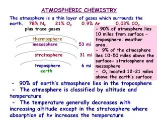
Background Aerosols play a crucial role in the Earth’s radiation balance, yet large uncertainties still exist: in the direct/indirect forcings [IPCC]. Currently, more knowledge about aerosol sources, their distribution, and properties are still needed to reduce these uncertainties. This additional knowledge comes from a more complete and comprehensive data set, which requires measurements at all latitudes, with greater vertical resolution, duration and frequency. IPCC Jacob, 1999
UAVs: A promising solution Current measurement tools are not ideal for obtaining a complete data set in many locations, especially in remote regions of the Tropics and Arctic. UAV’s are an emerging solution which can complement pre-existing measurements (manned aircraft, rockets, satellites, etc). Some key advantages of UAVs include: Remote in-situ sampling • The ability to fly long endurance, optimized missions at a wide range of altitudes and latitudes. • Collect data that is Dull, Dirty, and/or Dangerous
The Current State of the Technology Wide Range of Platforms: Micro to Massive Current sensor technology is rapidly advancing with more optimized and miniaturized sensors being developed for UAV use. With such a wide range of platforms and sensor technology, UAVs can become customized to fit a specific mission plan Currently GT is organizing a NASA based UAV Resource Center for Earth Observations to help researchers and academic institutions customize their missions.
Global Albedo Project (GAP) • Objective: Gather the first long-term, detailed measurements of aerosol/cloud interactions with particular emphasis on the indirect effect. • The indirect effect is acknowledged to be the largest source of uncertainty in understanding the human impact on global climate. • Utilized autonomous UAVs (AUAVs) The skies over the Indian Ocean are frequently polluted by anthropogenic aerosol from South Asia—forming Atmospheric Brown Clouds.
GAP: Data Collection • Dr. Ramanathan led a team of academic and industrial partners to develop specialized AUAVs and instrumentation to obtain aerosol-cloud-solar radiation data in remote regions in the Indian Ocean. • Each AUAV contained an instrument package weighing less than 5kg Movie
Each AUAV tracked a Separate Component of brown cloud formation: 1. The lowest flew beneath the cloud and quantified the input of pollution particles and measured the quantity of light that penetrated the clouds 2. The aircraft flying through the cloud measured the clouds response to the introduction of particles—cloud physics 3. The aircraft flying above the cloud measured the amount of sunlight reflected by the clouds into space and the export of particles out of the cloud. Groupings of 3 AUAVs flew in synchronous vertical formation at 3 critical levels. This allowed for observation of conditions below, inside, and above clouds simultaneously--an unprecedented approach.
GAP/MAC: Results 18 successful data gathering missions were completed in pollution-filled skies near the Malidives following the 3-tier AUAV configuration. Flights took place between March 6 – March 31, 2006 Each AUAV successfully tracked a separate component of brown cloud formation MAC demonstrated that lightweight AUAV’s and their miniaturized instruments are an effective and inexpensive means of simultaneously sampling polluted clouds.
GAP/MAC: Results Data provided by the MAC study allows for parameterizing the aerosol indirect effect over the Indian Ocean. Similar studies in other areas can be used to develop parameterizations of regional indirect effects. • Satellites and surface measurements only give an integrated measure. • UAV studies of this kind have the potential to fill in the gaps on the vertical distribution of pollution Ramanathan et al, 2005: NSF Research Proposal
Motivation for Arctic Research • The impact of clouds on the Arctic radiation balance is poorly understood • Parameters such as cloud base and top height, cloud depth, cloud fraction,and cloud particle shape, size and concentration need to be researched • An additional component in the arctic is the radiative interactions of clouds over reflective surfaces (Intrieri, et. al 1997) • Modeling is difficult because of complex vertical structures with multiple layers, wintertime ice plumes associated with leads, ice crystal precipitation, and the presence of mixed-phase clouds (Morrison, et. al 2003) • The role of pollution in these processes is also not well understood • UAVs provide a way to study this system • Barrow, Alaska • Northern Sweden www.Aerosonde.com
Aerosonde Mission Barrow, Alaska • Objective: To obtain atmospheric chemistry measurements in support of LEADX, an international collaboration involving more than 25 researchers from 8 different organizations • Platform specifications • Wingspan:10 feet • Weight: 30 pounds • Range: 1800 miles • Endurance: >30 h • Altitude: 20,000 ft • Instruments used • Ozone sensor • Mercury sensor • Hand Held Particle Counter • Meteorological • Video Ice Particle Sampler (VIPS)
Aerosonde: VIPS • Aerosols act as cloud condensation nuclei • In the arctic, they also serve as ice condensation nuclei • In order to understand the radiative properties of clouds, it is necessary to understand the optical properties • Particle habit • Size distribution • VIPS instrument • Video of ice particles collected during flight • Images are processed to determine the optical properties of arctic clouds • Allow intercomparison between clean and polluted environments and effects on cloud optical and radiative properties
Swedish Space Corporation Mission Northern Sweden • Objective: To measure the vertical and horizontal variability of particle concentrations in the North Atlantic Aerospace Test Range (NEAT) using the Eagle UAV • Platform Specifications • Wingspan:56 feet • Weight: 2450 pounds • Endurance: 24 h • Altitude: 33,000 ft • Payload 550 lbs • Instruments used • TSI Condensation Particle Counter • Counts sub micrometer particles continuously, up to 10000 particles/cm3 Abrahamsson, et. al.
Swedish Space Corporation Mission: Method and Results Abrahamsson, et.al • UAV flew in a saw-tooth manner between the altitudes of 13,000 and 25,000 feet • Four tracks were flown north-south • Flew in lower layer to measure the horizontal variation within it • Results • Two different aerosol layers were detected • 14,000 feet and 20,000 feet • Advantage: The data was relayed to the scientist on the ground who could then control the UAV and guide it within the layers as needed
Conclusions UAVs are an emerging technology for Atmospheric and Earth Science applications Data gathered by these platforms have higher vertical resolution, and the ability to sample at increased frequency and duration—significantly reducing the “gaps” of scientific knowledge in climatologically important regions. In order for UAVs to become more credible in the eyes of the scientific community, more ground-breaking studies are needed to demonstrate the effectiveness of UAVs in performing research that was previously inaccessible. FAA regulations are currently strict, which severely limits the current applications of UAVs in urbanized areas, but as the technology continues to grow, one day they may become as routine as pre-existing measurement techniques.
References Abrahamsson, M, et al. UAVs for Atmospheric Research in the North of Sweden, 2002. Curry, J.A, et al. Applications of Aerosondes in the Arctic. American Meteorological Society, BAMS, 2004 Curry, J.A, et al. Overview of Arctic Cloud and Radiation Characteristics. Journal of Climate. Vol. 9, No. 8, 1996 Holland, G.J, et al. The Aerosonde Robotic Aircraft: A new Paradigm for Environmental Observations. Bulletin of the American Meteorological Society, Vol 82, No. 5, 2001 Jacobs, Daniel. Introduction to Atmospheric Chemistry. Princeton University Press, 1999. Ramanathan V, et al. Maldives AUAV Campaing (MAC). NSF Proposal, 2005. Ramanathan V, et al. Development of a Long Range and Light weight Autonomous Unmanned Aerial Vehicle (AUAV) and instrument platform for the Global Albedo Project (GAP). NSF Proposal, 2003. Wegener, S, eta al. UAV Autonomous Operations for Airborne Science Missions. American Institute of Aeronautics and Astronautics, 2004. Williams, Robyn (2005) Studies of Mixed Phase Cloud Microphysics using an In-situ Unmanned Aerial Vehicle Platform. Zulaf, M.A. and Krueger S.K. (2003) Two-dimensional numerical simulations of Arctic leads: Plume penetration height. Journal of geophysical research. 108, 8050.
Additional Web Resources Scripps Institution of Oceanography: http://www.scripps.ucsd.edu http://www-ramanathan.ucsd.edu/fieldcampaigns.html http://www-c4.ucsd.edu/gap/ http://www-abc-asia.ucsd.edu/MAC/secure/Index.htm Aerosonde http://www.aerosonde.com IPCC: http://www.ipcc.ch/pub/un/syreng/spm.pdf