1. Introduction
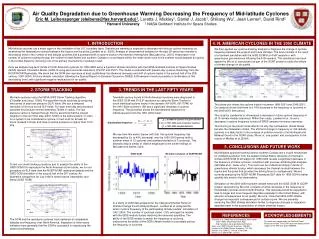
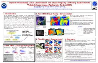
New VIIRS. MODIS. Single Layer Thin Cirrus. Thin Cirrus Overlapping Low Cloud. Thicker Cirrus Overlapping Lower Cloud. “Validation”. NEW VIIRS. MODIS. A schematic illustration of GMCAT. Note the multi-algorithm processing capability. Low Cloud. Cirrus Overlapping Low Cloud. Thin Cirrus.

1. Introduction
E N D
Presentation Transcript
New VIIRS MODIS Single Layer Thin Cirrus Thin Cirrus Overlapping Low Cloud Thicker Cirrus Overlapping Lower Cloud “Validation” NEW VIIRS MODIS A schematic illustration of GMCAT. Note the multi-algorithm processing capability. Low Cloud Cirrus Overlapping Low Cloud Thin Cirrus Bulk cloud phase (day/night) Thin cirrus identification (day) Thin cirrus identification (night) Bulk cloud phase (day) Volcanic Cloud Low Cloud Multilayered cloud Detection (day) Multilayered cloud Detection (night) A43B-0077 Improved Automated Cloud Classification and Cloud Property Continuity Studies for the Visible/Infrared Imager/Radiometer Suite (VIIRS) Michael J. Pavolonis*, Andrew K. Heidinger*, and Keith Hutchison# *NOAA/NESDIS Center for Satellite Applications and Research - Madison, WI #The University of Texas at Austin, Center for Space Research; Northrop Grumman Corp., Space Technology 1. Introduction 3. New VIIRS Cloud Typing - Demonstration Daytime A new automated cloud typing algorithm for the Visible/Infrared Imager/Radiometer Suite (VIIRS) is presented. The new algorithm, which is a part of the Integrated Data Processing System (IDPS), builds upon the heritage Advanced Very High Resolution Radiometer (AVHRR) and Moderate Resolution Imaging Spectroradiometer (MODIS) operational cloud-top phase algorithms. This poster will highlight the VIIRS cloud typing algorithm enhancements such as multilayered cloud detection. Further, in order to compare various VIIRS cloud algorithms to heritage AVHRR and MODIS algorithms on a global basis, a processing system called the Global Multi-imager Cloud Algorithm Testbed (GMCAT) was developed. In this poster, GMCAT is used to illustrate the cloud typing algorithm enhancements and some preliminary cloud top temperature/emissivity comparisons are shown. • Many thin cirrus clouds are called “ambiguous” by MODIS, but are correctly identified by the VIIRS algorithm. • Knowledge of multilayered clouds can help in the development of more advanced cloud property retrieval algorithms. • Certain multilayered clouds tend to be called mixed or ambiguous by MODIS. • Note, the MODIS Team has recently developed an overlap detection method and an improved daytime phase algorithm; however, neither are part of the operational cloud phase product at this time. • Comparisons with ground-based instruments show that the VIIIRS algorithm improves upon the heritage AVHRR algorithm. • MODIS comparisons will be added in the future. Nighttime • The VIIRS algorithm is able to identify most of the multilayered cloud in this scene. • MODIS returns ambiguous when thin cirrus overlaps low cloud. 4. Cloud Property Comparisons 5. Summary • The new VIIRS cloud typing algorithm presented here is unique in that thin cirrus and multilayered clouds can be accurately identified. • Thin cirrus clouds and certain multilayered clouds tend to be classified as mixed and ambiguous by the heritage MODIS cloud phase algorithm, but are often correctly classified by the new VIIRS algorithm. • A new MODIS processing tool was developed to aid in the comparison of various VIIRS cloud property algorithms with heritage MODIS and AVHRR algorithms. Several detailed comparisons will be performed in the future. • References: • Pavolonis, M. J., A. K. Heidinger, and T. Uttal, 2005: Daytime global cloud typing from AVHRR and VIIRS: Algorithm description, validation, and comparisons. J. Appl. Meteor., 44, 804-826. • Pavolonis, M. J., and A. K. Heidinger, 2004: Daytime cloud overlap detection from AVHRR and VIIRS. J. Appl. Meteor., 43 (5), 762-778. • Pavolonis, M. J. and A. K. Heidinger, 2005: Advancements in identifying cirrus and multilayered cloud systems from operational satellite imagers at night. International Asia-Pacific Environmental Remote Sensing Symposium, 4th: Remote Sensing of the Atmosphere, Ocean, Environment, and Space, Honolulu, Hawaii, 8-11 November 2004. Applications with Weather Satellites II (proceedings). International Society for Optical Engineering, (SPIE), Bellingham, WA, 2005, pp.225-234. • Heidinger, A. K., and M. J. Pavolonis, 2005: Global daytime distribution of overlapping cloud from NOAA's Advanced Very High Resolution Radiometer. J. Climate, 18 (22), 4772-4784. AVHRR MODIS 2. New VIIRS Cloud Typing Algorithm The GMCAT tool allows us to compare various cloud property algorithms including cloud top temperature and emissivity. In this example, the heritage AVHRR algorithm is shown on the left and the MODIS CO2 slicing technique is on the right. Since the VIIRS will not have CO2 absorption channels, the AVHRR algorithm is a reasonable representation of the VIIRS capability for this product. As expected, this simple comparison illustrates that the biggest differences are associated with thin high clouds. • Algorithm Classifies Clouds as: • Liquid water • Supercooled water/mixed • Opaque Ice • Cirrus • Multilayered Contact the author at Mike.Pavolonis@noaa.gov