Topo Maps
Topo Maps. Map Projections. All projections contain distortion except along the intersection of the map projection plane with the Earth’s surface Map projections are developed to preserve one of four characteristics Scale (distance measurements) Shape (geographical representations)

Topo Maps
E N D
Presentation Transcript
Map Projections • All projections contain distortion except along the intersection of the map projection plane with the Earth’s surface • Map projections are developed to preserve one of four characteristics • Scale (distance measurements) • Shape (geographical representations) • Direction (navigation) • Area (Agricultural estimates) • Important to use the map projection that best suits your needs • Mercator, Universal Transverse Mercator (UTM), Polar Stereographic
Map Scales • Ratio of distance on map to distance on Earths surface • 1:24,000 scale (1” on map = 24,000” on ground) • The larger the number the smaller the scale • 1:24,000 • 7.5 min map • Covers 7.5 min of lat/lon • Most used type of topo map
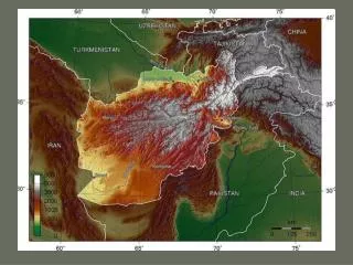
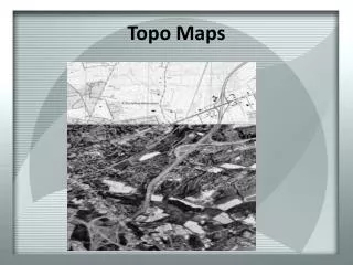
Topo Maps • Flat representation of the Earth’s 3-dimensional surface • Use symbols to define locations and types of features • Mark grids of several different coordinate systems
Map Parameters • Quad name and location • Upper and lower right corners • Location relative to state outline • Names of adjacent quads • Scale and contour interval • Bottom center • Scale bars in km and mi • Note subdivisions for refining distance estimates • Projection and datum • Lower left corner or center
Coordinate Systems • Latitude/Longitude • Degrees/minutes/seconds • 360/60/60 • 7.5 mins square • Tic marks every 2.5mins • Universal Transverse Mercator (UTM) • Measured in meters from equator and prime meridian • Northing and easting • Tic marks every 1000 meters • Township and Range (36mi2) • In red on border • T20S = township 20 south • R15E = range 15 east • 6x6 square miles numbered sections (1-36) • Subdivide by quarters reading backwards
Contour Lines • A succession of points defining a line of equal elevation above a datum (usually Mean Sea Level-MSL) • Must eventually close • Never cross • Contour interval • Elevation change between two adjacent lines • Heavier lines at 100 divisions • Interpretations • Rise over run • Steeper = closer together • Flatter = farther apart • Law of the V’s • Contour lines V upstream or upslope • Depressions are hatched • Feet vs meters