TOPO Mapping S/W
TOPO Mapping S/W. National Geographic Topo!. Objectives. To be fucnctional with Topo on a SAR you should learn to: Open & save Topo (Olympic Region & any .tpo/.tpg files associated with a mission Move around the map (pan, zoom, magnify) Manage Wayoints (create, locate, edit, delete, label)

TOPO Mapping S/W
E N D
Presentation Transcript
TOPO Mapping S/W National Geographic Topo!
Objectives • To be fucnctional with Topo on a SAR you should learn to: • Open & save Topo (Olympic Region & any .tpo/.tpg files associated with a mission • Move around the map (pan, zoom, magnify) • Manage Wayoints (create, locate, edit, delete, label) • Print & export maps (of the area of interest) • Measure directions & distances (to features & between waypoints) • Create routes (to measure distance, build profiles) • Access map info (pub dates, datum, legend info)
Overview • Interface • Menus • Displays • Waypoints & grids • Printing • Copying & exporting maps • Measuring direction & distance
Overview • Topo file types and saving files • Searching and moving in Topo • Routes & Profiles • Map info & legends • Summary ( what you need to know)
Pop-up Option Menus • Many of TOPO!’s most important features, like elevation profiling, can only be accessed from pop-up option menus. All objects that you add to maps (routes, waypoints, direction lines, symbols and text labels) contain pop-up menus that provide options. These menus can be accessed by placing your cursor over an object.
Pop-up Option Menus • Tip: Waypoints and GPS routes can only be edited or activated when you are using the Waypoint Tool. To pop-up an option menu on a waypoint, be sure you are using the Waypoint Tool.
Using the Status Bar • The status bar running along the bottom of the TOPO! window provides real-time help and information.
Waypoints and Grids • Reading coordinates in TOPO!: • Look in the lower right corner of the status bar to find coordinate information. By default, coordinates are displayed in degrees, minutes, seconds using the latitude / longitude coordinate system. The default datum is the North American Datum of 1983 (NAD83). This datum is essentially equivalent to WGS84, used by most GPS receivers
Waypoints and Grids • Placing a New Waypoint: • 1. Choose Waypoint from the Tool menu. • 2. Move the cursor to the point on the map you wish to mark. (Note: As you move the cursor, its coordinates are displayed in the bottom right corner of your screen.) • 3. Left click to place a Waypoint. • Once you have placed the point, the TOPO! Waypoint Editor will appear onscreen. The Editor can be used to name the current waypoint (TOPO! will number them sequentially by default)
Waypoints and Grids • Moving and Editing Waypoints • Waypoints can be moved them on the map. If you want to edit a waypoint's coordinates, name, or elevation, open its Waypoint Editor: • 1. Choose Waypoint from the Tool menu. • 2. Position your cursor over the waypoint and right-click to access the pop-up option menu. • 3. Select Properties… from the pop-up option menu. • 4. This will open the Waypoint Editor, where you can edit the waypoint's properties. • 5. Click OK to apply any changes you've made to the waypoint.
Waypoints and Grids • Using Grids • Grid lines on a printed map allow you to easily identify your position when you obtain your coordinates from a GPS receiver. TOPO! can provide either latitude/longitude or UTM coordinate reference data, scaled to your specifications. Once activated, your grid lines will automatically appear on printed maps.
Waypoints and Grids • To add grid lines to any map: • 1. Select Grid… from the View menu. The TOPO! Grid Wizard will appear. • 2. Use the Grid Wizard to Choose a grid type (Lat/Long or UTM) and interval (in seconds or meters, accordingly). • 3. Next, Specify the map level that should display this grid. • 4. Finally, Pick a color for the grid lines. You may also specify solid or dashed lines. • 5. Click Finish to apply the grid lines to your map.
Waypoints and Grids • Saving GPS Data to the Hard Drive – .tpg Documents Like .tpo files, .tpg files allow you to save and organize different sets of custom data. But whereas .tpo files contain route, symbol, text, and bookmark information, .tpg files are concerned exclusively with preserving GPS waypoint and route data
Waypoints and Grids • Saving GPS waypoints and/or GPS routes • From the File menu, select Save (.tpg) File or Save (.tpg) File As... This will save all your current waypoints and routes in a .tpg file for later reference. • Open (.tpg) File… from the File menu.
Quick Guide to Printing • Most of the maps in TOPO! are much larger than a printed page. The Print Tool allows you to easily define a page-sized area of map for printing or copying to the clipboard. To print a map from TOPO!, do the following:
Quick Guide to Printing • 1. Choose Print from the Tool menu. A red rectangle with an “X” through its center will appear on the map. This rectangle shows the current Selection Area; its size defaults to the amount of map that will exactly fit on the printed page.
Quick Guide to Printing • 2. Left click on the map at the center of the area you wish to print. (You can also drag the Selection Area rectangle around on the map to adjust the print boundaries). • 3. Click the Print Map button at the lower right portion of the screen.
Printing Maps • Selecting an Area of Map to Print • When you select the Print Tool, a red rectangle with an “X” through its center will appear on the map. This rectangle shows the current Selection Area: its size defaults to the amo unt of map that will exactly fit on the printed page. This is indicated by a checked box called Select 1 Full Page that appears in the print options at the right side of the screen. To print a full page map, make sure this box is checked. The selection area can be moved by clicking on a new center point on the map or grabbing and dragging a side
Printing Maps • Printing less than one full page • 1. Un-check the “Select 1 Full Page” box found on the right side of your screen among the Print Options. • 2. Redraw the Selection Area to your specifications by placing the cursor at one corner of the desired area and holding down the left mouse button while dragging the mouse to draw a new rectangle.
Printing Maps • Using the Print Preview Pane • The Print Preview pane lets you review the boundaries of the Selection Area before you print. Once you have defined your Selection Area, refer to the Print Preview pane in the upper right corner of your screen. The red rectangle and “X” represent the portion of map that will be printed. The white rectangle background represents the sheet of paper in the current printer
Printing Maps • To Review the Boundaries of the Selection Area • 1. The dark blue rectangle in the Print Preview pane indicates the portion of the Selection Area currently in view on-screen. • 2. Move the cursor within the Print Preview pane. A light blue rectangle and targeting circle will appear. • 3. Left-click to center the main-screen map display on the point indicated by the light-blue targeting circle. Target the boundaries of your Selection Area to confirm that the selected area is what you want to print.
Printing Maps • Adjusting the Magnification of the Printed Map • To increase the magnification of the map, click the Custom... magnification button, then enter a scaling factor of 75%, 100 %, or even larger. To reduce the magnification of the map, click the Custom... magnification button, then enter a scaling factor of 40% or even smaller. To get an exact area defined on the map to expand or shrink to fit a page, click the Custom... magnification button, then choose Magnify or reduce selected map to exactly fit 1 page.
Printing Maps • Including Headers, Elevation Profiles and other Reference Data • The Include section in the lower right corner of the Print Options pane allows you to choose the marginalia that will be printed around the borders of your map. • Scale Bar box to include a distance scale reference bar in your print. • North Arrow will place an indicator on your print identifying both true and magnetic north. • Grid Labels option will print the latitude and longitude or UTM coordinates of the grid lines
Copying Maps • Copying and Exporting Maps • Individual map selections can be copied and pasted into other applications, or exported to disk for use in other programs. Copying a map to the clipboard • 1. Define your Selection Area using the Print Tool • 2. Choose Copy Map from the File menu to copy the current Selection Area to your computer’s clipboard. The map can then be pasted into documents, graphics files, etc
Exporting maps • 1. Define your Selection Area using the Print Tool • 2. Choose Export Map to Disk… from the File menu to save the current Selection Area. • You will have the option to specify the graphics file format in which you would like the map saved (i.e.: .bmp, .jpeg, .gif, .tiff, etc.)
Measuring Direction • Use the Compass Tool to measure direction and distance between any two points. • TOPO! can display directions relative to True North or relative to the magnetic north pole • You can toggle between these two modes via the Preferences menu
Measuring Direction • The Compass Tool can be used in two different modes. Radial Mode is useful when you want to measure the direction from one location on the map to several other locations. The anchor point will remain fixed at point A when a direction line is created from point A to point B. Waypoint Mode is useful when you want to measure a series of directions along a zig zagging route • You can toggle between these two modes via the Preferences menu
Measuring Direction • To measure direction from an anchor point to your cursor • 1. Choose Compass from the Tool menu. • 2. Position the cursor where you would like to place an anchor point • 3. Left click to place an anchor point • Once you have placed an anchor point on the map, TOPO! displays the direction and distance from the anchor point to your cursor in the status bar. TOPO! updates the display as you move your cursor.
Measuring Direction • Once you place an anchor point, you can move to nearby locations with the traveling cursor at the edge of the map or to distant locations on the overview maps. You can also switch map levels by right clicking on the map and your anchor point will remain fixed at its location.
Measuring Direction • To draw a direction line between two points • 1. Left click the Compass Tool button on your toolbar or choose Compass from the Tools menu • 2. Position the anchor cursor where you would like the direction line to start • 3. Left click to place the anchor point • 4. Left click again at the position where you would like the direction line to end • 5. TOPO! will draw a direction line between the two points
Measuring Direction • To draw a direction line between two points • 6. To reposition the anchor point, left click the anchor on the map or the compass tool button on the toolbar After drawing a direction line, TOPO! will display the line distance and azimuth in a pop-up text box and on the status bar when you place the cursor over the direction line.
Measuring Direction Placing an Anchor Point on Top of Other Custom Objects • You can place an anchor point on top of other routes, symbols, text labels or direction lines without selecting the custom object below. • 1. Choose Compass from the Tool menu. • 2. Hold down the “Ctrl” key. • 3. Move the cursor over the object and place the anchor for the direction line. • 4. Release the “Ctrl” key.
Managing your Maps and Saving your Work • Opening and Saving .tpo Documents • When you start TOPO! by double clicking the TOPO! icon, the program asks you to open a region (.tpo)document. Ours is: OLYMPICS.TPO
Managing your Maps and Saving your Work • It is also where TOPO! stores any custom information you may have added to a map, such as routes, symbols, text labels, and bookmarks. (But not GPS waypoint & route info, see .tpg)
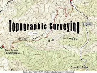
Navigating and Searching the Maps • TOPO!’s maps can be navigated in many ways. You can zoom in or out to see different levels of map detail, scroll across map boundaries, and jump instantly to any location for which you know the name or coordinate.
Navigating and Searching the Maps • To zoom using the Zoom Tool: • 1. Choose Zoom from the Tool menu. • 2. Position the magnifying cursor where you want to zoom in. • 3. Left click to zoom in one level.
Navigating and Searching the Maps • To scroll the map with the Traveling Tool: • 1. Choose Traveling from the Tool menu, or simply position the cursor near the edge of the map • when using another tool. • 2. Position the arrow cursor in the direction you want to move. • 3. Hold the left mouse button down to begin traveling. • 4. Release the mouse button to stop traveling.
Navigating and Searching the Maps • The Centering Tool will bring any location to the center of your screen. • To use the Centering Tool: • 1. Choose Centering from the Tool menu. • 2. Position the cursor on the map. • 3. Left click to center the cursor’s location.
Navigating and Searching the Maps • To navigate using the Overview Maps: • 1. Place your cursor over the Overview Maps on the right side of the screen • 2. A light blue rectangle will appear in place of your cursor. The dark blue rectangle represents the area currently on display • 3. Position the light blue rectangle over the area of map you wish to jump to • 4. Left click to jump to the light blue rectangle’s location.
Navigating and Searching the Maps • Tip: If you are viewing USGS 7.5’ quad maps, TOPO! displays an overview map that shows a thumbnail of the entire 7.5’ quad you are viewing as well as the quad’s name. Use the bottom overview map to jump to a different USGS quad map in the region.
Navigating and Searching the Maps • To search for a named location: • 1. Choose Find (Gazetteer) from the View menu. • 2. Choose List All Features from the search dialog box. (To narrow your search, choose List Only • Features of Type and choose a specific feature such as “Summit” or “Lake” to search by.) • 3. Begin typing the first few letters of the location you are looking for.
Navigating and Searching the Maps • To search for a named location: • 4. Click on an entry in the list to preview its location on a small overview map. • 5. To jump to the selected location, click the Go button. • 6. The location you selected will appear at the center of your screen at the intersection of the red cross hairs.
Navigating and Searching the Maps • The Coordinate Locator will find a given latitude and longitude or UTM location on the map. • To search for a coordinate: • 1. From the View menu, choose Coordinate Locator or left click the coordinate display in the lower right corner of the status bar. • 2. Use the keyboard to enter the latitude and longitude or UTM values of the position you want to find. • 3. Choose the map level that you want to view the position on.
Navigating and Searching the Maps • 4. Click the Go button to jump to that position on the map. • 5. The position you entered will appear at the center of your screen at the intersection of the red cross hairs.
Navigating and Searching the Maps • The Coordinate Locator can also be used to measure direction and distance between a location on the map and a coordinate value entered into the coordinate locator. • place an anchor point on a bridge and enter the coordinates of a summit, and the Coordinate Locator will report the direction and distance between the two locations.
Navigating and Searching the Maps • To determine the direction and distance to a distant landmark’s location: • 1. Use the Compass Tool to place an anchor point on the map • 2. Choose Coordinate Locator from the View menu. • 3. Enter the latitude and longitude or UTM value for the desired destination point. • 4. TOPO! will display the distance and direction from the anchor point to the new coordinate in the Coordinate Locator window.
Navigating and Searching the Maps • Tip: The coordinate locator will measure direction and distance from a point on the map to coordinates that are outside of the area of coverage. This can be useful for determining which direction to look to view distant landmarks, such as summits
Creating and Using Routes • The Route Tool is essential for measuring distance, customizing maps, building elevation profiles and creating GPS routes.
Creating and Using Routes • Drawing a Route • 1. Choose Route from the Tool menu. • 2. Position the cursor over the map where you want the route to begin. • 3. Left-click and release the mouse to begin drawing a new route. (The pencil cursor will change from horizontal to an upright position to indicate that you are in drawing mode.) • 4. When your route is complete, left-click to stop drawing.
Creating and Using Routes • For straight line segments • 1. Hold down the shift key while drawing to start a straight segment. The pencil cursor icon will be replaced by a targeting cursor. • 2. Position the targeting cursor where you would like to end the straight line segment. (If you position the cursor at the edge of the screen, the map will scroll automatically) • 3. Release the shift key to end the line segment