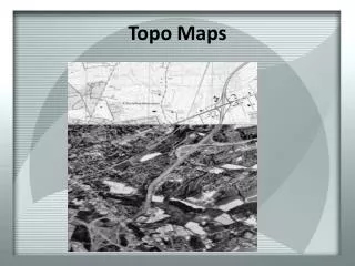
Topo Map Familiarization
Topo Map Familiarization. Training On Demand. What is a Topographic Map. A topographical map is a representation of the Earth, or part of it. The distinctive characteristic of a topographic map is that the shape of the Earth's surface is shown by contour lines.

Topo Map Familiarization
E N D
Presentation Transcript
Topo Map Familiarization Training On Demand
What is a Topographic Map • A topographical map is a representation of the Earth, or part of it. • The distinctive characteristic of a topographic map is that the shape of the Earth's surface is shown by contour lines. • Contours are imaginary lines that join points of equal elevation on the surface of the land above or below a reference surface such as mean sea level. • Contours make it possible to measure the height of mountains, depths of the ocean bottom, and steepness of slopes.
What is a Topographic Map cont. • A topographic map shows more than contours. • Maps includes symbols that represent such features as streets, buildings, streams, and woods. • These symbols are constantly refined to better relate to the features they represent. • A topographic map tells you where things are and how to get to them. • In our case, they assist with the location and verification of wildland fires. • They show the distance between any two places, and they also show the direction from one point to another.
Distances: How far is that? • Maps are made to scale; that is, there is a direct relationship, between a unit of measurement on the map and the actual distance on the ground. • If 1 inch on the map represents 1 mile (which converts to 63,360 inches) on the ground, the map's scale is 1:63,360. • A convenient way of representing map distance is by the use of a graphic scale bar. • Most USGS topographic maps have scale bars in the map margin that represents distances on the map in miles, feet, and kilometers.
Map Legend Info • Scale indicates 1:24ooo • Map is complete with scale bar to measure distance • Contour interval as indicated is 40 ft.
Contour: How High is that? • Contour lines are a method of depicting the 3-dimensional character of the terrain on a 2-dimensional map. • Contour are lines drawn on the map represent equal points of height above sea level. • On multi-colored maps, contour lines are generally represented in brown. • The map legend will indicate the contour interval—the distance in feet (meters, etc.) between each contour line. • There will be heavier contour lines every 4th> or 5th contour line that are labeled with the elevation
Contour How High is that cont. • Contour maps give us the grounds topography by the way the lines interact with each other as seen here.
Other General Map References Black - man-made items Blue - water Brown - contour lines Green - substantial vegetation White - little or no vegetation Red- major highways Purple - features added to the map since the original survey.
Practical Map Usage • Topo maps are used for two main purposes in the fire service: Triangulate the location/ boundaries of a fire Or Identify the location of fire resources in the field • Both operations require the use a way to gauge location • Latitude/Longitude or the Public Land Survey System defines locations on a map • Both require useful knowledge of compass operation.
What Is Public Land Survey System? • The Public Land Survey System (PLSS) is a way of subdividing and describing land in the United States. • All lands in the public domain are subject to subdivision by this rectangular system of surveys, which is regulated by the U.S. Department of the Interior • The PLSS is used to divide public domain lands, which are lands owned by the Federal government for the benefit of the citizens of the United States. • The original public domain included the land ceded to the Federal Government by the thirteen original States, • It encompasses major portions of the land area of 30 southern and western States. • Since the original PLSS surveys were completed, much of the land that was originally part of the public domain has been transferred to private ownership.
Public Land States • Alabama • Alaska • Arizona • Arkansas • California • Colorado • Florida • Idaho • Illinois • Indiana • Iowa • Kansas • Louisiana • Michigan • Minnesota • Mississippi • Missouri • Montana • Nebraska • Nevada • New Mexico • North Dakota • Oklahoma • Ohio • Oregon • South Dakota • Utah • Washington • Wisconsin • Wyoming
How PLSS works • Land is divided into 6-mile-square townships, which is the level of information included in the National Atlas. • Townships are subdivided into 36 one-mile- square sections. Sections can be further subdivided into quarter sections, quarter-quarter sections, or irregular government lots. • Most PLSS surveys begin at an initial point, and townships are surveyed north, south, east, and west from that point. • This line is perpendicular to the Principal Meridian.
Township and Ranges • Township N S • Range E W • Each 6 miles squares • Fire in T3N R2E
Sections • 1 mile square • 640 acres • Numbered within Township/Range
Section Subdivisions • ½ Sections, ¼ Sections divide the section number further • Identified by cardinal direction location • Ie. “SW ¼ of Section 10”.
How does this Apply to me? • Fires are now most often located by Latitudinal and Longitudinal coordinates • Devices utilizing satellites easily gather coordinates for easy reference • Devices must be set to DATUM NAD83 to provide to correct information • PLSS acts as a secondary way of indicating the location of a wildland fire. • PLSS will make conversion to Latitude and Longitude easy • By identifying a fire’s location it can be determined who must be notified
Triangulating a Fire • Triangulation has become a generic term for the process of measuring to two or more known points to determine - using geometry - the location of an unknown point.
Compass Triangulation • To map a fire, firefighters should always triangulate to insure the most accurate possible idea. • Align the base plate with an imaginary line between two points on the map. • Turn the compass dial until the north lines align with the north lines on the map. • Read the bearing set on the compass dial.
Taking a bearing to an object • Hold the compass flat. • Sight from an object you can identify on the map • Move the dial to match north • Remember to account for magnetic declination • Read and document the bearing • Move to your next landmark
Magnetic Declination • Grid North • Where the grid on your map is pointing. Since grid lines on the map are all parallel, they never meet in one point. • Magnetic North • Where the magnetic needle points. These wavy lines depend on iron magma in the earth that changes each year • According to the NOAA Frisco CO has a 9⁰ E Magnetic Declination in 2012 • 9°E means we rotate the base plate's orienting arrow 9° E of 0°/N to compensate for the +9° declination • Not a big deal when we are close, but over distance it can lead to significant inaccuracies. • Topo maps should indicate a declination chart on them
Plotting bearings on a map • Set the bearing on the compass dial. • Lay the long edge of the compass on the known point (where the bearing was taken from). • Turn the compass plate so that the north lines align with the north lines on the map.
Taking bearings off a map • Align the base plate with an imaginary line between two points on the map. • Turn the compass dial until the north lines align with the north lines on the map. • Read the bearing set on the compass dial. • Be aware then of magnetic declination and whether your compass is measuring magnetic north or has been adjusted to grid north.
Conclusion • Topo maps and navigation for the purpose of locating wildland fires is not difficult. • However, it is a skill that needs to be practiced on a frequent basis to remain proficient • Utilize what you have learned and practice your skills • Once you are re-familiarized with finding bearings on a map, you will remember how triangulation works • Practice these skills as a company