Download
1 / 25
250 likes | 352 Views
Weekly Weather Briefing “Few Thunderstorms Tuesday, Winds Wednesday” NWS Albuquerque March 24, 2014. New NOWData Tab. The entire period of record will now be available. Previously, data only available a few years. Data from supplemental sites like RAWS and CoCoRaHS now included.

E N D
Weekly Weather Briefing “Few Thunderstorms Tuesday,Winds Wednesday” NWS Albuquerque March 24, 2014
New NOWData Tab • The entire period of record will now be available. Previously, data only available a few years. • Data from supplemental sites like RAWS and CoCoRaHS now included.
Near to Below Normal Temps Most of Week Tuesday warmest day of the week for central/western areas. Tuesday, March 25TH Friday, March 28th
Winds at a Glance WED SUN THU Surface to 10kft Mean Wind Speed (kts) TUE MON FRI SAT
Upper Level Forecast Chart(Image is Moisture) Tonight Tonight: No concerns tonight as dry northwest flow aloft dominates.
Upper Level Forecast Chart(Image is Moisture) Tuesday Tuesday: Weak system over southern Arizona approaches western NM late in the day and draws moisture northward. Increasing potential for scattered showers and a few thunderstorms during the afternoon into Tuesday night. Focus western and southern areas.
Upper Level Forecast Chart(Image is Moisture) Wednesday Wednesday: Westerly flow aloft increases along with Pacific moisture. Windy conditions expand areawide with advisory-level speeds possible, especially east.
Upper Level Forecast Chart(Image is Moisture) Thursday Thursday: Pacific moisture continues to increase as a series of fast-moving disturbances clips northern NM. Best window for precip across the far north Thu-Thu night.
Upper Level Forecast Chart(Image is Moisture) Friday Friday: Weak high pressure aloft indicated with drier air mass.
Upper Level Forecast Chart(Image is Moisture) Weekend Outlook Saturday Sunday Weekend: Dry pattern expected beneath a fast westerly flow aloft. Concerns for elevated wind and fire weather concerns but coverage should be localized.
6-10 Day Precip Outlook: Mar 30-Apr 3 http://www.cpcpara.ncep.noaa.gov/
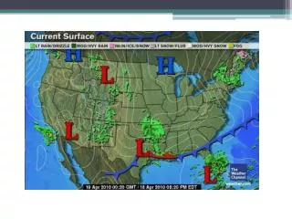
Week at Glance Hazards & Impacts Outlook Tonight Tuesday Wednesday-Thursday Friday-Weekend None MinorSignificant Synopsis A weak upper level system will approach the state on Tuesday and draw some moisture northward from the Gulf of Mexico. Spot showers and thunderstorms will be possible favoring western and southern areas Tuesday afternoon into Tuesday night. The winds will turn stronger Wednesday and Thursday as the jet stream slides southward. A dry pattern is indicated Friday into the weekend.
Weekly SST Departures (oC) for the Last Four Weeks • During the last month, the SST anomalies were increasingly positive in the eastern Pacific and near the International Date Line. • Over the last month, changes in equatorial SST anomalies were mostly positive across the Pacific.
SST Outlook: NCEP Coupled Forecast System (CFS.v2 ) Issued 24 March 2014 The CFS.v2 ensemble mean (black dashed line) predicts ENSO-neutral through the N.H. spring 2014 followed by El Niño starting in May-July (MJJ) 2014
Interesting Trends for AMJ! Forecast Precipitation Rate Anomalies Multi Model Ensemble Mean below above above APR MAY JUN NCEP CFS.v2
As always… Stay up to date… weather.gov/abq Facebook @NWSAlbuquerque & #nmwx NOAA Weather Radio Favorite Media Outlet mobile.weather.gov NMroads.com