Data Integration and Products
280 likes | 435 Views
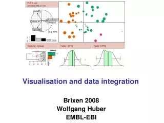
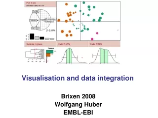
Data Integration and Products. A. Bingham, F. Collard, C. Donlon, J. Johannessen, J.-F. Piollé CWPs Bourassa et al., Cippolini et al., Dohan et al., Donlon et al., Goni et al., Lagerloef et al., Scott et al. Realizing the (full) potential …. timeliness. real-time. delayed mode. Scale.

Data Integration and Products
E N D
Presentation Transcript
Data Integration and Products • A. Bingham, F. Collard, C. Donlon, J. Johannessen, J.-F. Piollé • CWPs Bourassa et al., Cippolini et al., Dohan et al., Donlon et al., Goni et al., Lagerloef et al., Scott et al. • Realizing the (full) potential …
timeliness real-time delayed mode Scale global regional direct observation griddedproducts combined or merged products Product level Level 1 to Level 4 • Start with level 1 and 2 swath data • Sensor physics, retrieval algo, cal/val activities,… • Can serve a wide range of needs but not always convenient (data volume, sensor patterns,…) • Developping synoptic products Level 3 • Gap free, fix grid, small volume, long-time series • Wider range of users, forcing fields • Sensor merging • Improved temporal resolution • New products: fluxes, … • Higher resolution, local sensor calibration • Specific regional products • New derived quantities • New communities : biogeochemical studies • Toward real-time • Serving more specific demands • Model assimilation and forcing products • Monitoring of regional areas • Rapid assessment
L4 SST products (GHRSST-PP project, Medspiration (ESA)) • Objective : high resolutiongap free maps of SST fundation • Optimal interpolation • Merging all sensors available (high resolution IR [AVHRR NOAA&METOP, MSG, AATSR, GOES] and low resolution MW [AMSRE,TMI]) • Intercalibration of all sensors against AATSR • High (10km) to very high resolution (2km): ~90 Gb L2P data received
Opening the Pandora’s box ? • Archiving data leads to very large heterogeneous and multimodal databases Data assimilation is growing in response to the growth of datacollected, but (personal opinion) tremendous amounts of information still remain hidden in data archives. • Knowledge trees and complex algorithms are essential to avoid the Google’s principle, i.e. pertinence = popularity Research efforts to be concerned with the definition of adequate exploratory processes to detect relevant patterns in large, heterogeneous, multidimensional observation data sets with different resolutions to better approach complex spatial and/or temporal dynamics of the ocean system.
Improved Synthesis and Analysis • Forcing fields and fluxes • Global ocean surface circulation estimates combining satellite (altimetry, scatterometer winds) and in situ, e.g. OSCAR, SURCOUF, … • Tools and Applications: Eddy tracking, StormWatch, Stormtracks, …, SSTFronts, Optical-Flow or correlation methods, … Image analysis, … • Dynamical frameworks: • use of Earth Simulator numerical experiments to build transfer functions, e.g. effective Surface Quasi-Geostrophy, • Geometrical-Optics Wave propagation
Waves across the Pacific revisited « A comparison with meteorological events in the Southern Ocean would be far more meaningful if such Observations could be made at a time when a weather satellite is in suitable orbit » (Munk et al. 1963) • SAR is the swell instrument • ERS and ENVISAT wave mode products Data sources: NDBC buoys ENVISAT ASAR Altimeters (+propagation models)
Stormwatch + wavetracker RED : ENVISAT ASAR GREEN : ENVISAT RA2 YELLOW : JASON ALTIMETER
Observed propagation of 13s to 17s swell from July 8 to July 20, 2004 • 6 hour time step • Wavelength from 300 to 450m • Wave period from 13 to 17 seconds
Singularity exponents • AMSR-E SST 3 day mean • March 1, 2008 • More examples inTuriel et al, RSE 2008
Single antenna SAR Doppler anomaly analysis (a poor-man surrogate for interferometry)
High resolution 3D upper ocean dynamics reconstruction from surface data
Hidden information • … most observations are not yet sufficiently explored and used Synergy between Very-high resolution observations to reveal near-surface dynamics, convergence/divergence fronts and roughness contrasts
Cape Agulhas Glitter Glint Glare
SST Laplacian Optical roughness Radar roughness
New Challenges: to estimate Sea Surface Salinity from space SMOS and AQUARIUS coming soon: crucial ancillary information needed First analysis using existing AMSR-E (C and X-band) brightness temperature measurements: sensitivity 10 times lower than L-band dedicated measurements
Monthly AMSR-E climatological SSS products over period 2003-2008
Thoughts … • An ideal instrument … (cloud-free, wide-swath, high-resolution, topography, roughness, Doppler, emissivity, reflectance, …) = the combined use of observations • Improved technologies (instruments, resolution, computer capabilities, storage, dissemination) all contribute to improved combined analysis • Theoretical and dynamical frameworks must be used to assess the quiddity, causes, contexts and essences of the different observations (including sensor physics, observability conditions and instrument capabilities) • Development of future observing systems (including in situ) to capitalize on such a wealth: new analyzing tools and improved dynamical frameworks shall complement the definitions of new sensors.
And more … • Thematically-driven Mining applications shall rapidly emerge to avoid the data deluge, and to emphasize the synergy between observations (in situ and satellite), numerical simulations and theoretical developments • 'collaborative' efforts to promote future developments to avoid (limit) computation burden and/or (redundant) archive volume growth. • Data on an EO-'cloud' and software utilities/applications more efficiently developed to search, process, visualize, analyze the data in a common approach. • Usual discussions – the need for standard data formats, metadata conventions, open access etc.