Download

1 / 23
230 likes | 266 Views
Explore the importance of geography in analyzing U.S. Census data, including population statistics, urbanization trends, geographic classification hierarchies, and core-based statistical areas. Discover how census designations influence data presentation and interpretation.

E N D
Census Bureau Geographic Entities and Concepts
Why is geography important? • U.S. population, Census 2000 • Maryland population, Census 2000 • Prince George’s County, MD population • Washington, DC metro area • Howard County, MD residents who work in Prince George’s County • Young, single, college educated who moved to DC MSA 1995-2000 • Guerra, TX CDP population • U.S. percent urban, Census 2000 • 281,421,906 • 5,296,486 • 729,628 • 4,796,183 • 14,538 • 90,851 • 8 • 79.0
Miami and Vicinity, 1990 and 2000 1990 Census definition West Palm Beach Census 2000 definition Fort Lauderdale Miami-Hialeah Miami Total pop: 3,947,642 Pop: 4,919,036 Miami Pop: 3,952,501 Census 2000 criteria applied to 1990 data
Pink- Block Groups Green – TAZs Potential Disclosure Concerns: Traffic Analysis Zones, downtown San Francisco
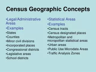
Legal/Administrative Areas Examples: States Counties Minor civil divisions Incorporated places Congressional districts Legislative areas School districts Statistical Areas Examples: Census county divisions Census designated places Census tracts Metropolitan and micropolitan statistical areas Urban areas Public Use Microdata Areas Traffic Analysis Zones Census Geographic Concepts
Places • Incorporated Places • Legally bounded entity • Referred to as cities, boroughs, towns, or villages, depending on the state • Census Designated Places (CDPs) • Statistical entity • Created to present census data for an area with a concentration of population, housing, and commercial structures that is identifiable by name, but not within an incorporated place • Example: Columbia, MD; Paradise, NV
Paradise, NV CDP Las Vegas Paradise CDP CDP capturing an Economic Center
Urban Area Classification: Census 2000 • Urbanized Areas of 50,000 or more people. • Urban Clusters of 2,500 up to 50,000 people. • Both defined based on population density at the census block and block group levels.
Core Based Statistical Area Classification • Core Based Statistical Area (CBSA) – refers to both metropolitan and micropolitan statistical areas; county-based areas, defined based on commuting patterns • Metropolitan Statistical Area - must have at least one UA • Micropolitan Statistical Area -must have at least one UC of at least 10,000 • Metropolitan Division – subdivision of a metropolitan statistical area • Combined Statistical Area – represents a grouping of adjacent CBSAs. • New England City and Town Area – a city- and town-based equivalent to the county-based CBSAs.
Questions? Geographic area concepts, criteria, codes, and attributes: Geographic Standards and Criteria Branch: x3-3056 Geographic products: Geographic Products Management Branch: x3-1128