
Cultural History and Land Use in Upper Klamath Basin
Explore the cultural history and land use in the Upper Klamath Basin, examining the impact of the 2001 drought on Native tribes, settlers, and the fight for water rights.

Cultural History and Land Use in Upper Klamath Basin
E N D
Presentation Transcript
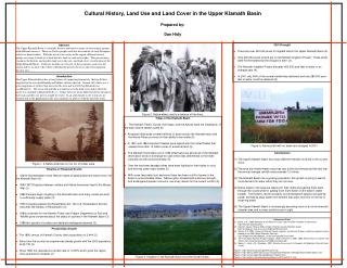
Cultural History, Land Use and Land Cover in the Upper Klamath Basin Prepared by: Dan Hidy Figure 2. Native elders next to a veteran of the Army. Figure 1. A Native American on the rim of Crater Lake. Figure 4. Farmers left with no water are outraged in 2001 Figure 3. Irrigation in the Klamath Basin turns the Desert Green. • 2001 Drought • There are over 400,000 acres of irrigated land in the Upper Klamath Basin (4). • Only 230,000 acres of land are in the Klamath Irrigation Project. These lands were hit the hardest by the drought in 2001 (4). • The Klamath Irrigation Project allocates 450,000 acre-feet of water in an average year (4). • In 2001 only 54% of the normal rainfall was delivered and only 280,000 acre- feet of water could be released (4). Abstract The Upper Klamath Basin is culturally diverse and home to many socioeconomic groups with different interests. There are Native peoples and also descendents of early European settlers or homesteaders. With the recent water crisis in the region, different interest groups are trying to hold on to their historic land use and water rights. This presentation examines the historic and modern land use in the area, and land cover classification of the Upper Klamath Basin. I will also include an overview of the economic census for the region and try to show who will be suffering the greatest losses in this environmental disaster area. Introduction The Upper Klamath Basin has a long history of supporting human life. Before Settlers migrated to the area the Klamath and Modoc cultures thrived. Around 1843 there was a great migration of settlers that moved to the area and in 1863 Fort Klamath was established (1). The town of Linkville was built next to the Link river and in 1893 the name was changed to Klamath Falls (1). Today there are many different interest groups in the basin and they are now in a fight for water. In an arid climate water resources are limited and as the population in the area continues to grow so will the need for water. • Tribes of the Klamath Basin • The Klamath Tribes, Yuroks, the Hupas, and the Karuks were the inhabitants of the basin before settlers came (5) • Ancestral tribal lands covered millions of acres across the Klamath basin and the Native Tribes survived on their ability to be mobile (5). • In 1851 and 1864 important treaties were signed with the United States that ceeded more than 12 million acres of ancestral land (5). • The Klamath Termination act of 1954 effectively took almost all of the Klamath reservation lands in exchange for cash which was detrimental to the tribes culturally as well as economically (5). • Over the last three decades tribes have been fighting for their rights in court and winning some major battles (5). • With some favorable court decisions there has been a shift of power in the basin to accommodate tribes. Native rights, coupled with a serious drought, and endangered species concerns, are a key reason for the current conflict (5). • Conclusions • The Upper Klamath Basin has many different interests involved in the current crisis. • (2) The area has limited water resources due to the arid climate and the fact that the annual average rainfall rarely exceeds 12 inches. • The Klamath Basin has a growing population, this growth is going to lead to more demand for water which they do not have. • Native tribes in the area are rallying for their rights and gaining them back through the courts which is putting even more strain on the basin’s water budget. The Natives, recent droughts, and endangered species are gaining power and taking away water from farmers that were once first on the list of receiving water. • The Upper Klamath Basin is increasingly becoming more of an environmental disaster area and no easy solutions are in sight. • Timeline of Historical Events • 1840’s Homesteaders move West in hopes of gaining land and many move into the Klamath Basin (3). • 1863-1873 Disputes between settlers and Native Americans lead to the Modoc War (3). • 1882 Farmers begin irrigating in the Klamath basin and many canals are built to sufficiently supply water (3). • 1902 Congress passes the Reclamation Act. The U.S. Reclamation Service becomes the Bureau of Reclamation (3). • 1980s scientists for the Klamath Tribes and Oregon Department of Fish and Wildlife grow concerned about the status of suckers in the Klamath Basin (3). • 1988 two species of suckers are declared endangered species (3). • References Cited • Bailey, S.K., 2006, Welcome to the Home of Crater Lake: Klamath Chamber of Commerce, http://klamath.org/relocation/ • (2) Klamath County History, 2006: Oregon Historical County Records Guide, http://arcweb.sos.state.or.us/county/cpklamathhome.html • (3) Markle, D.F., 2002, History of Klamath County irrigation, the Klamath Project, and other important events leading to the 2001 Water Allocation Decision: http://oregonstate.edu/dept/pol_sci/fac/steel/cl/ps507/history.htm • (4) The Truth About Klamath Project Irrigation, Water Deliveries in 2001, 2003: Klamath Basin Coalition Fact • Sheet, http://www.klamathbasin.info/2001waterfacts.pdf • (5) Moore,C., Harty, J.M., Woodrow., 2001: Situation Assessment & Prospects for Mediation, Klamath Basin • Issues • Figure 1: http://www.fluryco.com/galleries/ca12.htm • Figure 2: http://library.weber.edu/asc/ucc/transportation/Railroad%20Images/KlamathFallsIndians.cfm • Figure 3: http://www.oregonwild.org/kbphotos/irrigation.html • Figure 4: http://www.visualsunlimited.com/browse/vu227/vu227471.html • Present Day Growth • The 1890 census of Klamath County cited a population of 2,444 (2). • Since then the county has experienced steady growth with the 2000 population at 63,775 (2). • Since 1990 this represents a growth rate of 10.52% which gives the region more potential for disaster (2).


