Download
1 / 22
220 likes | 324 Views
Explore the spatial distribution of benthos in the Western Arctic Ocean using geostatistics and ordinary kriging. Analysis of benthic biomass data sets from Siberia, Canada, and Alaska to present interpolated surfaces. Discuss results and limitations. Future research on small-scale variability.

E N D
CE 394K.3 GIS in Water Resources Term Project Presentation Determining the Spatial Distribution of Benthos in the Western Arctic Ocean Jon Goodall Environmental and Water Resources Engineering December 6, 2001
Overview • Background • Identify Study Region • Introduce Benthic Biomass Data Sets • Explain Ordinary Kriging • Benthic Biomass in the Western Arctic Ocean • Account for Global Trends • Present Biomass Interpolated Surface • Discuss Results • Conclusions
What is Benthic Biomass? Measurement of amount of living material on the ocean floor (g/m2)
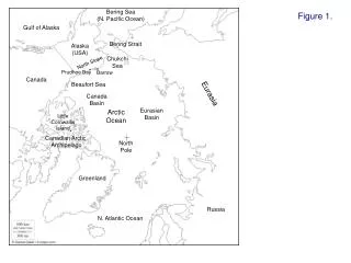
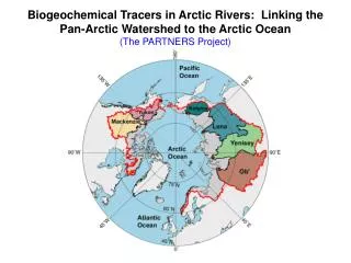
Study Region Western Arctic Ocean Siberia Canada Bering Strait Alaska Pacific Ocean Projection: Lamberts Azimuthal Equal-Area
Stoker (1970 – 1974) Wacasey (1971 –1975) Carey (1971-1976) Broad (1975 – 1981) Feder (1979 – 1986) Grebmier (1984 – 1995) Data Sets Complete Data Set (1970 – 1995) Stoker (1970 – 1974) Wacasey (1971 –1975) Carey (1971-1976) Broad (1975 – 1981) Feder (1979 – 1986) Grebmier (1984 – 1995)
Benthic Biomass at Each Location Siberia Alaska Canada Image created in ArcScene with 3D Analyst
Why Use Geostatistics? “The Geostatistical Analyst uses sample points taken at different locations in a landscape and creates (interpolates) a continuous surface.” -ArcGIS Help Menu Point data Continuous Surface
How Ordinary Kriging Works h = Separation Distance Z(i) = Attribute value at i N = # samples separated by distance h You can find value at any location based on known values at neighboring locations
“One of the main issues concerning Ordinary Kriging is whether the assumption of a constant mean is reasonable.” - ArcGIS Help Menu
Location of Data Split 68.5 º N
Prediction StandardContours Biomass (g/m2) 53 0 – 2.3 71 2.3 – 11.6 11.6 – 49.7 89 49.7 – 204.9 107 204.9 - 838 Benthic Biomass Spatial Distribution(Northern Data Set) Legend
Prediction StandardContours Biomass (g/m2) 432 0 – 37 457 37 – 106 106 – 233 482 233 – 469 507 469 - 3222 Benthic Biomass Spatial Distribution(Southern Data Set) Legend
Semivariograms North South
0 - 105 105- 300 300 - 560 560 - 1000 1000 - 1832 1832 - 3200 Small-Scale Variation a Problem in Southern Data Set Biomass (g/m2) = 1216 = 720 = 405 = 254 Which is it? Biomass (g/m2)
0 - 105 105- 300 300 - 560 560 - 1000 1000 - 1832 1832 - 3200 Small-Scale Variation in Northern Data Set Biomass (g/m2) = 840 = 270 = 269 Biomass (g/m2)
Conclusions • It was possible to interpolate the biomass on a continuous scale with relatively high certainty for the northern region • This method was not capable of accurately predicting biomass in the southern region due to small-scale variability of biomass measurements Future work: Is small-scale variability a result of measuring errors or is it an inherent property of the benthic biomass?
Acknowledgements Dr. Dunton Marine Science Institute UT-Austin Dr. Maidment Center for Research in Water Resources Susan Schonberg Marine Science Institute UT-Austin Jóna Finndís Jonsdottír Previous M.S. Student Center for Research in Water Resources Dr. Barrett Center for Research in Water Resources