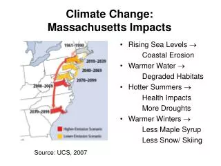
Climate Change Impacts Modeling
240 likes | 422 Views
Climate Change Impacts Modeling. Hideo Harasawa National Institute for Environmental Studies. Objective of AIM/Impact. Projection of potential impacts of climate change on sensitive sectors. Consideration of linkages among affected sectors.

Climate Change Impacts Modeling
E N D
Presentation Transcript
Climate Change Impacts Modeling Hideo Harasawa National Institute for Environmental Studies
Objective of AIM/Impact • Projection of potential impacts of climate change on sensitive sectors. • Consideration of linkages among affected sectors. • Proposition of effective adaptation measures to cope with climate change. • Accounting feedback effects on GHGs concentration and climate system.
Characteristics of AIM/Impact • Area focused: Whole Asia to Global • Spatial analysis (Modules run on GIS) • Consistency between socio-economic scenario and climate change scenario. • Integration of emission (WG3), climate (WG1) and impact and adaptation (WG2) in the institute.
Computation framework GRASS on UNIX Original data Climate data GCM results Soil property Land-use Population etc. GRASS database Variable spatial resolution Meshed raster data Data import interface GRASS commands Climate scenario Output data Output data Input data GIS data Climate scenario creator UNIX shell program GRASS model commands Developed with F77 or C language GRASS Analysis commands Visualization Average, etc. Analysis on PC
Characteristics of AIM/Impact • Area focused: Whole Asia to Global • Spatial analysis (Modules run on GIS) • Consistency between socio-economic scenario and climate change scenario. • Integration of emission (WG3), climate (WG1) and impact and adaptation (WG2) in the institute.
Collaboration with climate model Climate model Atmosphere Emission model Ocean Land Surface Socio-Econ. & Emission Scenario Water Resource Landuse Crop Productivity Socio-Econ. Factors Food Demand And Supply Impact model Adaptation
Crop productivity Soil data Chemical characteristics Slope Texture Climate data Temperature Precipitation Radiation Wind Humidity Human Input Irrigation Machinery Fertilizer Changes in the potential productivity of rice from 1990 to 2050 under the climatic conditions projected using the CCSR/NIES GCM
Agricultural trade Production Crop product- ivity change Tech. Improve Labor Land Demand Population Consumer preference Trade Tariff etc.
River discharge Surface runoff Precipitation Evaporanspiration Temperature Soil characteristics River routing Elevation 2100 1990 Annual river discharge in 1990 and 2100 (UIUC climate model)
Water demand (withdrawal) Driving force Irrigated area Population Water supply coverage GDP or IVA Spatial distribution Population density Cropland distribution
Surface runoff as Water supply Field capacity Vegetation Soil Precipitation Snowfall Evapotranspiration Temperature Wind speed Radiation Humidity Change of surface runoff (2050s – 1980s)
Scarcity index = Withdrawal / Surface runoff Water scarcity
Malaria Reproduction rate of malaria vector Temperature Soil moisture Expansion of the area affected by malaria
IS92c scenario with low climate sensitivity IS92a scenario with medium climate sensitivity IS92e scenario with high climate sensitivity Diminishment of forest Forest vegetation Forest diminishment Temperature Precipitation Evapotranspiration Max. velocity of forest movement
From global scale to national scale • Increasing attention to national-scale impact studies. • AIACC (Assessment of the Impact of and Adaptation to Climate Change Project) • National Communication • Concrete adaptation measures can be evaluated only on an appropriate spatial scale which corresponds the stakeholders.
Development of AIM/Impact [Country] • Package of models, tools and data for scenario analysis of national-scale climate change impact assessment. • Executable on PC-Windows (no need to learn UNIX & GRASS) • Bundled datasets for basic assessment. • Readily achievement of spatial analysis. • Detailed manual documents.
Potential usage of AIM/Impact[Country] • Outside AIM project. • Researchers, governmental officers or others who are interested in assessing future national impact of climate change . • Interactive user interface and ready-made datasets are provided for instant achievement of scenario analysis. • Spatial visualization is achieved with a plain spatial data viewer controlled from AIM/Impact [Country] interface. • Inside AIM project. • Model is improved by replacing the ready-made parameters and data with the specific and detailed ones collected for each country. • Use of IDRISI-GIS is recommended. • Source code and the latest databases are shared among the teams for flexible improvement.
Future Direction of Impacts Study • Global to National, Local Impacts • Vulnerability and Adaptation • Impacts of Extreme Climate Events • Asia Impacts Research Network • Global Warming Research Initiative (Council for Science and Technology Policy, Cabinet Office of Japan) • IPCC 4th Assessment Report & AIACC • Millennium Ecosystem Assessment (MA) • APN Network Activity for Capacity Building