Download

1 / 13
130 likes | 294 Views
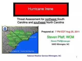
Hurricane Irene Threat Assessment for northeast South Carolina and southeast North Carolina. Prepared at: 7 AM EDT Aug 25, 2011. Reid Hawkins, SOO Donald.Hawkins@noaa.gov NWS Wilmington, NC. National Weather Service Wilmington, NC. New Information.

E N D
Hurricane Irene Threat Assessment for northeast South Carolina and southeast North Carolina Prepared at: 7 AM EDT Aug 25, 2011 Reid Hawkins, SOO Donald.Hawkins@noaa.gov NWS Wilmington, NC National Weather Service Wilmington, NC
New Information As of 5 AM EDT, A Tropical Storm Watch has been issued for the portions of southeast North Carolina and the coastal counties of South Carolina. This includes Bladen, Brunswick, Columbus, New Hanover, and Pender counties in SE NC, and Georgetown and Horry counties in NE SC. A slight westward adjustment of the track and larger forecasted wind field of tropical force winds on the west side of the storm has prompted the issuance of a Tropical Storm Watch. With the storm slightly closer to the coast the rainfall totals for coast southeast North Carolina have increased. This heavier rain could impact the Northeast Cape Fear River. Swells from Irene are now dominating the wave field across the adjacent coastal waters. Residents, especially across southeast NC should prepare for the possibility of moderate flood and wind impacts.
Latest Information Advisory Time:#20 5 AM EDT - August 25, 2011 Position:24.6 North 76.2 West, 80 miles east-southeast of Nassau or approximately 670 miles south-southeast of Wilmington. Intensity:Sustained winds are near 115 mph (Cat. 3). Additional strengthening is possible today and tonight. Movement:Irene is moving to the NW at 12 mph. A turn to the north-northwest today followed by a turn to the north early Friday. Minimum Pressure:950 mb or 28.05 inches. Watches/Warnings: A Tropical Storm Watch is in effect forBladen, Brunswick, Columbus, Georgetown, Horry,New Hanover, and Pender counties and the coastal waters fromSurf City to South Santee River, SC. GOES-Floater IR imagery of Irene 315 AM EDT Next Briefing:The next briefing will be issued around 130 PM EDT Thursday. The next conference call today will be at 0830 AM, followed by another at 3 PM.
Preliminary Threats/Impacts Matrix First Look Hazards specific to southeast NC and northeast SC, and based on current NHC track (note: small change in track can result in significant change to impacts). Moderate Wind and Flooding Impacts primarily for the southeast NC coast, (Low impacts elsewhere) based on the current NHC track. **Refer to Threats/Impacts Summary slides for more detailed information**
Official Track Information High confidence Irene will track toward Outer Banks of NC, likely as a Cat 2 or 3 hurricane Saturday. This is a large hurricane and as a result the wind field was expanded slightly to the west and track was nudged slightly to the west. Given this track Irene will make its closest approach to the Grand Strand and the Cape Fear area Saturday morning. The right front quadrant is not expected to affect southeast NC or northeast SC. Irene NHC Advisory #20 5 AM EDT
Model Information High confidence in the forecast track given the consistency and clustering of models as the storm moves by our coast. Slight adjustments to the track and models appear to have a good handle on the storm. Keep in mind this will be a large storm and impacts will extend well away from the center. Thus do not focus on the center track lines entirely. All interests in the Carolinas should continue to maintain a high level of situational awareness given the forecast intensity and proximity of the storm. 8/25/2011 Ensemble Model Guidance *Note: tropical cyclones can, and do, deviate from the model consensus
Tropical Storm and Hurricane Probabilities The tropical storm force probabilities (left image) remain high across coastal areas, especially southeast NC. The axis of the highest probabilities is very distinct pointing toward the Outer Banks. Low hurricane probabilities also exist primarily along the southeast NC and northeast SC coast. The axis of highest hurricane probabilities extends from far off the SC coast to near the Outer Banks. The probabilities indicate a high chance of experiencing tropical storm force winds for portions of southeast NC, and possibly along the coast of portions of northeast South Carolina. At this time we don’t think hurricane conditions are possible over land this part of the Carolinas unless there is a shift in the track to the west.
Wind Threats/Impacts – Peak Sustained Wind Swath (MPH) **Based on current track/intensity the expected peak sustained wind at the height of the storm** Per the wind swath, the strongest winds will impact the coastal counties, possibly into eastern sections of Bladen and Columbus Counties. Yellow through red represents tropical storm force winds. Winds are in MPH.
Threats/Impacts - Summary Given the current forecast track the thinking is that Irene will have significant maritime impacts across adjacent waters and low to moderate impacts primarily for coastal counties of northeast SC and southeast NC plus Bladen and Columbus County. Wind Impacts – Moderate wind impacts are possible, especially across portions of southeast NC while low impacts are possible along the coast of northeast SC based on the current track. Moderate impacts include: potential damage to roofing, damage to mobile homes especially if unanchored, damage to large signs and shallow rooted trees blown down. Low impacts include minor roof, porch, awning, and carport damage. In addition, large branches may break off trees, and weak/diseased trees may blow down. Could be a few power outages, especially in areas with above ground power lines. Storm Surge – Low impacts are expected at this time since the right front quadrant will pass to the east of the area. Astronomical high tides will be high Friday through the weekend because of the new moon. As a result there could be some minor surge along the vulnerable low spots especially as the storm moves by Friday night through Saturday. Tornadoes – No impact expected since the quadrant of the storm that would favor tornadic development will remain east of the area. Flooding – Moderate impacts primarily for coastal southeast NC (low to no impacts elsewhere). Moderate impacts include: streams, creeks, canals, and ditches overflow. Expanded areas of rapid inundation occur at underpasses, low-lying spots, and poor drainage areas. Some streets and parking lots take on moving water. Storm drains and retention ponds overflow. Flood waters may prompt a few road closures..
Projected Rainfall Amounts HPC depiction of rainfall that includes the 5 PM NHC track. Generally higher amounts across coastal southeast NC with less farther southwest, and especially farther inland.
Threats/Impacts – Summary Cont. River Flood – Some significant river issues are expected if the rainfall forecast over eastern North Carolina comes to fruition. If the forecast rainfall does occur then the Northeast Cape Fear River could experience some flooding. Marine – High impacts are expected, with conditions worsening through Saturday. Seas will be highest (possibly up to 20 ft) over the outer Long Bay and Onslow Bay coastal waters Friday night and Saturday morning before subsiding in the wake of the storm. Seas will likely be much higher over the offshore waters and in particular the Gulf Stream (see next slide). Tropical storm force winds will spread across the coastal waters Friday afternoon and persist through Saturday. The strongest winds will occur farther offshore, closer to the track of Irene. Inlet entrances will be hazardous especially during the falling tide beginning Thursday. Dangerous inlet conditions will peak Friday afternoon through Saturday. Improving from south to north in the wake of the storm. Surf - Breakers will build in the surf today, and dangerous surf is likely Friday and Saturday. Rip Currents – The threat of strong and numerous rip currents will increase today and continue through the weekend. A high risk of rip currents is in effect. Aviation – IFR cigs/vsbys KILM, KCRE, KMYR possible Friday into Saturday. Do not anticipate any significant weather delays at this time given the current track. Do not expect any problems at the main inland hubs across the southeast, could have issues from the mid-Atlantic into the northeast states – continue to monitor the evolution of Irene as it moves up the coast.
Max Wave Height Swath – from NC RENCI and UNC This is just one wave model, but it shows an extreme Significant Wave Height swath generated by a major hurricane, especially for the offshore waters (from Advisory #19). Waves are expected to peak across our adjacent waters Friday night into Saturday morning.