Download
1 / 46
460 likes | 596 Views
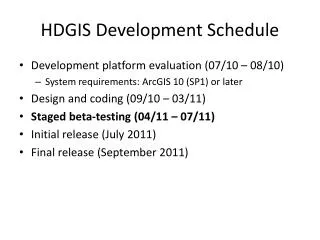
HDGIS Development Schedule. Development platform evaluation (07/10 – 08/10) System requirements: ArcGIS 10 (SP1) or later Design and coding (09/10 – 03/11) Staged beta-testing (04/11 – 07/11) Initial release (July 2011) Final release (September 2011). HDGIS Key Functions. March 28, 2011

E N D
HDGIS Development Schedule • Development platform evaluation (07/10 – 08/10) • System requirements: ArcGIS 10 (SP1) or later • Design and coding (09/10 – 03/11) • Staged beta-testing (04/11 – 07/11) • Initial release (July 2011) • Final release (September 2011)
HDGIS Key Functions March 28, 2011 • HDGIS data management module – 90% done • HDGIS process logging module – 90% done • Define HRUs (HRU Delineation) – 65% done • Refine HRUs (HRU Postprocessing) – 15% done • Enhanced features – TBD during beta-testing
Contributing area rule • Input layers: internal layers only (flow accumulation, flow direction, dem) • Default threshold value = 1 • Default zones = 1
Raster slice rule • Input layers: internal, external, and HRU raster layers • Toggle types: external, terrain, PRISM, HRU, or • 4 separate list boxes (only allow one selection among them) • Default slice method: equal area • Default zone # = 10 • Default base zone value = 1 • Statisics will be displayed when a layer is selected
Raster reclassification rule • Input layers: internal, external, and HRU raster layers • Toggle types: external, terrain, HRU, or • 3 separate list boxes (only allow one selection among them) • Only categorical rasters are available
HRU Zone Post-processing Select AOI HRU001 HRU002 HRU003 View HRU Map View HRU Rules View HRU Info • Output HRU are stored in both • raster and vector format. • The model should allow the use of either metric and English unit. • Generate PRMS radiation plane attributes • Zonal statistics by HRU • Dissolve HRU • Cookie-cut HRU • Conditional clustering/merging of HRU • Size • Number • Variables HRU Info Number: 87 Average Size: Sq Mile 1.8 Max size: Sq Mile 5.45 Output HRU Name: HRU007 Dissolve Query Expression Build Query Dissolve Set Cookie-Cut Template Layer Cookie-Cut HRU Add Delete Run Cluster
Post-processing Cookie Cutter • Input layers: internal, external, and HRU integer raster layers • Default base zone value = 0 • Default mapping table (output value = input value + base) • 0 for disabled zones (i.e., input values that won’t be used) • Layer created by this rule will be used in a con statement, not a combine statement, when generating HRUs.
HDGIS File Structure • Output data path and name: • Internal HRU main folder (AOI_FOLDER/output/zones/) • Internal HRU subfolder (AOI_FOLDER/output/zones/HRUNAME/) • HRU raster name: grid • HRU vector name: grid_v.shp • XML: log.xml • Internal HRU factors (AOI_FOLDER/output/zones/HRUNAME/layers/) • Raster factor name: RXXX_LAYERNAME/grid (XXX: numbers from 001 to 999)
HDGIS File Structure – Output HRUs Zones folder (AOI_FOLDER/output/zones/) Individual HRU subfolder (AOI_FOLDER/output/zones/HRUNAME/) HRU factors (zones/HRUNAME/layers/…) Raster factor name: RXXX_LAYERNAME/grid HRU raster: grid HRU vector: grid_v.shp XML: log.xml
Proposed HRU output structure • Use file-geodatabase raster instead of ArcInfo grid format • Put HRU folder direcely under AOI folder • AOI_FOLDER/output/zones/HRUNAME/ • AOI_FOLDER/HRUNAME/ • Allow Weasel compatible structure when file path doesn’t exceed length limit (112 char)
Meeting minutes on Google site • https://sites.google.com/site/nwccspatialservices/documents/meeting-minutes
HDGIS – HRU Delineation GIS • Main dialog windows • HRU Zone Delineation • HRU Delineation Factors • Pre-processing and templates • HRU Zone Post-processing • Eliminate • Specialized dissolve/clustering • Limited by HRU number • Dissolve based on similarity • Data management • Definition file (AOI HRU management)
HRU Delineation Factors • Topographic • Drainage area defined by • Streamlink contribution area (one, two, three) • Aspect (4, 8, or 16 directions) • Slope grades • PRMS radiation planes (aspect and slope) • Land-cover • Vegetation • Treeline (elevation slice) • Land-cover (bare, grass, shrubs, trees) • Soil (texture) • Geology
Pre-processing Options for Rules • Majority Filter (discrete data) • Low-pass (smooth) filtering (continuous data)
Rule templates • Aspect • Azimuth to directions (4, 8, or 16) • Remove DEM artifacts and speckles • Slope • Low-pass filtering on slope • Slope (degree or %) to slope grades (1: 0 – 5%, 2: > 5%) • Remove DEM artifacts and speckles • Canopy density • Low-pass filtering on % canopy • % canopy to canopy grades (1: 0 – 30%, 2: > 30%) • Remove speckles and small forest patches • Land-use/land-cover • USGS Anderson scheme to hydrological scheme (bare, grass, shrubs, trees) • Remove speckles and small land-cover patches • Soil • Rasterize soil vector data • NRCS soil scheme to hydrological scheme (sand, loam, clay) • Remove speckles and small soil patches
Aspect Template Lookup Table • Continuous (azimuth in degree – 0 to 360, BAGIS)
Slope Template Lookup Table • Continuous (slope in degree – 0 to 90, BAGIS)
Canopy Template Lookup Table • Continuous (% canopy cover 0 to 100, Weasel)
Land-Use Template Lookup Table • Categorical (Anderson classification, Weasel)
Soil Template Lookup Table • Categorical (NRCS)
HDGISFile Structure • Input data path and name: • Internal DEM (AOI_FOLDER/output/surfaces/dem/…) • Internal PRISM (AOI_FOLDER/layers/prism/…) • External layers (AOI_FOLDER/layers/…) • Internal HRU (AOI_FOLDER/output/zones/…) • Output data path and name: • Internal HRU main folder (AOI_FOLDER/output/zones/) • Internal HRU subfolder (AOI_FOLDER/output/zones/HRUNAME/) • HRU raster name: grid • HRU vector name: grid_v.shp • XML: log.xml • Internal HRU factors (AOI_FOLDER/output/zones/HRUNAME/layers/) • Raster factor name: RXXX_LAYERNAME/grid (XXX: numbers from 001 to 999)
HDGIS File Structure - Input Internal PRISM (monthly, quarterly, annual) (AOI_FOLDER/layers/prism/…) User layers (AOI_FOLDER/layers/…) Internal DEM (DEM, Slope, Aspect, etc.) (AOI_FOLDER/output/surfaces/…) Internal HRU (generated by HDGIS) (AOI_FOLDER/output/zones/…)
Input and Output • Raster based process environment • Compatible with vector file through V2R • Input data: • Internal DEM (dem, slope, aspect, flowdir, flowacc) • Internal PRISM (monthly, quarterly, annual, user-defined) • External layers • Internal HRU • Output data: • Internal HRU • Internal factors
HRU Definition File • XML File • Associated with individual HRU generated • Folder structure (weasel compatible, if possible) • Key structure • Lineage blocks (a duplicate copy of the input HRU definition file) • Process blocks
HRU Definition File Components • HEADER: • /comments that will not be interpreted • HRU: • hru_name: String • aoi_name: String • aoi_path: String • hru_zones: Collection • factors: Collection • hru_contiguous: Boolean • hru_number: Short • avg_size: Double • max_size: Double • units: Enumeration • Processes: Collection • date_created: Date • FACTOR • HRU: • hru_name: String • aoi_name: String • aoi_path: String • hru_zones: Collection • factors: Collection • hru_contiguous: Boolean • hru_number: Short • avg_size: Double • max_size: Double • units: Enumeration • Processes: Collection • date_created: Date • FACTOR or POST_PROCESS (but not both)
HRU definition file object model ContribAreaFactor param1: String param2:String param3: Integer AOI IFactor HRU PredefinedZoneFactor hru_name: String hru_path: String parent_name: String parent_path: String hru_zones: Collection factors: Collection hru_contiguous: Boolean number: Short avg_size: Double max_size: Double Processes: Collection date_created: Date layer_name: String layer_path: String defined: Boolean status: Enumeration aoi_name aoi_path comments: String hrus: Collection units: Enumeration param1: String param2:String param3: Integer ReclassifyZoneFactor param1: String param2:String param3: Integer iProcess Each time when the "Generate HRU" or the "Run Cluster" button is clicked, if a parent HRU exists, the model will use the parent's xml as a template, append an HRU object to the xml, and save the xml in the new HRU folder; if there is no parent HRU, then the model will use the HRU object to create an xml in the new HRU folder. Depending on which button is clicked, the IFactor (associated with "Generate HRU") or Iprocess (associated with "Run Cluster" (but not both) will be defined for the HUR object that is appended or added to the xml. SimplifyProcess TemplateProcess DissolveProcess tolerance: Double operator: enumeration min_area: Double layer_name: String layer_path: String dissolve_field: String stat_field: Collection multipart: Boolean Lesley Bross – October s7, 2010
Weasel for Parameterization & PRMS • Geographic feature types that the GIS Weasel is likely to be able to create. These types are used in the parameterization stage. • One: the basin outline • Nhru: hydrologic response units • Nradpl: radiation planes • Nssr: subsurface reservoirs • Ngwres: ground-water reservoirs