Download
1 / 21
210 likes | 344 Views
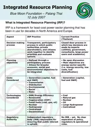
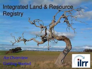
Integrated Land Management Bureau. Integrated Land and Resource Registry. The Integrated Land and Resource Registry is an application that may be used as an initial status tool to determine encumbrances Crown (private) land. I want to build a ski hill, can I do that here?.

E N D
Integrated Land Management Bureau Integrated Land and Resource Registry
The Integrated Land and Resource Registry is an application that may be used as an initial status tool to determine encumbrances Crown (private) land. I want to build a ski hill, can I do that here?
The first step in deciding if a piece of land is available for development is to determine the present encumbrances on that parcel. • Does the parcel have: • An active Crown grant? • Private land? • Other active interests (forestry, mining, etc.)? • First Nation rights? • Protected sites (parks, archaeology sites, etc.)?
Step 1) Use the “Custom Status” tool within the ILRR. Within the “Custom Status” choose the “Location” parameter, this is where you can select your Area of Interest (AOI)
We can determine a location In a number of ways, PID, PIN Title #, grid, legal description, the mapviewer or uploading a “shapefile” to the mapviewer. For our example we will use the Mapviewer.
We’ve selected a certain area… in this instance we’ve “uploaded” a shape file.
We can now select the uploaded shape file and “Accept” the AOI.
We can add a buffer to our AOI, in this example we will go with the default settings.
In our example we have selected one parameter (location), we could narrow the search using the other parameters (such as interest type, including permits, licences and leases) but for this example we will just use the location parameter. When we have selected our parameters – Submit.
For this example we will print to screen, we could also print to “file” (text, spreadsheet, PDF). For larger areas (more than 200 interests) you will be asked to create a “Batch” report. The batch will be emailed to you. Government users can also export as a GML in the Batch report. * I find it handy to add a description when printing to a file.
In our example we have 11 different encumbrances including: 258266 = Mineral Reserve 681775 = Road Permit 394708 = First Nation Statement of Intent Area Looking closer at 258266 we can find more information. (click on hyperlink)
We can see from the detailed report more information about this particular interest, including interest holder and location if available.
We have found the legal encumbrances on the area, now we can look at other resource layers using the “Create Overlay Report”.
The ILRR will return a list of the features that intersect the area of interest.
Users can now save this query. Save the query to other users and create a notification on the query, so you will be notified if the results of the query change. If you are working on a large project or if you are tracking specific interests (competitors), having the most current information is essential.
Save your query with a meaningful name. Describe your query Include other users, government (FCBC or statusers) and industry (BCeID).
The query is saved in your (and other) user profile, under “My Queries and Notifications” You can now create a “Notification”, enabling you to get an email when the results of your query change.
The ILRR provides the initial “status” when looking at encumbrances (interests on crown and private land); it will give information to the USER who must then determine if further research is required. Currently the ILRR provides hyperlinks directly to records in GATOR and the FTA, these applications can be used for further research.
The ILRR, like all other applications, gives the user a certain amount of information. The USER must decide if more information is needed; if more information is needed the ILRR provides access to further research and a certain amount of pertinent information to facilitate research.
Integrated Land Management Bureau Integrated Land and Resource Registry Visit the ILRR www.ilrr.ca Alvin Melton Project Analyst Alvin.melton@gov.bc.ca 250-952-5303