Download
1 / 15
150 likes | 180 Views
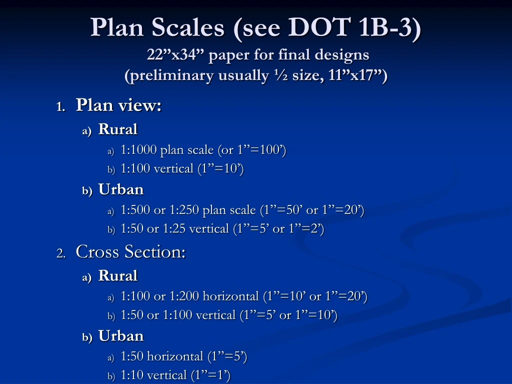
Plan Scales (see DOT 1B-3) 22”x34” paper for final designs (preliminary usually ½ size, 11”x17” ). Plan view: Rural 1:1000 plan scale (or 1”=100’) 1:100 vertical (1”=10’) Urban 1:500 or 1:250 plan scale (1”=50’ or 1”=20’) 1:50 or 1:25 vertical (1”=5’ or 1”=2’) Cross Section: Rural

E N D
Plan Scales (see DOT 1B-3) 22”x34” paper for final designs (preliminary usually ½ size, 11”x17”) • Plan view: • Rural • 1:1000 plan scale (or 1”=100’) • 1:100 vertical (1”=10’) • Urban • 1:500 or 1:250 plan scale (1”=50’ or 1”=20’) • 1:50 or 1:25 vertical (1”=5’ or 1”=2’) • Cross Section: • Rural • 1:100 or 1:200 horizontal (1”=10’ or 1”=20’) • 1:50 or 1:100 vertical (1”=5’ or 1”=10’) • Urban • 1:50 horizontal (1”=5’) • 1:10 vertical (1”=1’)
Plan Elements (review) see ftp://165.206.203.34/design/dmanual/01e-02.pdf (design manual section 1E-2; you have a copy) Title sheet: contract ID, applicable standards/specs, type of work, study area map with project identified, index, design data, mileage, standard plans ref., standards, signature blocks Symbols (legend) Typical cross sections and other features
Plan Elements Estimate of quantities by code #, item, unit, quantity, and supporting notes (if not in spec book) Pollution and traffic control plans Plan/profile sheets Misc. details – joint layout, side road plans, intersection layouts, drainage information, traffic management, soils, earthwork quantities, signs, markings, jointing, structures (often plans on their own)
Plan Pages using Maps: Title sheet • contract ID • standards/specs • type of work • study area map • index • design data • Mileage • standard plans ref. • Standards • signature blocks
14 8a 15 2 5a 6 5b 8b 16 3 1 11 9b 12 4 7 13 17 8c 9a 10 Title Sheet: 1) mileage summary, 2) index of sheets, 3) standard plans, 4) design data, 5) type of work, 6) location, 7) location map/scale, 8) project & ROW number, 9) county, 10) design team, 11) revision block, 12) primary signature block, 13) index of seals, 14) total sheets 15) letting date, 16) references to specifications and value engineering info, 17) sheet number
Plan and Profile Sheets (figure 1, urban intersection reconstruction) Find the North arrow, scale, centerline of construction, stationing, edge of pavement
Find the Township/range, sections, lot, property lines, structures
Woman’s head sculpture, Pond, Retaining wall, Concrete slabs and sidewalks, Utilities (buried pipes • and drainage structures),Detector loops, Centerline striping, Shrubs, Signals, Luminaires