Download
1 / 17
200 likes | 486 Views
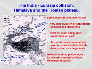
Transboundary Observation Programme on Water and Hazards to the Third Pole Environment Hua Ouyang. Tibetan Plateau as Asian water tower. . Xiangde Xu et al.: World Water Tower, an atmospheric perspective. Geophysical Research Letters ,2008. The ‘Third Pole’. The Big Melt:

E N D
Transboundary Observation Programme on Water and Hazards to the Third Pole EnvironmentHua Ouyang
Tibetan Plateau as Asian water tower .Xiangde Xu et al.: World Water Tower, an atmospheric perspective. Geophysical Research Letters ,2008.
The ‘Third Pole’ The Big Melt: Glaciers in the high heart of Asia feed its greatest rivers, lifelines for two billion people. Now the ice and snow are diminishing. April 2010
Water: a key resource Possibly up to 70% in the dry season
Disasters in South Asia (1975-2005) Source: OFDA/Cred Database
Social-economic stress • Population growth • Food security • Human health
Climate change will depress agricultural yields most in HKH region in 2050 Sources: Müller and others 2009; World Bank 2008c. The figure shows the projected percentage change in yields of 11 major crops (wheat, rice, maize, millet, field pea, sugar beet, sweet potato, soybean, groundnut, sunflower, and rapeseed) from 2046 to 2055, compared with 1996–2005. The yield-change values are the mean of three emission scenarios across five global climate models, assuming no CO2 fertilization (a possible boost to plant growth and water-use efficiency from higher ambient CO2 concentrations). The numbers indicate the share of GDP derived from agriculture in each region. (The share for Sub-Saharan Africa is 23 percent if South Africa is excluded.) Large negative yield impacts are projected in many areas that are highly dependent on agriculture.
Gaps and Challenges • Data availability and data sharing is constrained • Few observation stations in high altitude • Operation and Quality of the existing stations • … …
Reducing scientific uncertainty Himalayas: A blank spot in IPCC AR4 We need to reduce scientific uncertainty!
Under-representation of meteorological stations in the high Himalayas
Priorities: Transboundary Cooperation • River basin approaches (transboundary): • East : Yaluzangbu-Brahmputure • Middle: Koshi river basin--Ganges • West: Indus river basin • Site monitoring and integrated analysis • Existing sites • News sites: high elevation
Wetlands: Upstream-downstream Linkage After Falkenmark, 1999
Relevant Projects • Indus water availability, GTZ, from 2009-2011 • HYCOS, 2010-2012 • SRE-Himala, USAID/NASA, from 2010-2013 • Cryosphere, 2011-2015 • Kosi water resource and poverty reduction, CAS, from 2009-20011, ESPA/DFID
Scientific vision Capacity building for improved monitoring of ice and water resources in the region: • Establish systems for monitoring the status and changes over time of snow, ice and water resources in the region • Build capacity of relevant key institutions on monitoring of snow, ice and water resources using remote sensing and field based techniques • Develop water availability scenarios for river basins • Promote data and information sharing