Download
1 / 26
260 likes | 284 Views
This study evaluates the accuracy of tropical cyclone track forecasts using a combination of the JMA model with ECMWF and JMA initial conditions. Results show that replacing the original initial condition with ECMWF analysis reduces track prediction errors by up to 15% and explains a significant portion of the difference in errors between JMA and ECMWF.

E N D
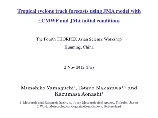
Tropical cyclone track forecasts using JMA model withECMWF and JMA initial conditions The Fourth THORPEX Asian Science Workshop Kunming, China 2 Nov 2012 (Fri) Munehiko Yamaguchi1, Tetsuo Nakazawa1,2 and Kazumasa Aonashi1 1: Meteorological Research Institute, Japan Meteorological Agency, Tsukuba, Japan 2: World Meteorological Organization, Geneva, Switzerland
The position error of 5-day forecasts in 2007 is smaller than that of 3-day forecasts in 1997. Performance of typhoon track predictions by NWP model Time series of 3-yr running mean of position errors by JMA’s Global Spectral Model from 1997 to 2007 (Yamaguchi et al. 2009, MWR) The accuracy of typhoon track predictions has improved steadily over the last few decades
Verification for individual cases Position errors of 3-day predictions by JMA/GSM. Verification period: 3 years from 2008 to 2010. Distance between Beijing and Shanghai Position error (km) Sample Number
Some issues to be addressed • The accuracy of typhoon track forecasts has steadily improved. • Chan (2010, GPTC) Since Chan et al. (2002) paper, research on the physics ofgeneral TC motion has been almost non-existent, which suggests that most scientists are quite content with the current theories of TC motion. Present • In reality, however, significant errors still exist and there are prediction cases where the position error exceeds 1000 km at 3 days. • There are few studies focusing on the cause of prediction errors. (e.g. Carr and Elsberry 2000a, 2000b). Issues Flow of typhoon forecasting Data assimilation NWP Obs. User Forecaster Approach Various sources of prediction errors Any approach to separate them to some extent?
Design of numerical experiments JMA’s global spectral model (JMA/GSM) is run from the ECMWF’s initial conditions, which are available through the YOTC (Year of Tropical Convection) dataset, to distinguish TC track prediction errors attributed to initial conditions from those attributed to the NWP model. Black: Observed track Blue: JMA’s model + JMA’s initial condition Green: ECMWF’s model + ECMWF’s initial condition Red: JMA’s model + ECMWF initial condition
Inter-comparison of typhoon track prediction errors Position errors (km) of 1- to 5-day typhoon track predictions by the unperturbed control member of ensemble prediction system at each NWP center. 58 TCs in the western North Pacific basin from 2008 to 2010 are verified.
Results Experiment period: 2009.07.22 to 2009.11.30 (4 months) Verified TCs: 16 TCs in the west Pac. over the 4 months JM-JI: JMA’s model + JMA’s initial condition EM-EI: EC’s model + EC’s initial condition JM-EI: JMA’s model + EC’s initial condition Position error (km) Number of samples Replacing the original initial condition of JMA/GSM with the ECMWF analysis reduces the TC track prediction errors by 5 %, 11 %, 9 %, 11 % and 15 % at 1 to 5 days, respectively, and explains 20 %, 29 %, 29 %, 38 % and 68 % of the difference in the errors between JMA and ECMWF at 1 to 5 days, respectively. Forecast time (hours)
Individual cases There are prediction cases where the replacement of the initial condition significantly improves the track prediction. Typhoon Dujuan initiated at 12 UTC 5th Sep. 2009 Typhoon Lupit initiated at 12 UTC 21st Oct. 2009 Error reduction at 3 day: 595 km to 122 km Error reduction at 3 day: 720 km to 280 km Black: Observed track Blue: JMA’s model + JMA’s initial condition (JM-JI) Green: ECMWF’s model + ECMWF’s initial condition (EM-EI) Red: JMA’s model + ECMWF initial condition (JM-EI) Orange: JMA’s model + low wavenumber component (≤ T42) of ECMWF initial condition + high wavenumber component (≥ T42) of JMA initial condition (JM-EI2)
Ensemble prediction for those cases Ensemble track prediction by the JMA Typhoon EPS (TEPS) that deals with initial condition uncertainties based on singular vectors. Typhoon Dujuan initiated at 12 UTC 5th Sep. 2009 Typhoon Lupit initiated at 12 UTC 21st Oct. 2009 TEPS captures the scenario of the observed track. It implies that TEPS is successful in expressing the uncertainties of TC track predictions when they are sensitive to initial conditions.
Another individual cases There are prediction cases where the replacement of the initial condition does not help improve the prediction while the ECMWF’s prediction is accurate. Typhoon Morakot initiated at 12 UTC 4th Aug. 2009 Typhoon Parma initiated at 12 UTC 30th Sep. 2009 Black: Observed track Blue: JMA’s model + JMA’s initial condition (JM-JI) Green: ECMWF’s model + ECMWF’s initial condition (EM-EI) Red: JMA’s model + ECMWF initial condition (JM-EI)
Ensemble prediction for those cases Ensemble track prediction by TEPS. All ensemble members show a northward bias and fail to predict the observed landfall. In addition, the ensemble spread is relatively small, which leads the user to mistakenly infer a small prediction error. Typhoon Morakot initiated at 12 UTC 4th Aug. 2009 Typhoon Parma initiated at 12 UTC 30th Sep. 2009 Addressing only the initial condition uncertainties is not sufficient. For better probabilistic predictions, a method for addressing uncertainties associated with the NWP model is needed.
Northward bias –Typhoon Conson (2010) - Northward bias is not a problem only in JMA but also in other major NWP centers. It is noteworthy that such northward bias tends to appear in the east of Philippines. JMA ECMWF CMC UKMO
Northward bias –Typhoon Nanmadol (2011) - It would be of great importance to identify the cause of the bias and modify the NWP systems including EPSs for better deterministic and probabilistic forecasts. JMA ECMWF CMC NCEP
Future study on adaptive observations Typhoon Lupit initiated at 12 UTC 21st Oct. 2009 Black: Observed track Blue: JMA’s model + JMA’s initial condition (JM-JI) Green: ECMWF’s model + ECMWF’s initial condition (EM-EI) Red: JMA’s model + ECMWF initial condition (JM-EI) Orange: JMA’s model + low wavenumber component (≤ T42) of ECMWF initial condition + high wavenumber component (≥ T42) of JMA initial condition (JM-EI2) A research of this kind is important in the western North Pacific basin where the regular aircraft observations are not performed (except for DOTSTAR by Taiwan) Error reduction at 3 day: 720 km to 280 km Focus on prediction cases where the replacement of the initial condition significantly improves the track prediction. Assimilate the ECMWF analysis as bogus observations using the JMA data assimilation system. Investigate the sensitivity area and sensitivity variables (e.g. wind, temperature, water vapor etc.) by changing the locations and variables of the bogus data.
Preliminary results Obs. in the south Obs. In a circle pattern Obs. in the northwest Black dot: Locations of bogus observations Black: Observed track Blue: JMA’s model + JMA’s initial condition (JM-JI) Green: ECMWF’s model + ECMWF’s initial condition (EM-EI) Red: JMA’s model + ECMWF initial condition (JM-EI) Orange: JMA’s model + JMA’s initial condition (JM-JI) with ECMWF analysis data assimilated. The vertical levels of the bogus observations (wind and temperature) are 1000, 850, 700, 500, 300, 200, and100 hPa. Observational errors are the same as those used for conventional rawinsonde observations.
Observations by aircraft in the Atlantic basin • According to Aberson et al. (2006), TC observations by aircraft started in 1943 (observations at the flight level). • Omega dropsonde was first used for the observations in 1982 (Cole et al. 1973) and GPS dropsonde took the place in 1996 (Hock and Franklin 1999). • National Ocean and Atmosphere Administration (NOAA) started the operational synoptic surveillance in 1997 using both G-IV and P-3 aircrafts (Aberson and Franklin 1999). • Aberson (2010) evaluated the impact of the dropsonde observations on the TC track predictions. The average improvement rate is 10 to 15 %. Gulfstream IV-SP (G-IV) NOAA/AOML/HRD website at http://www.aoc.noaa.gov/aircraft_g4.htm
Observations by aircraft in the western Pacific basin • According to Aberson et al. (2006), TC observations by aircraft was conducted in the western Pacific by the US army since early 1950’s . Guard et al. (1992) reported that the observations started in 1945. • However, the operations stopped due to the budget issue in 1987 (Gray et al. 1991, Guard et al. 1992 ) • Dropwindsonde Observations for Typhoon Surveillance near the Taiwan Region (DOTSTAR) has been conducted by the National Taiwan University and the Central Weather Bureau of Taiwan, along with the NOAA since 2003 (Wu et al. 2005). • Wu et al. (2007) evaluated the impact of the dropsonde observations on the TC track predictions. The average improvement rate is 14 % to 19% at 3 day predictions. • THORPEX Pacific Asian Regional Campaign (T-PARC) was conducted in 2008 (Nakazawa 2010). Aircraft "ASTRA“ DOTSTAR website at http://typhoon.as.ntu.edu.tw/DOTSTAR/en/intro/equip.php
“For forecasts of the track of tropical cyclones (TCs), targeted observations have mostly proven to be beneficial statistically.” It is not clear, from both statistical and quantitative perspectives, to what extent observations in sensitivity area improves the TC track predictions with respect to random observations or observations in non-sensitivity area because in the targeted observations, there is no or a few observations in the non-sensitivity area due the limited aircraft resources and limited number of dropsondes. Majumdar, S. J., S. D. Aberson, C. H. Bishop, C. Cardinali, J. Caughey, A. Doerenbecher, P. Gauthier, R. Gelaro, T. M. Hamill, R. H. Langland, A. C. Lorenc, T. Nakazawa, F. Rabier, C. A. Reynolds, R. Saunders, Y. Song, Z. Toth, C. Velden, M. Weissmann and C.-C. Wu, 2011: Targeted Observations for Improving Numerical Weather Prediction: An OverviewWorld Weather Research Programme / THORPEX Publication No. 15, 37 pp.
Summary • JMA/GSM was run from the initial conditions of ECMWF, which are available in the YOTC data set, to distinguish between typhoon track prediction errors attributable to the initial conditions and those attributable to the NWP model. • The average position error was reduced by about 10% by replacing the initial conditions, and in some cases, the predictions were significantly improved. • In these cases, the low wavenumber component of the ECMWF analysis was found to account for most of the improvement. • In addition, the observed tracks were captured by the JMA Typhoon Ensemble Prediction System (TEPS), which deals with initial condition uncertainties. • However, in some case, the replacement of the initial conditions did not improve the prediction even when the ECMWF forecast was accurate. In these cases, TEPS could not capture the observed track either, implying the need for dealing with uncertainties associated with the NWP model.
Summary The representation of the steering flow formed by the synoptic environment around the TCs is important for accurate TC track predictions as demonstrated by various previous studies (e.g. Chan and Gray 1982). Ensemble prediction, which deals with initial condition uncertainties, is successful in expressing the uncertainties of TC track predictions when they are sensitive to initial conditions. There are systematic errors in NWP models. The northward bias that tends to appear to the east of the Philippines would be common systematic errors among many NWP models.
Design of numerical experiments JMA’s global spectral model (JMA/GSM) is run from the ECMWF’s initial conditions, which are available through the YOTC (Year of Tropical Convection) dataset, to distinguish TC track prediction errors attributed to initial conditions from those attributed to the NWP model. • Initial conditions are thought to be essential for accurate predictions in cases where the prediction is significantly improved by replacing the initial condition. • Meanwhile, hints for modifications of the NWP model will be given by cases where the replacement of the initial condition does not help improve the prediction while the prediction by the other NWP system is accurate.
Comparison with verification results over 3 years The difference between JM-JI and EM-EI is similar to that seen in the verification for TCs over 3 years (see figure on the right), that is, EM-EI is better than JM-JI by a lead time of one day.
Results Replacing the original initial condition of JMA/GSM with the ECMWF analysis reduces the TC track prediction errors by 5 %, 11 %, 9 %, 11 % and 15 % at 1 to 5 days, respectively, and explains 20 %, 29 %, 29 %, 38 % and 68 % of the difference in the errors between JMA and ECMWF at 1 to 5 days, respectively. Position error (km) Number of samples Forecast time (hours)
Ensemble prediction for those cases TEPS cannot capture the observed track, either, implying need for modifications of JMA/GSM and/or dealing with model uncertainties in TEPS. Typhoon Morakot initiated at 12 UTC 4th Aug. 2009 Typhoon Parma initiated at 12 UTC 30th Sep. 2009