Download
1 / 25
260 likes | 445 Views
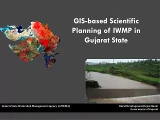
GIS-based Scientific Planning of IWMP in Gujarat State. Gujarat State Watershed Management Agency (GSWMA) Rural Development Department Government of Gujarat. Scheme of the Presentation. GIS Mapping

E N D
GIS-based Scientific Planning of IWMP in Gujarat State Gujarat State Watershed Management Agency (GSWMA) Rural Development Department Government of Gujarat
Scheme of the Presentation • GIS Mapping • Planning for Watershed development • Implementation • Monitoring and Evaluation • Impact Assessment and Feedback
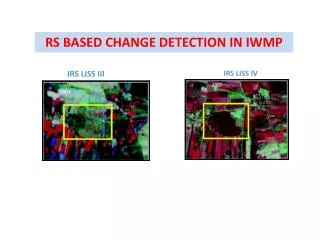
Macro and Micro Level Imagery • Coarser Resolution • Frequent Repetivity Finer Resolution Low Repetivity 3D Availability
The Approach Prioritization of watersheds Developmental Planning Monitoring and Evaluation Incorporating historical development works in Watershed area
Various GIS datasets • Datasets Integrated in GIS • Different Types of Maps can be generated
GIS for Planning From Macro to Micro Selected Taluka Selected District Vadodara District Vadodara Taluka Fajalpur Village, Vadodara Taluka, Vadodara District Selected Village Survey nos. transferred on the plots Plot boundaries on Satellite image
DISTRICT : SABARKANTHA TALUKA : IDAR Mini Watershed : 5F2D4b4 Area : 3590 ha. Planning a Micro Watershed
Land parcels on Satellite Imagery Information at 1:10000
Irrigated areas Unirrigated areas Dhinchaniya Mudeti Dhinchaniya Mudeti Voravav Voravav Information at 1:10000
Forest Wasteland Dhinchaniya Mudeti Mudeti Dhinchaniya Voravav Voravav Information at 1:10000
Geomorphology Contour Maps Contour Levels are relative to the lowest level of the Water shed. Information at 1:10000
Slope Aspect Information at 1:10000
Source : DoLR, GoI Criteria and weightage for prioritization Parameters include components related to Natural Resources and Socio Economic conditions
Source : DoLR, GoI Criteria and weightage for prioritization Parameters include components related to Natural Resources and Socio Economic conditions
Natural Resource Parameters Geomorphology Mini Watersheds Soil Geological structures Drainage Slope
Socio-economic Parameters BPL details Well details SC/ST population
GIS in Implementation • Using GIS Technology, the condition, limitation and potential of the land parcel is derived • Draft Action Plan is prepared on the basis of findings and prescriptions of Agricultural Universities/Research institutes • Draft Action Plan incorporates Ridge to valley approach • Final Action Plan is prepared based on PRA exercises at the village level
Works carried under WDP, ARGW & Irri. Dept. Dugwell Structure Horticulture Plantation Land Improvement Maintenance of Plantation Road Improvement Desilting of Checkdam
Integrated Monitoring & Evaluation System • Monitoring with the help of a web database • Timely updating the database through eGram by Village Watershed Committee • Analysis of the work in progress by PIA (and higher supervisory levels) • Specific and timely corrective measures • Summarised and specialized reports for different hierarchies • Evaluation & Feedback through mobile phone with the help of customized software will be attached to web based GIS
Impact Assessment & Feedback Mechanism • Annual satellite images to assess the impact • Output of the assessment will become input data for the next project. • Effective Planning • Documentation and development of knowledge base • Research Protocol
Conclusion • Holistic approach to Natural Resource Management • The significance of the new approach lies in extending technology to enhance rural livelihoods • Transparency and efficiency • Strengthening coordination among departments • Blending of traditional knowledge and scientific process