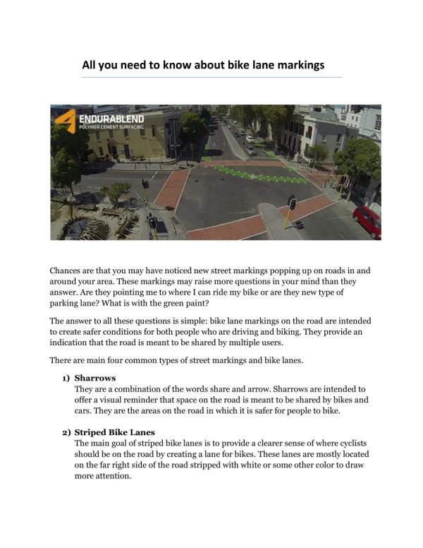
UF BIKE LANE ANALYSIS
200 likes | 391 Views
UF BIKE LANE ANALYSIS. DECEMBER 2, 2013 KELSIE HOECHERL, MARIA MISSENA, & SOPHIA SAPORTAS. IMPROVING BICYCLE TRANSPORTATION ON THE UNIVERSITY OF FLORIDA CAMPUS.

UF BIKE LANE ANALYSIS
E N D
Presentation Transcript
UF BIKE LANE ANALYSIS • DECEMBER 2, 2013 • KELSIE HOECHERL, MARIA MISSENA, & SOPHIA SAPORTAS
IMPROVING BICYCLE TRANSPORTATION ON THE UNIVERSITY OF FLORIDA CAMPUS • Policy 1.1.7: The University shall cooperate and coordinate with the City of Gainesville, Alachua County, FDOT and the MTPO to identify and implement means to improve bicycle facilities within the context area.
Background Information • UF Campus • 2,000-acre campus • 900 buildings • Approximately 5,000 cyclists daily • Research on pedestrian and bicycle behavior indicates: • willing to walk 1,000 to 1,500 feet between destinations (5-10 minutes) • will bicycle up to three miles • Constraints to development • Crashes by mode
Cycling Deterrents • Security during allocated times • Not enough information about regulations while riding a bike • Limited connectivity • Risks of crashing into pedestrians and cars Policy 2.2.11: Corrective measures shall be identified and implemented in areas that experience bicycle and pedestrian conflicts.
Use GIS to analyze the existing bike lanes on the University of Florida’s campus and target the areas where cyclists do not feel comfortable sharing lanes with pedestrians or automobile traffic. GOAL:
SHARING LANES • UF cyclists surveyed said that 250 ft was the maximum distance that they felt comfortable riding next to a vehicle or pedestrian.
Proposal Plan • Target paths that cyclist feel uncomfortable riding along with pedestrians and vehicles • Identify heavy flow areas of cyclist on campus • Analyze intersections of these paths with heavy flow areas as gaps for bike lanes • Target zones that need improvement so that cyclist feel more comfortable; therefore, people get encouraged to ride their bikes to campus more often.
Data Defined • Shared Use Paths: Paths shared between bikes and pedestrians as well as paths shared between bikes and vehicles. • Bike Racks Inventory: Availability of racks on campus. Analyzed by usage • UF Buildings: Buildings will be used as a reference for the areas that need improvement
Methodology Share-Used-Paths greater than 250ft Buffer by 200 ft Select by Attributes (Length) Clip intersection of buffers Select by Attributes Select by Attributes (Description) Heavy Usage Bike Racks Buffer by 150 ft Gaps greater than 250 ft Select by location (intersection of two layers) Highly affected Buildings/Zones UF Buildings layer
SELECTION: SHAREDUSE PATHS LAYER • By attributes, we extracted paths with a length greater than 250ft.
SELECTION: BIKE RACK INVENTORY 2010 • By attributes, we selected hose bike racks that were deemed “heavy usage” from NOTES06
BUFFERING • THE SELECTED “HEAVY USAGE” BIKE RACKS WERE BUFFERED BY 150FT. AS DETERMINED BY RESEARCH ON WALKING DISTANCES.
BUFFERING • SHARED USE PATH SELECTION BY 200 FT.
CLIPPING • CREATED CLIP THAT SHOWS INTERSECTION BETWEEN THE SHARED USE PATH BUFFER AND THE BIKE RACK
SELECTION • SELECTED BY LOCATION THE BUILDINGS THAT INTERCEPT THE CLIP
Conclusion • There is a definite need to develop a safer way for cyclists to navigate around UF’s campus without pedestrian or traffic interference in heavy usage areas targeted: • J. Wayne Reitz Union • Chemical Engineering Building • Chemistry Laboratory • Residence Halls: • Hume Hall • Kenne Flint Hall • Angela Mallory Hall • Mary Reid Hall • Nancy Yulee Hall • Beaty Commons
SOURCES • HTTP://WWW.FACILITIES.UFL.EDU/PLANNING/CMP/MP0515/TRANSPO%20D&A.PDF • HTTP://WWW.FACILITIES.UFL.EDU/PLANNING/CMP/MP0515/TRANSPORTATION%20ELEMENT%202005.PDF • HTTP://WWW.FACILITIES.UFL.EDU/PLANNING/CMP/ • HTTP://WWW.FACILITIES.UFL.EDU/PLANNING/CMP/MP0515/2_URBAN%20DESIGN%20D&A.PDF All screenshots are original work of the authors created through either ArcGIS or GoogleEarth and therefore their property. Only to be used with explicit consent.