Download
1 / 16
160 likes | 175 Views
This project focuses on understanding the formation, intensification, and structure changes of tropical cyclones in the western North Pacific. It incorporates multiple space and time scales and aims to increase the predictability of these cyclones.

E N D
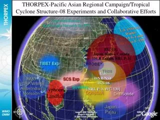
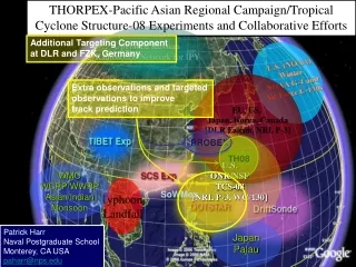
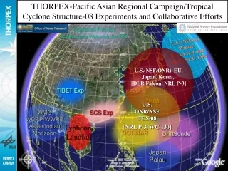
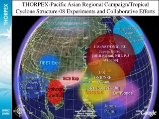
THORPEX-Pacific Asian Regional Campaign/Tropical Cyclone Structure-08 Experiments and Collaborative Efforts Upgraded Russian Radiosonde Network for IPY U.S. (NOAA) Winter NOAA G-4 and Air Force C-130s U.S.(NSF/ONR), EU, Japan, Korea, [DLR Falcon, NRL P-3 WC-130] U.S. ONR/NSF TCS-08 [NRL P-3, WC-130] WMO WCRP/WWRP Asian/Indian Monsoon SoWMEX Typhoon Landfall Japan Palau
Tropical Cyclone Structure - 2008 I: Tropical Cyclone Formation II: Tropical Cyclone Intensification III: Tropical Cyclone Structure Change Acknowledgments: Office of Naval Research, Marine Meteorology National Science Foundation, Large-Scale Dynamics USAF, 13th AF
Key science questions to be addressed in a program aimed at increased understanding and predictability of tropical cyclone characteristics during formation, intensification, and recurvature over the western North Pacific • Highlights • Incorporates multiple space and time scales • Large scale controls • Global and basin-wide spatial scales • Medium-range and synoptic temporal scales • Mesoscale organization pathways • During formation • During intensification • Primary hypotheses with respect to: • Large-scale role in pre-conditioning • Mesoscale organizational pathways leading to construction of a potential vorticity monolith • Role of low-level convergence associated with deep convective cells • Stratiform regions of mesoscale convective systems • Relative roles of environmental and vortex structures in determining the evolution of the outer wind structure • In tandem with the THORPEX Pacific Asian Regional Campaign (T-PARC)
Tropical cyclone formation, structure and structure change:Challenges to Maritime Operations • Variety of conditions from which a tropical cyclone may form over the western North Pacific Pre-TY Tokage monsoon depression TY Tokage 0000 UTC 14 October 2004 Warning graphics from the Joint Typhoon Warning Center for TY Tokage. The shaded region defines the danger area to be avoided. This area is based on the uncertainty associated with track and outer wind structure over the ensuing five days. Note: The danger area nearly covers the entire East China Sea for a period of at least 5 days. The change in track forecast from straight to recurvature, which may be due to the influence of the outer wind structure TY Tokage: 0000 UTC 14 October 2004 TY Tokage: 1200 UTC 15 October 2004
Tropical cyclone formation, structure and structure change:Challenges to Maritime Operations • Midget tropical cyclones often develop in narrow zone along the periphery of a monsoon gyre or in association with an upper-level trough http://www.nrlmry.navy.mil/tc_pages/tc_home.html TS Danas (11W) Danger area graphic 0000 UTC 9 Sep 2007 TS Danas (11W) 1200 UTC 8 Sep 2007 For this small tropical cyclone, the danger area is only 4 deg. in diameter and there is no change in track
How does the large-scale atmosphere and ocean environment control the mesoscale environment prior to tropical cyclone formation? Large-scale modes of variability Objective: medium-range predictability of the tropical large-scale environmental factors that influence tropical cyclone formation
What are the relative roles of the primary mesoscale mechanisms (bottom-up and top-down) in determining the location, timing, and rate of tropical cyclone formation in the monsoon trough environment of the tropical western North Pacific? http://www.nrlmry.navy.mil/sat_products.html http://www.nrlmry.navy.mil/sat_products.html 10o 19o Pre-Fitow (10W 2007) disturbance Pre-Man-Yi (04W 2007) disturbance Objective: Increased predictability associated with the location, timing, and rate of tropical cyclone formation over the western North Pacific
What are the relative roles of environmentally-induced and vortex-generated mechanisms versus cyclogenesis-determined initial conditions in determining the outer wind structural evolution of western North Pacific tropical cyclones? Synoptic Type: Large Tropical Cyclones Combination type Large and Small Tropical Cyclones Synoptic Forcing Mesoscale type: Small Tropical Cyclones Mesoscale Forcing Objective: Increased understanding and predictability of factors that impact the evolution of the outer-wind structure of an intensifying tropical cyclone over the western North Pacific.
What are the key structural aspects of the tropical cyclone and its environment that limit the predictability of recurvature and the start of extratropical transition over the subtropical western North Pacific? Increase in forecast uncertainty over tropical and midlatitude regions often occurs due to tropical cyclones and the movement of tropical cyclones into the midlatitudes TY Tokage, October 2004 Tracks from the JMA ensemble prediction system Tracks supplied by Dr. T. Nakazawa
Ensemble Prediction System from the European Center for Medium Range Weather Forecasts (ECMWF) 5-Day Forecasts associated with the Extratropical Transition of TY Maemi (2003) TY Maemi Large spread among members implies decreased predictability Agreement among members implies high predictability Graphic supplied by Prof. S. Jones and D. Anwender
NW NOAA 43 1430-1520Z 10,000’ North TMI 85H 9-22-05 1443Z Satellite – Aircraft Comparisons Hurricane Rita Graphic supplied by J. Hawkins
Observing Platforms (1 August – 30 September) • NRL P-3/ NCAR ELDORA/ DWL lidar/ GPS Dropwindsondes • 50/50 funding split between NSF and ONR • Operation from Andersen AFB, Guam, Kadena AFB, Okinawa, Atsugi NAF, Japan • Total of 150 research hours • 450 dropwindsondes (30 sondes per mission) • USAF Reserve 53rd Weather Squadron (Hurricane Hunter) WC-130J • Funding from ONR and USAF • Operation from Andersen AFB, Guam, Kadena AFB, Okinawa, Yokota AFB, Japan • Dropwindsondes • Stepped Frequency Microwave Radiometer • AXBTs, Drifting Buoys • Other Components • DOTSTAR • Driftsondes • Launch from Hawaii • 20 balloons with dropwindsonde gondolas • 40 dropwindsondes per gondola • Satellite: MTSAT rapid scan, Polar orbiting platforms
Pre- TY 10W (Fitow) Disturbance Combined missions during tropical cyclone formation Use of Eldora to measure characteristics associated with deep convection Use of WC-130 to measure the environmental characteristics
Midlatitude operating region NRL P-3, FALCON Extratropical Transition (ET – recurvature), Downstream Impacts ET characteristics, forcing of downstream impacts, tropical/midlatitude interactions, extratropical cyclogenesis Subtropical operating region Driftsonde, NRL P-3, DOTSTAR, WC-130 TC Intensification and structure change Recurvature, initiation of ET TC track characteristics, tropical/midlatitude interaction Tropical operating region Driftsonde, NRL P-3, DOTSTAR, WC-130 Tropical Measurements Large-scale circulation, deep convection, monsoon depressions, tropical waves, TC formation T-PARC/TCS-08 Components TY Nabi, 29 Aug – 8 Sep, 2005 Japan, Atsugi, NAF Okinawa, Kadena AFB Guam, Andersen AFB
Driftsonde center, Boulder, CO Okinawa Japan Operations center, Monterey, CA Taiwan Aircraft locations, and aircraft operations centers Driftsonde release, Hawaii Guam T-PARC and TCS-08: GLOBAL OPERATIONS
Summary • Much recent national and international attention on TCs • Four Major Weather Forecast Problems in the Pacific • Lack of understanding of storm scale processes is the biggest knowledge gap (basic research common to all four) • Proposing: • First major WESTPAC field experiment since TCM93 • First detailed observations of TC outer winds, genesis & life-cycle (in situ aircraft, radar, dropsondes, lidar, remote sensing) • First measurements. to validate new and advanced satellite obs. of WP TCs • Utilize the post-CBLAST coupled ocean-wave-atmosphere modeling system as a testbed to gain understanding of the processes as informed and constrained by the field data • Expected accomplishments: • Increase the predictability of the environmental forcing, formation, outer wind structure and intensity of TCs over the western North Pacific • Leverage several international efforts • GOAL: to reduce errors in TC structure and intensity forecasts by 50% within a decade • will also increase warning times and improve ocean and wave forecasts