Download
1 / 13
130 likes | 212 Views
Learn how to engage with local community groups, fire councils, and government cooperators to create fire-safe landscapes. Discover strategies for planning meetings, sharing information, and collaborating with agencies to achieve common goals effectively.

E N D
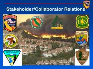
LOCAL COMMUNITY GROUPS • Fire Safe Council’s • Resource Conservation Districts • Fire Wise Communities • Homeowner Groups • Cattleman’s Associations • Farm Bureau • Any other group interested in creating a fire resistant landscape
PLANNING • What are the Units Goals and Objectives • How does each group fit into the big picture • Do your homework on the group that you are meeting with, past issues or successes • Work with people in your organization that have prior knowledge with the group
SET UP A MEETING • Have a plan that is realistic and achievable (gather information) • Maps of the area of mutual interest • Unit plans for projects in the area • Be open to ideas • What do you have to offer? • Be a good listener • Be honest, professional and timely
FOLLOW UP • Share the information with your agency • Complete the tasks that you have taken on in a timely manner • Continue to attend future meetings or have a representative attend • Be aggressive in your cooperation
GOVERNMENT COOPERATORS • Federal & State Land Management Agencies • USFS • BLM • FWS • BIA • State Parks • Local County Departments • Local Fire Departments
INFORMATION SHARING • GIS DATA • Project data • Road layers • Pre Attack Maps • Parcel Information • Endangered Species and Plants • Project planning • Things you haven't even thought of yet
AGENCY COLLABORATON • What is the Fire Plan and how does it affect what they do. • Share new technology with the field • Information not given to the folks on the ground is information wasted. • Need to work with the field BC’s to facilitate and design projects.
WHAT CAN YOU PROVIDE • Pre Incident Support • Pre Attack Maps • Ignition Analysis • Fire History • Incident GIS • Collect GPS data at the incident • Provide the report taker with a map prior to leaving the incident.
Training • Annual GPS refresher, DNR Garmin • Google Earth • Scribble Map • Useful Web Sites • FRAP – maps, priority landscapes, web viewer • GEOMAC – Geospatial multi Agency Coordination • GACC – Northern and Southern • FIREHAWK – Google KMZ