Download
1 / 6
60 likes | 129 Views
This research aims to compare satellite and aerial image data for agricultural mapping, assess crop physiological growth and anomalies, and test mobile computing for crop management. Yearly plans include data collection, PDA/GPS/GIS implementation, and data product development.

E N D
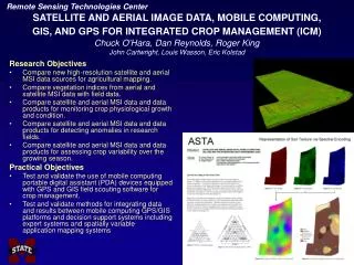
Remote Sensing Technologies Center SATELLITE AND AERIAL IMAGE DATA, MOBILE COMPUTING,GIS, AND GPS FOR INTEGRATED CROP MANAGEMENT (ICM)Chuck O’Hara, Dan Reynolds, Roger KingJohn Cartwright, Louis Wasson, Eric Kolstad Research Objectives • Compare new high-resolution satellite and aerial MSI data sources for agricultural mapping. • Compare vegetation indices from aerial and satellite MSI data with field data. • Compare satellite and aerial MSI data and data products for monitoring crop physiological growth and condition. • Compare satellite and aerial MSI data and data products for detecting anomalies in research fields. • Compare satellite and aerial MSI data and data products for assessing crop variability over the growing season. Practical Objectives • Test and validate the use of mobile computing portable digital assistant (PDA) devices equipped with GPS and GIS field scouting software for crop management. • Test and validate methods for integrating data and results between mobile computing GPS/GIS platforms and decision support systems including expert systems and spatially variable application mapping systems
Remote Sensing Technologies Center SATELLITE AND AERIAL IMAGE DATA, MOBILE COMPUTING,GIS, AND GPS FOR INTEGRATED CROP MANAGEMENT (ICM)Chuck O’Hara, Dan Reynolds, Roger KingJohn Cartwright, Louis Wasson, Eric Kolstad First Year Approach • Base Map Compilation • Accuracy Assessment • Field Data Compilation • Aerial MSI Data Collection • Automation of NDVI Processing • Vegetation Information Product Availability • Standardize Data Products Development • Data Distribution Planning Year Two Plans • Implement PDA/GPS/GIS Technologies • Continue Aerial MSI Collection and First Year Data Collection Components • Satellite MSI Data Collection • Bare Soils Aerial HIS Data Collection • Compile Registration Accuracy Information • Validate Data Products • Improve Data Distribution
Remote Sensing Technologies Center SATELLITE AND AERIAL IMAGE DATA, MOBILE COMPUTING,GIS, AND GPS FOR INTEGRATED CROP MANAGEMENT (ICM)Chuck O’Hara, Dan Reynolds, Roger KingJohn Cartwright, Louis Wasson, Eric Kolstad NDVI Time Series Images First Year Results • Compiled standard methods for generating vegetation indices, change assessment, and automated data product processing; • Developed accuracy assessment methods and horizontal accuracy test range and evaluated aerial MSI data; • Developed standard methods for generating base map data products; • Developed data distribution and management strategy; and • Developed methods for assessing and visualizing general trends in crop growth as well as in-field crop variability. NDVI Change