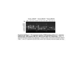
VTEC Primer
170 likes | 423 Views
VTEC Primer. Your Guide to Interpreting VTEC. Outline. Why VTEC? Impact on Operations What Products? The Code Reading VTEC in a product. Why VTEC?. Customers needed an easy-to-decode, uniform way to receive Watch/Warning/Advisory (W/W/A) information

VTEC Primer
E N D
Presentation Transcript
VTEC Primer Your Guide to Interpreting VTEC
Outline • Why VTEC? • Impact on Operations • What Products? • The Code • Reading VTEC in a product
Why VTEC? • Customers needed an easy-to-decode, uniform way to receive Watch/Warning/Advisory (W/W/A) information • Allows start to finish tracking of W/W/As • Allows for quicker dissemination of W/W/A information in conjunction with UGC header • Helps to standardize our products for both internal and external use (webpages, TV crawls)
Impact on Operations • VTEC is generated automatically by NWS software • Mandates use of VTEC-generating software • WarnGen for Feb. 8 products • Necessitates a strict adherence to NWS policy • Mandatory ways to correct inadvertent mistakes • Headline standardization • Especially critical with delay to long-fused products
Initial VTEC Products Initial Implementation on February 8, 2005 • All non-hydrologic convective warnings and follow-up statements • Tornado Warnings (TOR) • Severe Thunderstorm Warnings (SVR) • Special Marine Warnings (SMW) • Severe Weather Statements (SVS) • Marine Weather Statements (MWS) • Only as SMW follow-up • SPC Products • Watch Outline Update (WOU) • Only initial and final issuances
Eventual VTEC Products • Watch County Notification (WCN) • Intermediate Watch Outline Updates (WOU) • All winter weather watches, warnings and advisories (WSW) • All non-precip watches, warnings and advisories (NPW) • Coastal and Lakeshore Flood watches, warnings and statements and High Surf advisories (CFW) • Fire weather watches and Red flag warnings (RFW) • All Hydrologic Products • FFW, FFS, FFA, FLW, FLS • Routine Marine Products (CWF, NSH, GLF, OFF) • NCEP Tropical Hazard Products
Definition of a VTEC Event • An event is a specific combination of phenomenon (e.g., Heavy Snow, Tornado, Wind) and level of significance (e.g., Watch, Warning, or Advisory). • Common examples of events include: Phenomenon Level of Significance Heavy Snow Warning HS W Winter Storm Warning WS W Tornado Watch TO A Wind Advisory WI Y • Each event given an Event Tracking Number (ETN), a four-digit number which stays with the event through its lifetime - from first issuance until upgrade, downgrade, cancellation or expiration.
New Hazard O – Operational VTEC NEW – New hazard (first issuance) KALY – Albany, NY WFO WW – Winter Weather Y – Advisory 0023 – 23rd Winter Weather Advisory issued this year 040519T1600Z – Hazard begins at 16Z on 5/19/04 040520T0300Z – Hazard ends at 03Z on 5/20/04
Continuing Hazard(s) O – Operational VTEC CON – Continued hazard (followup) KALY – Albany, NY WFO ZF – Freezing Fog HW – High Wind Y – Advisory A - Watch 0002 – 2nd Fz. fog adv. 0004 – 4th High wind watch 000000T0000Z – Hazard already in effect 040518T1930Z - Hazard ends at 1930Z on 5/18/04 040519T1600Z – Hazard begins at 16Z on 5/19/04 040520T1000Z – Hazard ends at 10Z on 5/20/04
Cancelled/Cleared Hazard T – Test product CAN – Cancelled hazard KOKX – Upton, NY WFO IS – Ice Storm W – Warning 0005 – 5th Ice Storm Warning issued this year 000000T0000Z – Hazard ongoing 040728T1013Z – Hazard originally ended at 1013Z on 7/28/04
Upgraded Hazard O – Operational VTEC UPG – Upgraded hazard NEW – New Hazard KALY – Albany, NY WFO FW – Fire Weather/Red Flag A – Watch W - Warning 0004 – 4th Fire Wx Watch 0003 – 3rd Red Flag Warning 000000T0000Z – Hazard already in effect 040404T0500Z – Hazard would have ended at 05Z on 4/4/04 040403T1700Z – Hazard begins at 17Z on 4/3/04 040404T0500Z – Hazard ends at 05Z on 4/4/04
Downgraded/Replaced Hazard O – Operational VTEC CAN – Cancelled NEW – New hazard (1st issuance) KALY – Albany, NY WFO SN – Snow WW – Winter weather Y – Advisory 0011 – 11th Snow Adv. 0023 – 23rd Winter Wx Adv. 040519T1600Z – Hazard begins at 16Z on 5/19/04 040520T0300Z – Hazard ends at 03Z on 5/20/04
Expiring Hazard X – Experimental VTEC in an Operational product EXP – Expiring hazard (last issuance of this hazard) KLWX – Sterling, VA WFO SV – Severe Thunderstorm W – Warning 0056 – 56th Severe thunderstorm warning this year 000000T0000Z – Hazard ongoing 040727T1615Z – Hazard ends at 1615Z on 7/27/04
Corrected Hazard O – Operational VTEC COR – Corrected hazard KOKX – Upton, NY WFO BZ – Blizzard A – Watch 0010 – 10th Blizzard Watch issued this year 040713T2232Z – Hazard begins at 2232Z on 7/13/04 040714T2232Z – Hazard ends at 2232Z on 7/14/04
Questions/Comments Contact: Art Kraus arthur.kraus@noaa.gov or Shannon Whiteshannon.white@noaa.gov