LB01, Lamon bay
LB01, Lamon bay. LB01, Bifurcation track. vertical black bar: core X: XBT V: vertical net tows O: oblique net tows Red triangle: TRBM Vertical red bar: line moorings. S-max NPsubtropical. “Port Irene bay”. thermocline. “Port Irene bay”. S-min NPIW. Pressure db [meters].
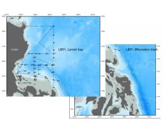

LB01, Lamon bay
E N D
Presentation Transcript
LB01, Lamon bay LB01, Bifurcation track
vertical black bar: core X: XBT V: vertical net tows O: oblique net tows Red triangle: TRBM Vertical red bar: line moorings
S-max NPsubtropical “Port Irene bay” thermocline “Port Irene bay” S-min NPIW Pressure db [meters] Polillo depression Polillo depression Polillo depression O2-min 100-200 m frequent O2-min “Port Irene bay” Lower thermocline O2-min All CTD Stratification: LB01, LB02, LB02 (NE)
NEC S-max Kuroshio S-max LB1 LB02 thermohaline pattern (red and cyan) in Lamon Bay reflects dominance of North Equatorial Current (NEC) water; whereas LB01 (black) reflects Kuroshio recirculation gyre regime. The cyan LB02 stations, with Kuroshio T/S, are in the northeastern part of the station array. The LB02 green stations are within the embayment of Port Irene. The LB02 nascent Kuroshio is composed of NEC T/S LB2 Polillo channel All CTD stations: 1-78 LB1 NEC S-min NPIW Kuroshio S-min LB2
CTD 1-78 NEC, S-max Polillo channel Kuroshio Black: LB0-1 Red: LB02 Cyan: LB02 Green: LB02 LB2 LB1 NPIW Kuroshio
NEC Kuroshio Polillo and ‘Port Irene Bay’ All CTD stations: 1-78 NEC Kuroshio LB02: dominate NEC signature, except in NE part of stations array
LB01 LB02 Focus on Lamon Bay south of 17.5°N: LB01 Black LB02 Red LB01 LB02 Message: the time period (april/may 2012) of LB02 displays greater presence tropical North Equatorial Current water than the LB01 period (May/June, 2011), why?
18.35°N western boundary NEC S-max western boundary North Pacific S-min Kuroshio looking north looking south 17.12°N NEC S-max western boundary western boundary looking north looking north
16.50°N western boundary NEC S-max western boundary North Pacific S-min Kuroshio looking north looking south 124.25°E NEC S-max North Pacific S-max & S-min Kuroshio Southern boundary Southern boundary looking west looking west
Lamon Bay cruise 1, 23-55 m current vectors, Lamon Bay cruise 2, 23-55 m current vectors, as of 8 May 2012 Kuroshio recirculation gyre Nascent Kuroshio Nascent Kuroshio SSS color coded Kuroshio recirculation gyre anticyclone dipole anticyclonic dipole Lamon bifurcation Lamon bifurcation cyclonic dipole cyclonic dipole Weak NEC signal Kuroshio feeder current Polillo current Strong NEC source Polillo current SSS color coded Solid arrows denote stronger flow, with clear T/S source water signal. LB02 Kuroshio recirculation gyre retreats northward to be replaced by NEC waters; LB01 shows southward penetration of the Kuroshio recirculation gyre, with reduced NEC water [vectors not to same scale]
+15.3 Sv +10 Sv, LB01 -5.5 Sv D+2.6 Sv +12.4 Sv +11 Sv, LB01 D-2.2 Sv -10.2 Sv LB02 Transports [~±15%?], upper 300 m
Bifurcation ~13° - 14° N North Equatorial Current Bifurcation 10° - 11° N North Equatorial Current [stronger] Mindanao Current [weaker] Mindanao Current NEC bifurcation, late May 2011, during R/V Revelle transit to south to avoid tyhpoon Songda NEC bifurcation, April 2012, During R/V Revelle transit, Freemantle to Legaspi.
Weaker Kuroshio April 2012 La Niña May 2011 Neutral Stronger Kuroshio, enriched in Equatorial water Kuroshio Kuroshio Luzon Strait throughflow Weak or ~0 Luzon Strait throughflow Weak South China Sea throughflow South China Sea throughflow bifurcation North Equatorial Current North Equatorial Current bifurcation Mindanao Mindanao Stronger Makassar ITF Weaker Makassar ITF For supporting information see ppt slide ‘Notes page’; see next slide for relation to Aviso
Possible Implications of an ENSO [bifurcation] dependent Kuroshio source: § During La Niña there is increased injection of NEC tropical Pacific water into the subtropical North Pacific; during El Niño the subtropical North Pacific is more 'isolated' from the NEC. § The NEC enhanced Kuroshio transport during La Niña, leads to greater northward heat flux into the North Pacific; reduces western pacific warm pool volume. § The NEC injection into the subtropical regime, on climatic average (the integrated La Niña/El Niño phases), balances the loss of North Pacific water through the Bering Straits (~1 Sv) and through Luzon Strait (~3 Sv) into the South China Sea (that most likely advects into the Indian Ocean as part of the Indonesia Throughflow). During El Niño the Kuroshio recirculation gyre reaches into Lamon Bay, to can feed the westward ‘leakage’ into the South China Sea, (Luzon Strait westward transport is increased during El Niño, HYCOM, Hurbert et al 2011). In this way the Kuroshio recirculation gyre exports the accumulated NEC injected during the previous La Niña phases. § More... effect on ecosystems, linkage with PDO, impact on ITF, WPWP ... ITF comment: During El Niño the SCS throughflow via Sibutu Passage blocks Mindanao surface layer leakage to Makassar Strait, which lowers the Makassar net transport, counteracting thegreater Mindanao transport associated with the northern bifurcation position.
Dt = 4°C @ 200 m; 18°C isotherm Dz = @ 70 m Deeper isotherms Kuroshio Shallower isotherms