Download
1 / 30
300 likes | 492 Views
U.S. Census Bureau Data Availability for Geographic Areas. March 25, 2008. Hierarchy. U.S. Regions and Divisions State County County Subdivision Place (or place part) Census tract Block group Block. Census Regions and Divisions.

E N D
U.S. Census Bureau Data Availability for Geographic Areas March 25, 2008
Hierarchy • U.S. • Regions and Divisions • State • County • County Subdivision • Place (or place part) • Census tract • Block group • Block
Search for Data Three factors usually affect the search for data from the Census Bureau: 1. topic (e.g., population) 2. geography (e.g., my state) 3. time period (e.g., most recent year). .
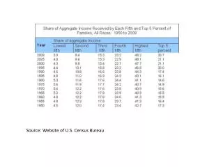
Data Availability Generally the larger the geographic area, the more topics and time periods you can find. U.S. level – Extensive data States and Counties - Substantial data Cities (i.e., incorporated places) – Somewhat less data Small areas (census tracts, block groups, and blocks) - once a decade after the Census Bureau tabulates the results of the Population and Housing Census. In 2010 - the American Community Survey will allow the Census Bureau to release data more frequently for areas as small as census tracts.
Examples of Data by Small Geography • Census 2000 • Summary File 1 (100%) • Census Tract • Blocks - most tabulations • Summary File 2 (100%) • Census Tract • Summary File 3 (Sample) • Census Tract • Block Group - most tabulations • Summary File 4 (Sample) • Census Tract
Examples of Data by Small Geography • Economic Census - 2002 • Zipcode level • American Community Survey – 2006 • • Areas of 65,000+ population
PUMS and PUMAs
Public Use Microdata Sample Microdata allow users to prepare their own customized tabulations of most population and housing subjects using specially prepared microdata files. These files are the actual responses to census questionnaires, but with names or addresses removed and the geography sufficiently broad to protect confidentiality.
What is a PUMA ?Public Use Microdata Area • PUMA is a geographic entity for which extracts of the full range of population and housing data collected from a small sample of confidentiality-screened census records are provided. • PUMAs are sub-state areas that can be composed of: • A large single county or groups of counties • Large places • Groups of census tracts • Combination of tract and county • and • Other variations
PUMA Delineation The Census Bureau offered State Data Centers (SDCs) the opportunity to delineate, or coordinate the delineation of, the super-PUMAs and the PUMAs. The SDCs (or their equivalents) in 48 states, the District of Columbia, and Puerto Rico participated in the delineation program. PUMA codes must be used in conjunction with the 2-digit FIPS state codes. PUMAs: Minimum population of 100,000 - cannot cross a state line. (5% long-form records sample) Super PUMAs: Aggregated PUMAs withaminimum population of 400,000 - cannot cross state lines. (1% long-form records sample)
Large Single County - PUMA 00100 Multiple Counties PUMAs 00500 00200
Large City PUMA 00700 Census Tract Groups PUMAs 00802 00803
Putnam County + One census tract in Westchester County
Data by PUMAs Available Decennial Census American Community Survey
Mapping Online Maps available onwww.census.gov Static Interactive Thematic Reference
Census 2000 Census Tract Map Zoom Pan Select Search
Static Map Reference Map Theme Map
Theme Map County Business Patterns
Interactive Census Tract Reference Map Change Boundaries Pan Zoom in Zoom out Print Download
Static Reference Map Print Download
Reference Map Use Map to Select a Neighborhood Data table is selected Show Result
New York Regional Census Center 330 W. 34th Street – 13th floor NY, NY 10001 646-233-2404