Download
1 / 30
300 likes | 330 Views
Delve into the vast landforms and abundant resources of Russia, from the Northern European Plain to the Caucasus Mountains. Learn about the mighty Volga River, giant lakes, and rich mineral deposits. Discover the impact of continental climate on vegetation, human-environment interactions, and historical events like Napoleon's failed invasion. Engage with fascinating facts and insights about Russia's unique geography.

E N D
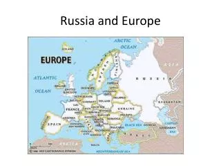
NORTHERN LANDFORMS • Northern European Plain • Chernozem: black earth; some of the world’s richest soils • Large cities: Moscow, St. Petersburg
NORTHERN LANDFORMS CONTINUED • West Siberian Plain • Begins at Ural Mountains and stretches to the Yenisey River • Rivers here flow to the Arctic Ocean
SOUTHERN LANDFORMS • The Caucasus Mountains: between Black and Caspian Seas • Form border between Russia and Transcaucasia: region consisting of republics of Armenia, Azerbaijan, and Georgia
DRAINAGE BASINS AND RIVERS • Main Russian drainage basins: Arctic Ocean, Caspian Sea, Pacific Ocean, Baltic Sea, Black Sea, and Aral Sea • Arctic basin is the largest (Ob, Yenisey, and Lena Rivers)—drains 3 million sq. miles
VOLGA RIVER • Longest river on the European continent • Begins near Moscow and flows south • 2300 miles long • Ends at Caspian Sea • Carries 60% of Russia’s river traffic
LAKES • Area contains the world’s largest lakes • Caspian Sea: saltwater lake • 750 miles wide (largest inland sea) • Aral Sea: saltwater lake • Could vanish within 30 years
LAKE BAIKAL • Deepest lake in the world (more than 1 mile) • Nearly 400 miles wide • Holds 20% of world’s fresh water • 1200 unique species of plants and animals
ABUNDANT RESOURCES • Huge coal reserves, deposits of iron ore • The region is a leader in oil production and natural gas • Russia’s forests hold 1/5 (20%) of the world’s timber resources • One of world’s largest producers of hydroelectric power
RESOURCE MANAGEMENT • Harsh climates and rugged terrain make movement of resources difficult • Many resources are in Siberia: part of Russia that lies on the Asian continent
CONTINENTALITY • Def: the effect of distance on climate • Most of Russia is hundreds of miles away from the sea • This effects precipitation and temperature
TUNDRA • Most northern section of Russia • Mosses, lichens, small herbs, and low shrubs
FOREST • Taiga: south of Russian tundra; largest forest in the world • Mostly coniferous trees • Deciduous trees become more prominent in the lower latitudes
STEPPE • Temperate grassland • Extends from southern Ukraine through northern Kazakhstan • Chernozem
DESERT • The 2 major deserts in Central Asia cover an area of c. 230,000 sq. miles
THE SHRINKING ARAL SEA • Water for Aral Sea comes mostly from the Syr Darya and Amu Darya Rivers • 1950s: governments diverted water for irrigation
EFFECTS OF AGRICULTURE • Pesticides and fertilizers were entering the Aral Sea through Runoff: rainfall not absorbed by the ground that runs into streams and rivers • Killed all species of fish • Disease spread as sediment exposed from the drying of the Sea was carried by wind over population areas
COPING IN SIBERIA • C. 32 million people live in Siberia • Temps can reach -90°F in winter and 94°F in summer • Warmer temps melt ice and snow and leave pools of water for mosquitoes and black flies • Hard to build on permafrost ground
WAR AND “GENERAL WINTER” • The cold climate sometimes helps Russia • Napoleon was turned back in the early 1800s • Began retreat with 100,000 men • Returned with fewer than 10,000 • The winter saved Russia from French occupation
TRANS-SIBERIAN RAILROAD • Links Moscow to Vladivostok • More than 5,700 miles, crossing 7 time zones • Construction lasted from 1891-1903 • Built mainly to speed up travel time of resources
TIME ZONES • Created in 1884 • World divided into 24 time zones • Each time zone represents 15° longitude (360°⁄24 hours=15°) • Prime Meridian is starting point (0°) • Base time is called Greenwich Mean Time (GMT) • International Date Line set at 180°