Enhancing Air Quality Management through Integrated Data Systems
150 likes | 258 Views
This document outlines the current air quality information ecosystem, highlighting the challenges of disparate data sources and the need for improved interoperability. It presents the concept of a Future Integrated Air Quality Information System, advocating for data federation, processing, and user-driven application development. The framework aims to facilitate seamless access to atmospheric data from various providers, enable efficient data mediation, and foster real-time integration and analysis. By utilizing modern web services, the system aspires to enhance air quality forecasting and compliance efforts.

Enhancing Air Quality Management through Integrated Data Systems
E N D
Presentation Transcript
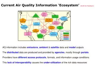
Current Air Quality Information ‘Ecosystem’ (Draft for Feedback) AQ information includes emissions, ambient & satellite data and model outputs The distributed data are produced and provided by agencies, mostly through portals Providers have different access protocols, formats, and information usage conditions This lack of interoperability causes the under-utilization of the rich data resources
Future Integrated AQ information System (Draft for Feedback) Data Federation Distributed, Virtual, Uniform Data Processing Filtering, Aggregation, Fusion Info ProductsReports, Websites NEI DAACs Data are maintained by custodians and exposed through ‘portals’ Mediators uniformly ‘wrap’ data and provide processing services Analysts program the services to create application-specific products Responsibility is shared among data providers and mediator/ integrators ESIPFed can provide the infrastructure and tools for the AQ info system AQ Forecasting NEISGEI IDEA Emission Missions AQ Compliance FireInv GASP DataMart AQMod Network Assess. AIRNow Forecast Status and Trends VIEWS WeaMod Mediators ASOS GloMod
Explore Data Federate Data Understand Info Needs Providers Viewers Emission Surface Satellite Model Single Datasets Slice & Dice Programs Reports Wrappers Structuring Integrate Inform Public AQ Compliance Forecast AQ Status & Trends Satellite Devel. Network Asses. Manage Hazards ……… What? Networking Reuse When? Where? Data Providers Data Users Non-intrusive Linking & Mediation Federated Air Quality Data System -Draft Text 1 Text 2 Run and click PPT Slideshow to see chart animations ESIP AQ Cluster 050510 Draft rhusar@me.wustl.edu
DataFed Description DataFed Vision Better air quality management and science through by effective use of relevant data DataFed Goals Facilitate the access and flow of atmospheric data from provider to users Support the development of user-driven data processing value chains Participate in specific application projects Approach: Mediation Between Users and Data Providers DataFed assumes spontaneous, autonomous emergence of AQ data (a la Internet) Non-intrusively wraps datasets for access by web services WS-based mediators provide homogeneous data views e.g. geo-spatial, time... End-user programming of data access and processing through WS composition (limited) Applications Building browsers and analysis tools for distributed monitoring data Serve as data gateway for user programs; web pages, GIS, science tools DataFed is currently focused on the mediation of air quality data
Anatomy of a Wrapper Service: TOMS Satellite Image Data The daily TOMS images reside on the FTP archive, e.g. ftp://toms.gsfc.nasa.gov/pub/eptoms/images/aerosol/y2000/ea000820.gif URL template: ftp://toms.gsfc.nasa.gov/pub/eptoms/images/aerosol/y[yyyy]/ea[yy][mm][dd].gif src_lon_min src_lat_max Image Description for Data Access: src_image_width=502 src_image_height=329 src_margin_bottom=105 src_margin_left=69 src_margin_right=69 src_margin_top=46 src_lat_min=-70 src_lat_max=70 src_lon_min=-180 src_lon_max=180 • Given the URL template and the image description, the wrapper service can access the image for any day, any spatial subset using a HTTP URL or SOAP protocol: • Wrapper classes are available for geo-spatial (incl. satellite) images, SQL servers, text files,etc. The mediator classes are implemented as web services for uniform data access, transformation and portrayal. src_margin_top src_margin_left src_margin_right src_img_height Transparent colors for overlays RGB(89,140,255) RGB(41,117,41) RGB(23,23,23) RGB(0,0,0) src_img_width src_lat_min src_lon_max src_margin_bottom
SeaWiFS Satellite VIEW by Web Service Composition SeaWiFS Satellite Aerosol Chemical Air Trajectory Map Boarder
Datasets Used in FASTNET Near Real Time Data Integration Delayed Data Integration Surface Air Quality AIRNOW O3, PM25 ASOS_STI Visibility, 300 sites METAR Visibility, 1200 sites VIEWS_OL 40+ Aerosol Parameters Satellite MODIS_AOT AOT, Idea Project GASP Reflectance, AOT TOMS Absorption Indx, Refl. SEAW_US Reflectance, AOT Model Output NAAPS Dust, Smoke, Sulfate, AOT WRF Sulfate Fire Data HMS_Fire Fire Pixels MODIS_Fire Fire Pixels Surface Meteorology RADAR NEXTRAD SURF_MET Temp, Dewp, Humidity… SURF_WIND Wind vectors ATAD Trajectory, VIEWS locs. • Data are accessed from autonomous, distributed providers • DataFed ‘wrappers’ provide uniform geo-time referencing • Tools allow space/time overlay, comparisons and fusion
A Sample of Datasets Accessible through ESIP MediationNear Real Time (~ day) It has been demonstrated (project FASTNET) that these and other datasets can be accessed, repackaged and delivered by AIRNow through ‘Consoles’ MODIS Reflectance MODIS AOT TOMS Index MODIS Fire Pix GOES AOT GOES 1km Reflec NEXTRAD Radar NWS Surf Wind, Bext NRL MODEL
FASTNET:Inter-RPO pilot project, through NESCAUM, 2004Web-based data, tools for community useBuilt on DataFed infra-structure, NSF, NASAProject fate depends on sponsor, user evaluation
Some of the Tools Used in FASTNET • Data Catalog • Data Browser • PlumeSim, Animator • Combined Aerosol Trajectory Tool (CATT) Consoles: Data from diverse sources are displayed to create a rich context for exploration and analysis Viewer: General purpose spatio-temporal data browser and view editor applicable for all DataFed datasets CATT: Combined Aerosol Trajectory Tool for the browsing backtrajectories for specified chemical conditions
Midwest HazeCam Image ConsoleImage Archive and Browser Other FASTNET Consoles Select date and time Set image size and time MW HazeCam Console • Hourly Midwest HazeCam Images are archived by DataFed data access system • Archived images for all cameras can be browsed through this console • HazeCam URL for a day: http://www.datafed.net/consoles/MWH_WebCams.asp?image_width=400&image_height=300&datetime=2005-01-31T13:00:00 • URL for a site and day: http://webapps.datafed.net/datasets/webcam/cincinnati/20050131-13mwhcincinnati.jpg • URLs can be embedded as links into emails, bookmarks, web pages, PPT and PDF files. Midwest HazeCam Image Browser
Aerosol Event Catalog: Web pages • Catalog of generic ‘web objects’ – pages, images, animations that relate to aerosol events • Each ‘web object’ is cataloged by location, time and aerosol type.
Distribution of Responsibility Distributed Responsibility in OpenDAP The data lies with the data providers The data access protocol lies with OPeNDAP Application programs with the developers (Matlab, .. Excel…) Data discovery with the GCMD and NVODS Distributed Responsibility DataFed(??) The data lies with the data providers The wrappers and mediators with DataFed community Application programs with end user Data discovery with data & service registries