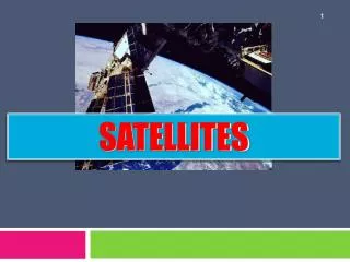

Coordination Group for Meteorological Satellites - CGMS
E N D
Presentation Transcript
A Report on NASA Activities That Strengthen Capacity to Use and Apply Earth Science Data and ProductsPresented to CGMS-41 Working Group II, WGII/10Christine M. Lee1, Ming-Ying Wei1, TsengdarLee1, Daniel Irwin3, C. Duane Armstrong4, Kenton Ross2, Ana Prados4, Karen Moe4, Michael Seablom4, Richard Eckman2, and Nancy D. Searby11NASA Headquarters2NASA Langley Research Center3NASA Marshall Space Flight Center4NASA Goddard Space Flight Center
Coordination Group for Meteorological Satellites - CGMS • Intended to stimulate discussion of potential synergistic efforts between CGMS Virtual Labs and NASA ESD capacity strengthening activities • Provides overview of capacity strengthening activities across ESD, with summaries of projects from ESTO, R&A, and Applied Sciences • Capacity activities discussed: • Access to NASA satellite data (LANCE, IMAPP) • Transition research to operations (JCSDA, SPoRT) • Students to utilize Earth science data (GLOBE, NESSF, SARP) • Technology development projects (Next Gen RT Geodetic Sensor, Disasters/Risk Mgmt) • ASP’s Capacity Building Program, comprised of four Center-led efforts (ARSET, DEVELOP, GOMI, SERVIR) and HQ-level activities (CEOS WGCapD, USWP, GEOSS in the Americas) Overview
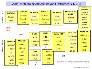
Coordination Group for Meteorological Satellites - CGMS • Land Atmosphere Near real time Capability for EOS (LANCE, co-located with NASA EOSDIS) processes data quickly to serve application users, operational agencies, and researchers who need EOS products with faster turnaround • International MODIS/AIRS Processing Package (IMAPP) allows ground stations to create a suite of MODIS, AIRS, AMSU, AMSR-E products from Terra and Aqua and is freely available Strengthening the capacity to access NASA satellite data
Coordination Group for Meteorological Satellites - CGMS • Joint Center for Satellite Data Assimilation (JCSDA) is a collaborative effort between NOAA, NASA, US Navy, and US Air Force that enables assimilation of satellite observations daily and facilitates information sharing among agencies • Short-term Prediction Research and Transition (SPoRT) center is the primary operation transition interface with National Weather Service NASA data tested and transitioned to NOAA Improved ability to transition research products to operations
Coordination Group for Meteorological Satellites - CGMS • Next Generation Real Time Geodetic Sensor provides tropospheric signal delays and precipitable water vapor estimates for forecasting severe storms and flooding and has been implemented into 26 GPS stations. • Disasters and Risk Management • Regional projects to support flood response in Namibia, hurricanes and earthquakes response in Caribbean • Collaboration with CEOS WGCapD (Capacity, data and democracy working group for CEOS) • Supports CEOS WGISS, which is a working group for information systems and services, to fosters collaboration among EO-data users in developing systems/services Technology capacity and development projects
Coordination Group for Meteorological Satellites - CGMS • Global Learning and Observations to Benefit the Environment (GLOBE) focuses on primary and secondary school-science and education on a global scale. • NASA Earth and Space Science Fellowships (NESSF) supports graduate students in developing the skills and expertise to utilize Earth observations. • Student Airborne Research Program (SARP) provides undergraduate students an opportunity to participate in a hands-on research experience that includes an airborne and field campaign. Strengthening the capacity of students
Coordination Group for Meteorological Satellites - CGMS • Applied Remote Sensing Training (ARSET) increases utility of NASA Earth science and model data by providing training to decision-makers and applied science professionals in water resources and air quality areas • DEVELOP supports young and transitioning professionals in working on applied science projects with NASA science advisors and end-users • Gulf of Mexico Initiative (GOMI) applies Earth observations to address coastal management issues and enhance the ecological and economic health of the Gulf region. • SERVIR is (w/ the U.S. Agency for International Development (USAID)), provides Earth observation data and science applications to help developing regions improve their environmental decision making. ASP’s Capacity Building Program
Coordination Group for Meteorological Satellites - CGMS • CEOS WGCapD (Working Group for Capacity, Data, and Democracy) • US Water Partnership mobilizes US expertise from private and public sectors to address water challenges around the globe. (Data Integration across Water Sectors) ASP’s Capacity Building Program (cont’d)