Download
1 / 2
20 likes | 122 Views
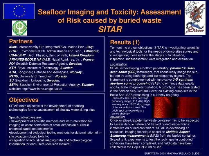
Seafloor Imaging and Toxicity: Assessment of Risk caused by buried waste SITAR. Partners ISME , Interuniversity Ctr. Integrated Sys. Marine Env., Italy ; ECAT , Environmental Ctr. Administration and Tech., Lithuania ; UBAH.PHY , Dept. Physics, Univ. of Bath, United Kingdom ;

E N D
Seafloor Imaging and Toxicity: Assessment of Risk caused by buried wasteSITAR • Partners • ISME, Interuniversity Ctr. Integrated Sys. Marine Env., Italy; • ECAT, Environmental Ctr. Administration and Tech., Lithuania; • UBAH.PHY, Dept. Physics, Univ. of Bath, United Kingdom; • ARMINES/ECOLE NAVALE, Naval Acad. res. ctr. , France; • FOI, Swedish Defense Research Agency, Sweden; • KTH, Royal Institute of Technology, Sweden; • KDA, Kongsberg Defense and Aerospace, Norway; • NTNU, University of Trondheim, Norway; • SU, Stockholm University, Sweden; • SEPA, Swedish Environmental Protection Agency, Sweden • website: http://www.isme.unige.it/sitar Results (1) To meet the project objectives, SITAR is investigating scientific and technological tools for the needs of dump-sites survey and investigation; these include the stages of localization, inspection, bioassessment, data integration and evaluation. Localization SITAR is developing a bottom penetrating parametric side-scan sonar (SSS) instrument, that acoustically image the sub-bottom by using both high and low frequency signals. The instrument is complemented with innovative 3-D synthetic aperture sonar processing (SAS), to enhance data quality and facilitate image interpretation. A prototype has been tested in the field on Sep-Oct 2003, over an existing dump site in the Baltic Sea. SAS processing is currently on-going. Inspection Once localized, a potential waste container has to be inspected to assess its true nature and hazard. Video inspection is ineffective on buried containers. SITAR is developing an acoustical imaging technique based on Multiple Aspect Scattering measurements (MAS) from the buried container. Scaled tank experiments to test the technique in controlled conditions have been completed, and field data have been collected in the Sep-Oct 2003 cruise. • Objectives • SITAR main objective is the development of enabling technologies for risk assessment of shallow water dump sites • Specific objectives are: • development of acoustic methods and instrumentation for imaging of waste containers of small dimension buried in unconsolidated sea sediments; • development of biological testing methods for determination of in-situ bioaccumulated toxicity; • integration of acoustical imaging data and biotoxicological information for end-users (decision makers). Parametric SSS data. Left: high frequency image (110 kHz) Right: low frequency (18-20 kHz) image of the same bottom area. The bright spot corresponds to a buried anomaly EUROCEAN 2004, GALWAY IRELAND, SLIDE 1
Seafloor Imaging and Toxicity: Assessment of Risk caused by buried wasteSITAR Results (2) Bioassessment SITAR efforts are focused on bioaccumulated toxicity evaluation, in contrast with traditional acute toxicity analysis. The project is developing and testing the technique of nanoinjection into fertilized fish eggs of extracts from bottom samples. The observed percentage of growth disorders, when compared with the percent disorders resulting from extracts of a known reference site, gives a relative measure of accumulated toxicity. The technique mimics maternal exposure and food uptake. It is species and pollutant independent. Analysis of samples from the study site is on-going Data integration and evaluation A GIS-based data presentation system is being developed, on specification from final end-users. The GIS system includes a Decision Support System (DSS) for buried containers image analysis and inspection. The DSS works on 3-D images from the MAS data, with tools as 3-D acoustic image segmentation, feature extraction, rendering and virtual navigation. The overall GIS system includes at the moment the historical data at the survey site, plus the first processed data made available from the Sep-Oct 2003 experiment. Relevance for society Toxic dumping at shallow water sites and in close seas has been forbidden since the London convention (1975), although it is known that covert practice has taken place, in Europe and elsewhere. Pre-London dumpings have by now undergone partial or complete burial in the seabed sediment. Even for known sites there is lack of information on amount of containers, state of preservation, environmental exposure to toxic agents. A significative (and not unique) case is the chemical munition dumping in the Baltic Sea, in the post WW-II years, where the dumping is estimated to amount to 65,000 tons of toxic warfare agents. Video inspection shows the preservation state of containers varying from totally corroded to perfectly preserved. Amount and location of buried containers is unknown. Existing technology and analysis methods are poorly efficient, if not totally uncapable, of localizing and inspect buried containers, and to measure in a realistic way the bioaccumulated toxicity in the environment due to prolonged exposure to slowly released contaminants. SITAR is providing and testing the technological and scientific tools able to cope with the present lack of means for a correct assessment of risk of buried dumpings in the seafloor. The availability of new-generation methodologies will make it feasible in a cost-effective way the systematic surveys of known and suspected dumpings. Integrated presentations will make the new data accessible in a user-friendly way to decision-makers, favouring a rational management of seabed dumping sites. Left: nanoinjected egg and fish larvae with different growth disorders; Right: SSS, bathymetry and containers density at the study site on interactive GIS map EUROCEAN 2004, GALWAY IRELAND, SLIDE 2