Download
1 / 2
20 likes | 129 Views
This paper presents an operational interferometric process for generating a Digital Terrain Model (DTM). The study was conducted by F. Hocine, M. Ouarzeddine, A. Belhadj-Aissa, M. Belhadj-Aissa, and Y. Smara from the Faculty of Electronics and Computer Science Image Processing and Radiation Laboratory at USTHB, Algiers, Algeria. The methodology includes a general flowchart involving coherence, interferometric product, coregistration, amplitude, flat earth removal, phase unwrapping, and 3D processing. The paper outlines the step-by-step procedure for generating accurate and detailed DTMs from interferometric synthetic aperture radar (InSAR) data. It highlights the significance of each stage in the process in achieving a reliable DTM.

E N D
Operational Interferometric Process for the Generation of a Digital Terrain Model F. Hocine, M.Ouarzeddine, A. Belhadj-Aissa, M. Belhadj-Aissa,, Y. Smara Faculty of Electronics and Computer Science Image Processing and Radiation Laboratory, USTHB Algiers, Algeria
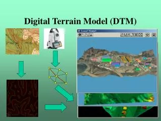
General flowchart Coherence Interferometric product Coregistration Amplitude Flat earth removal Phase unwrapping 3D