Download
1 / 1
10 likes | 164 Views
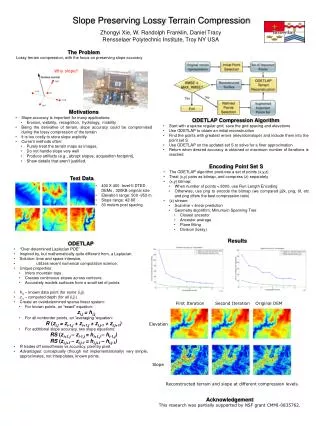
Slope Preserving Lossy Terrain Compression. Zhongyi Xie, W. Randolph Franklin, Daniel Tracy Rensselaer Polytechnic Institute, Troy NY USA. The Problem Lossy terrain compression, with the focus on preserving slope accuracy. Why slope?. Motivations

E N D
Slope Preserving Lossy Terrain Compression Zhongyi Xie, W. Randolph Franklin, Daniel Tracy Rensselaer Polytechnic Institute, Troy NY USA The Problem Lossy terrain compression, with the focus on preserving slope accuracy Why slope? • Motivations • Slope accuracy is important for many applications: • Erosion, visibility, recognition, hydrology, mobility • Being the derivative of terrain, slope accuracy could be compromised during the lossy compression of the terrain • It is too costly to store slope explicitly • Current methods often: • Purely treat the terrain maps as images, • Do not handle slope very well • Produce artifacts (e.g., abrupt slopes, acquisition footprint), • Show details that aren’t justified. • ODETLAP Compression Algorithm • Start with a sparse regular grid, save the grid spacing and elevations • Use ODETLAP to obtain an initial reconstruction • Find the points with greatest errors (elevation/slope) and include them into the point set S • Use ODETLAP on the updated set S to solve for a finer approximation • Return when desired accuracy is obtained or maximum number of iterations is reached • Encoding Point Set S • The ODETLAP algorithm produces a set of points (x,y,z) • Treat (x,y) pairs as bitmap, and compress (z) separately • (x,y) bitmap: • When number of points < 8000, use Run Length Encoding • Otherwise, use png to encode the bitmap (we compared jj2k, png, tif, etc and png offers the best compression ratio) • (z) stream: • Scanline + linear prediction • Geometry algorithm: Minumum Spanning Tree • Closest ancestor • Ancestor average • Plane fitting • Division (lossy) Test Data • 400 X 400 level-II DTED DEMs , 320KB original size • Elevation range: 500 -953 m. • Slope range: 42̊-60̊ • 30 meters post spacing Results • ODETLAP • “Over-determined Laplacian PDE” • Inspired by, but mathematically quite different from, a Laplacian. • Solution: time and space intensive, • utilizes recent numerical computation science. • Unique properties: • Infers mountain tops • Creates continuous slopes across contours. • Accurately models surfaces from a small set of points. • hi,j – known data point (for some (i,j)) • zi,j– computed depth (for all (i,j)) • Create an overdetermined sparse linear system: • For known points, an “exact” equation: • zi,j = hi,j • For all nonborder points, an “averaging “equation: • R (zi,j = zi-1,j + zi+1,j + zi,j-1 + zi,j+1) • For additional slope accuracy, two slope equations: • RS (zi+1,j – zi-1,j = hi+1,j – hi-1,j) • RS (zi,j+1 – zi,j-1 = hi,j+1 – hi,j-1) • Rtrades off smoothness vs accuracy, pixel by pixel. • Advantages: conceptually (though not implementationally) very simple, approximates, not interpolates, known points. First Iteration Second Iteration Original DEM Elevation Slope Reconstructed terrain and slope at different compression levels. Acknowledgement This research was partially supported by NSF grant CMMI-0835762.