Download
1 / 20
200 likes | 336 Views
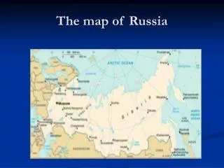
America’s Heartland: The Midwest A Primary Source Collection for “Regions of the United States” 5 th grade Teaching American History (TAH) Loudoun County Public Schools. Historical Map of the Region.

E N D
America’s Heartland:The MidwestA Primary Source Collection for “Regions of the United States”5th grade Teaching American History (TAH)Loudoun County Public Schools
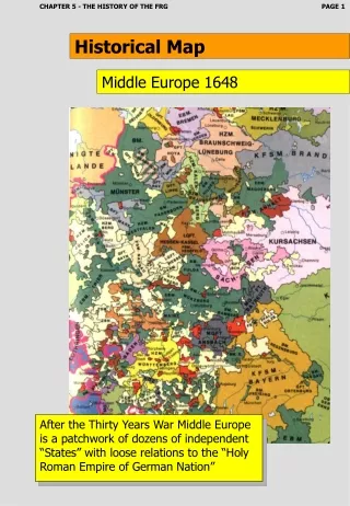
Historical Map of the Region Note that the Dakotas are still a single territory and not individual states; the map was published four years before the Battle of Little Bighorn Includes an inset map for principal products Note the presence of canals – what waterways do they connect? Kentucky is usually categorized as part of the Southeast region Note how Oklahoma and its panhandle are labeled at this time Follow the link for a zoomable version of this 1872 map of the region; available on the University of South Florida “Maps ETC” website (accessed November 14, 2012): http://etc.usf.edu/maps/pages/6600/6683/6683.htm Source: James Monteith, Comprehensive Geography (New York, NY: A. S. Barnes and Company, 1872) 40-41
Environment: The Great Lakes The Great Lakes Drainage Basin Source: U.S. Environmental Protection Agency (EPA) http://www.epa.gov/oaqps001/gr8water/xbrochure/lakes.html Drawing depicting the opening of the Illinois & Michigan Canal in 1848 – the canal connected Lake Michigan to the Illinois River and helped transform Chicago into a regional and national center for transportation and industry. Travelers could now move entirely by waterway from the Mississippi River basin to New York City on the Atlantic coast using rivers, canals, and lakes. Source: “Chicago History,” DePaul University. http://condor.depaul.edu/chicago/info_hst/earlychi.html The Canal Corridor Association provides a website that describes the history and significance of the Illinois & Michigan Canal, as well as photos of reconstructed canal boats: http://www.canalcor.org/CCA2005/CCA_Hist.html The Great Lakes Historical Society website offers helpful links to historical background and images, as well as information on the National Great Lakes Museum , scheduled to open in 2013: http://www.inlandseas.org/
The Great Lakes Today Duluth, Minnesota iron ore docks ship iron ore mined from the Mesabi Range ; see the “Minnesota Mining History” website for historic photos of mining (see the open pit mine photo below) and shipping: http://www.miningartifacts.org/IndexMinnesotaMiningHistory.html; the “Visit Duluth” website also has a brief video entitled “Seaport City” showing ships operating in the harbor area: http://visitduluth.com/duluthisopenforyou/# Photo of the Lake Erie Islands; the five Great Lakes rank among the world’s 20 largest lakes and are often described as inland seas Chicago, Illinois is the largest Great Lakes city with a population of over 2.6 million, making it the third largest U.S. city
Environment: The Central Plains 100° West longitude Pictured above: A 1907 postcard image of a steamboat near St. Louis, Missouri. Steamboats played a vital role in transporting Midwest farm goods along the Mississippi and other major rivers from the mid-1800s on into the 1900s. Source: http://steamboats.com/museum/u.html Pictured below: Iowa farm scene. The Central Plains extend from eastern Ohio to the edge of the Great Plains in the west; they are lower in elevation and receive more annual average rainfall than the Great Plains to the west of the 100°West meridian; the Mississippi, Missouri, and Ohio rivers traverse this area
Environment: The Great Plains Above: A bison herd crosses the Great Plains. Once the primary resource of Plains Indian tribes, bison herds were nearly wiped out in the buffalo hunts of the 1870s-1880s. Their near extinction helped contribute to the demise of the Plains Indians way of life, as depicted below in artist Albert Bierstadt’s The Last of the Buffalo (1888). Source: http://collection.corcoran.org/collection/work/last-buffalo The Ogallala Aquifer (depicted here in a U.S. Geological Survey map) is one of the world’s largest underground sources of water, making Great Plains farming and ranching possible. The USGS provides a site dedicated to learning about U.S. water resources at http://water.usgs.gov/.
Environment: “The Great American Desert?” While considered an important part of the nation’s “breadbasket” today, Americans in the early 1800s viewed the Great Plains as a forbidding “desert” and preferred crossing over it to make the long and dangerous trek to Oregon and California rather than attempt to settle on this virtually treeless grassland. The Oregon, Mormon, and Santa Fe trails all crossed this region. Washington Irving, in his Astoria, published in 1836, wrote: "This region which resembles one of the ancient steppes of Asia has not inaptly been termed 'The Great American Desert.' It spreads forth into undulating and treeless plains and desolate sandy wastes, wearisome to the eye from their extent and monotony. It is a land where no man permanently abides, for at certain seasons of the year there is no food for the hunter or his steed.“ Source: http://www.legendsofkansas.com/greatamericandesert.html Left: Chimney Rock, Nebraska – a major landmark on the Oregon Trail. Right: Image of Oregon Trail wagon ruts that still exist today near Rock Creek, Nebraska. Source: http://www.legendsofamerica.com/ne-overlandtrails.html Print entitled “Caravan of Emigrants for California: Crossing the Great American Desert in Nebraska” (c. 1850) Source: Library of Congress, http://www.loc.gov/pictures/item/93506241/
Environment: The Dust Bowl In the 1930s, the Great Plains witnessed one of the world’s greatest manmade ecological disasters, as a series of severe droughts struck the Midwest region. In prior decades, farmers had plowed up the native prairie grass in order to grow more wheat and other grains to meet growing world demand. With native grasses gone and crops withering in the fields, nothing remained to hold down the thin layer of topsoil, which blew away and created massive dust storms. See Ken Burns’ PBS documentary series on the Dust Bowl. http://www.pbs.org/kenburns/dustbowl/ The photographic images on this page are available on the website for Wessels Living History Farm in York, Nebraska. The website includes a description of Dust Bowl conditions as well as videotaped interviews with several Dust Bowl survivors. Source: http://www.livinghistoryfarm.org/farminginthe30s/water_01.html
Economy: Agriculture The Midwest is one of the most agriculturally productive regions in the United States. Both the “Corn Belt” and the “Wheat Belt” are located in the Midwest. The region is also one of the leading producers of soybeans in the country. The National Agricultural Statistics Service of the U.S. Department of Agriculture produces maps that show crop production by county. The map below shows the “Corn Belt” in dark green. http://www.nass.usda.gov/Charts_and_Maps/Crops_County/index.asp Technology has played a critical role in the farming history of the Midwest. Pictured above is an original John Deere steel plow (first invented in Illinois in 1837); a modern John Deere tractor and plow are pictured below. The Illinois State Museum’s exhibit on the history of Illinois agriculture provides images, background, and activities on the subject: http://www.museum.state.il.us/exhibits/agriculture/
Economy: Railroads Railroads have played a vital role in the settlement and economic development of the Midwest region since the mid-1800s. The Pacific Railroad Act, signed into law by President Abraham Lincoln in 1862, provided for the incorporation of the Union Pacific Railroad and the construction of the nation’s first railroad linking the eastern United States to the Pacific West. Building west from Council Bluffs, Iowa, the Union Pacific (UP) eventually met up with the Central Pacific line working east from California at Promontory Point, Utah in May 1869, thus creating the Transcontinental Railroad. A journey that once took pioneers nearly six months along the westward trails could now be made in six days. Today, UP is headquartered in Omaha, Nebraska and operates the nation’s largest railroad network. Above: A Chicago railroad freight yard. Left: A map depicting the progress of the Union Pacific’s construction progress in the 1860s. Below: A UP freight train Union Pacific maintains current & historical maps of its system: http://www.up.com/aboutup/reference/maps/index.htm
Economy: Meatpacking In the years following the Civil War, the meatpacking industry emerged as a major part of the nation’s economy. Ranchers shipped their beef cattle east on railroads to stockyards in cities such as Chicago, St. Louis, Kansas City, and Omaha. Several major meatpacking companies, including Swift and Armour, were headquartered in Chicago and used advertising (see the image below) to help promote the sale of meat products. Above: View of the Chicago stockyards c. 1880. Below: Slaughterhouse workers, c. 1892. Both images are from the Chicago History Museum’s online exhibit “Slaughterhouse to the World.” http://www.chicagohs.org/history/stock.html Author Upton Sinclair exposed abuses in the meatpacking industry in The Jungle, first published in 1906. Source: Library of Congress. http://www.loc.gov/teachers/classroommaterials/presentationsandactivities/presentations/branding
Economy: Manufacturing The Midwest is home to some of the most important manufacturing centers in the nation. Perhaps the most important Midwest industry is automobile manufacturing, which started in the Detroit area around 1900. The steel and tire industries have also played a critical role in Midwestern economic development. Since the 1960s, the industrial Midwest has suffered a gradual decline due to foreign competition and the movement of factories and jobs from the “Rust Belt” to the warmer states of the “Sun Belt” in the southern and western U.S. Below: Ford’s assembly line in 1913, http://www.americaslibrary.gov/es/mi/es_mi_detroit_1_e.html Henry Ford (pictured above) founded the Ford Motor Company in 1903 and began producing the Model T in 1908 using mass production techniques. Left: Ford’s River Rouge Plant in Dearborn, Michigan, c. 1930s. Right: Ford assembly line workers today. The Henry Ford Museum has an extensive collection of images and lesson plans on the auto industry at http://www.thehenryford.org/.
People: The Lakota Above: Citizenship ceremony at Fort Yates, North Dakota. The U.S. government encouraged the Lakota to assimilate as American citizens and give up their cultural identity. Citizenship rituals required that the Lakota recite an oath like the following: “_________________ (white name). What was your Indian name? (Gives name.) _________________ (Indian name). I hand you a bow and an arrow. Take this bow and shoot the arrow. (He shoots.) _________________ (Indian name). You have shot your last arrow. That means that you are no longer to live the life of an Indian. You are from this day forward to live the life of the white man. But you may keep that arrow, it will be to you a symbol of your noble race and of the pride you feel that you come from the first of all Americans…” Source: http://www.ndstudies.org/resources/IndianStudies/standingrock/docs_citizenship.html The Lakota (Sioux) of the north central plains region attempted to retain their independence in the face of westward settlement and U.S. policies that eventually forced them on to reservations in the Dakotas. Their leaders, such as Sitting Bull (pictured above left), challenged U.S. treaty violations and successfully confronted the U.S. military at the Battle of Little Bighorn in 1876 (aka, “Custer’s Last Stand” pictured above right). However, this victory was short-lived, as the Lakota were eventually forced to accept life on reservations operated by the U.S. government. In 1890, the so-called “battle” of Wounded Knee in South Dakotaresulted in a massacre of Lakota (pictured right) and represented the last violent confrontation between Native Americans and the U.S. government. Click on photos for Library of Congress links.
Wounded Knee After being forced on to reservations by the late 1880s, Native Americans across the West responded to the call of Wavoka, a Pauite mystic known as “the Messiah”, to revive Native American traditions through the Ghost Dance ritual. Wavoka’s prophecy that a day would soon come when the white man would disappear and the buffalo would return gave hope to a desperate people. However, the Ghost Dance movement also created concern that Native Americans were planning a general uprising against U.S. authority. Increasing tensions led to the massacre of Lakota at Wounded Knee. The picture below from The Illustrated London News of January 3, 1891, depicts a Ghost Dance ceremony. Source: http://www.loc.gov/pictures/item/2006681363/ The Lakota leader, Bigfoot, thought he was leading his people to safety when they entered the Pine Ridge Reservation in December 1890. Instead, they were attacked and massacred by soldiers. The following ballad was composed by Private W.H. Prather, an African-American cavalryman, to commemorate the military’s actions at Wounded Knee. This source and the photo of Bigfoot’s frozen corpse above are from the PBS website for The West, which also has an archive of documents and images related to the Lakota: http://www.pbs.org/weta/thewest/resources/archives/ “The Red Skins left their Agency, the Soldiers left their Post,All on the strength of an Indian tale about Messiah's ghostGot up by savage chieftains to lead their tribes astray;But Uncle Sam wouldn't have it so, for he ain't built that way.They swore that this Messiah came to them in visions sleep,And promised to restore their game and Buffalos a heap,So they must start a big ghost dance, then all would join their land,And may be so we lead the way into the great Bad Land. Chorus:They claimed the shirt Messiah gave, no bullet could go through,But when the Soldiers fired at them they saw this was not true.The Medicine man supplied them with their great Messiah's grace,And he, too, pulled his freight and swore the 7th hard to face…”
The Homestead Act of 1862 opened up western lands in the Plains region to farm families in the late 1800s. Homesteaders could obtain up to 160 acres of land for a $10 registration fee and proof of residence. Railroad companies also sold land to prospective farmers and profited from storing their grain and shipping their produce to market. The image pictured to the right is an 1872 railroad company ad aimed at enticing prospective land owners. Source: Library of Congress. http://hdl.loc.gov/loc.rbc/rbpe.13401300) People: Homesteaders The photo above is of the Bakken family standing in front of their sod house near Milton, North Dakota, c. 1895; from the Fred Hulstrand History in Pictures Collection available at the Library of Congress website: http://memory.loc.gov/ammem/award97/ndfahtml/hult_home.html
Laura Ingalls Wilder Perhaps no homesteader is more famous than Laura Ingalls Wilder, the credited author of the famous “Little House” series of eleven books published between 1932 and 1974. The books recount Laura’s childhood and early adulthood in the late 1800s and provide a firsthand glimpse of the challenges of living on the Midwestern frontier, from the north woods of Wisconsin to the plains of Kansas, Minnesota, and South Dakota. After moving many times around the country and experiencing great financial and physical hardships, Laura and her husband, Almanzo, settled in the Missouri Ozarks in 1894 and remained there until their deaths – Almanzo in 1949 at the age of 92 and Laura in 1957 at the age of 90. Their daughter, Rose Wilder Lane, an accomplished writer, likely had a hand in helping to author her mother’s books. By the 1970s, the “Little House” series had achieved widespread national popularity and inspired the long-running Little House on the Prairie television series (pictured above). For background and primary resources on Laura Ingalls Wilder, check out the following sites: http://www.liwfrontiergirl.com/ http://lauraingallswilderhome.com/ The National Archives also has a collection of documents related to Charles Ingalls’ (Laura’s father) homestead claims: http://www.archives.gov/research/land/ingalls/index.html
People: Immigrants Midwestern cities and rural areas attracted a growing number of immigrants in the late 1800s and through the 20th century. Large numbers of Germans and Scandinavians settled the north central plains and a diverse mix of European immigrants helped to create a “melting pot” of cultures in large cities such as Chicago. The Chicago Historical Society’s “The History Files” has resources on topics such as the Chicago Fire of 1871: http://www.chicagohs.org/history/index.html Below Left: 1916 aerial view of Chicago. Source: http://www.worldmapsonline.com/historicalmaps/1W-IL-C3-1916.htm Pictured above left: Social reformer Jane Addams founded Hull House in 1889 on Chicago’s southwest side. The institution was America’s first “settlement house” designed to help newly-arrived immigrants adapt to urban American society. The University of Illinois - Chicago has created a web site on Hull House and the immigrant experience in Chicago that provides helpful background and multiple primary source documents: http://www.uic.edu/jaddams/hull/urbanexp/ Above: Photograph of the Pettersens, a Norwegian immigrant family, in front of their farm home near Lodi, Wisconsin, c. 1870; from photographer Andreas Larsen Dahl’s collection; available on the Wisconsin Historical Society’s website: http://wiscohisto.tumblr.com/post/35638753045/the-pettersen-family-in-front-of-their-home-lodi
People: The Great Migration U.S. involvement in the world wars of the early 1900s increased the demand for industrial labor in Northern factories, including those of the Midwest. The lure of jobs and new economic opportunities drew thousands of African-American families from the rural South to Midwestern cities such as Chicago, Detroit, and Cleveland. The “Great Migration” resulted in the establishment of large African-American communities in areas such as Chicago’s “South Side” and the emergence of a vibrant culture in which blues and jazz music played a central role. The Library of Congress online exhibit entitled “Chicago: Destination for the Great Migration” includes related maps, photos and letters: http://www.loc.gov/exhibits/african/afam011.html Above: African-American family photographed arriving in Chicago, c. 1919, from BlackPast.org, an online resource for African-American history developed by Dr. Quintard Taylor of the University of Washington. http://www.blackpast.org/?q=aah/great-migration-1915-1960 Right: Jacob Lawrence’s Great Migration, published in 1940, is a collection of Lawrence’s paintings inspired by the experiences of African-American families and includes a foreword by the author, as well as the poem “Migration” by Walter Dean Myers.