Download
1 / 31
310 likes | 441 Views
Preliminary Review of Sediment TMDL GIS Database. Imperial Valley Spatial Data Infrastructure Project. Meeting Objectives. Redlands Institute: Recap of Project Objectives and Process Review Preliminary GIS Database Review prototype web-based tools Document your feedback Participants:

E N D
Preliminary Review of Sediment TMDL GIS Database Imperial Valley Spatial Data Infrastructure Project
Meeting Objectives Redlands Institute: • Recap of Project Objectives and Process • Review Preliminary GIS Database • Review prototype web-based tools • Document your feedback Participants: • Provide comments on the design, content and end user functionality of the system • Possible one-on-one meetings to implement suggested changes
Project Objectives • Develop GIS database and tools that support non-point source pollution management in the Imperial Valley • Primarily for Sediment TMDL implementation • Recognize that the GIS could benefit science/research community as well
Conduct orientation seminar Imperial Valley SDI Project Tasks Conduct needs assessment and requirements analysis Develop TMDL Geodatabase Develop Web-based Application Develop TMDL Analysis Tools and Models Final Reports Future Data Collection and Analysis Techniques Prepare Outreach Materials and Support
What is Spatial Data Infrastructure? SDI as a principle recognizes GIS data as a fundamental infrastructure component for national or regional development SDIs are built around ‘communities’ with a common interest/objective and use the internet to share ‘fundamental’ information and tools Users access SDI resources (GIS databases, models, outreach materials) through a web browser Institutional policies, procedures and standards to manage how information is shared/used is critical to long term success
Anticipated Outcomes More efficient use of existing information Increased use of monitoring and related data for NPS management/research Better data access/quality Standard methods for collecting, formatting and reporting water quality related data Policies and procedures to guide how data is collected, shared and used
Database Development Process Stakeholder Survey • Bureau of Reclamation • Department of Pesticide Regulation • California Department of Water Resources • State Water Resources Control Board • Imperial County Agricultural Commission • Imperial County Farm Bureau • Imperial Irrigation District • International Boundary and Waters Commission • Regional Water Quality Control Boards (3, 5, 7) • Salton Sea Authority • University of California Davis Cooperative Extension
Database Development Process Stakeholder Survey Data Inventory and Assessment Over 300 Unique Datasets Identified
Database Development Process Stakeholder Survey Data Inventory and Assessment Reformatting data for GIS Coding flow direction Data Compilation/ Conversion Fixing errors in spatial data Water quality data index Creating basic metadata
Database Development Process Stakeholder Survey Data Inventory and Assessment Data Compilation/ Conversion Database design review Physical Design Conceptual Design Database Design/ Development
Database Development Process Stakeholder Survey Data Inventory and Assessment Load Duration Curves Data Compilation/ Conversion Time Series Animations TSS and Turbidity Trends Database Design/ Development GIS Database Poster Analysis and Visualization Products Statistical analysis of BMP-TSS relationships
Web-based GIS Stakeholder Survey Planned/ Potential Functions Current functions Data Inventory and Assessment Data upload/ format crosswalk Upstream/ downstream tracing Data Compilation/ Conversion Semi-automated QC Scroll-over display of key information Database Design/ Development Additional map and report types Customized reports/maps Analysis and Visualization Products Spatial analysis tools Spatial data select Web-based GIS Statistical analysis tools Data download
GIS Database Orientation Serene Ong
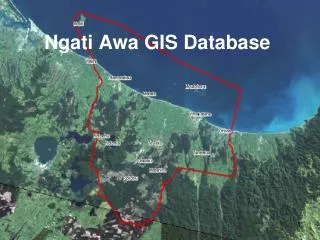
Database Design Objectives • Create a sediment TMDL geospatial database • Improve on the USGS National Hydrography Dataset (NHD) data • Incorporate local data from various agencies • Support better analysis of water quality and land management practices • Comply with the State Water Resources Control Board (SWRCB) Surface Water Ambient Monitoring Program (SWAMP) standards
Sediment TMDL • Related Data • Total Suspended Solids (TSS), Turbidity, Monitoring locations (R7, IID, BOR) • Surface Hydrology Network (NHD, IID) • Agricultural Practices (ICFB Farm Reports) • Drainsheds, Farm Plots (RI) • Land ownership boundaries • Owner/operator data (ICTA, IID)
Process of making a database compliant • Obtaining the data • Processing the data • Coding flow direction, Changing field names and data types so they fit into SWAMP standard fields and data types • Crosswalk data from various tables • Include all required SWAMP tables and fields • Create links between tables
SWAMP Crosswalk table - Tables and Fields
SWAMP Crosswalk table - Relationship Classes
Agricultural Practice Data From Imperial Country Farm Bureau : • Best Management Practices • Site Conditions • Crop Type • Landowner data • Drainshed • Canal name • Gates
Schema diagram Cadastral - Owner - Operator Hydrology Network Features Water Quality Analysis Agricultural Practices
Web-based GIS tools Nate Strout
Brainstorm Focus • What additional data and end-user functionality would you like to see?
Next Steps Process for data update and maintenance Policies for data sharing/ reporting and security Web-GIS deployment/ testing Web-based GIS and TMDL analysis tools Outreach/ training materials Feedback and refinement of draft GIS Training and hand-over to long-term steward Document future data and analysis needs