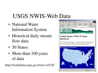
USGS NWIS-Web Data
USGS NWIS-Web Data. National Water Information System Historical daily stream flow data 50 States More than 100 years of data. http://waterdata.usgs.gov/nwis-w/US/. Beginning Date. Output Format. State. Station ID. End Date. NWIS-W URL Interpretation.

USGS NWIS-Web Data
E N D
Presentation Transcript
USGS NWIS-Web Data • National Water Information System • Historical daily stream flow data • 50 States • More than 100 years of data http://waterdata.usgs.gov/nwis-w/US/
Beginning Date Output Format State Station ID End Date NWIS-W URL Interpretation http://waterdata.usgs.gov/nwis-w/TX/data.components/hist.cgi?statnum=08159000&bdate_month=03&bdate_day=23&bdate_year=1976&edate_month=09&edate_day=30&edate_year=1999&graphsize=1.5&mode=data&dateformat=0
NWIS-W Data • Metadata • Tabular Output • Year.Month.Day • Discharge (cfs)
Selecting Gages • Place flag at P.O.I. • Trace Upstream • Select Gages by Location • Press Smiley Face
Choosing the Dates • Input Start and End Date • Input State
The Finished Product • Output Message • Tables added to Map Document