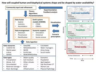

GROUND-WATER AVAILABILITY
E N D
Presentation Transcript
GROUND-WATER AVAILABILITY Planning for Sustainable Future Water Supplies South of the C&D Canal Delaware Geological Survey – January 2007
OVERVIEW • CONCEPTS • HISTORICAL PERSPECTIVE • CURRENT STATUS • PLANNING FOR THE FUTURE Delaware Geological Survey – January 2007
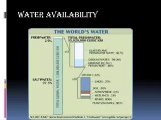
MAJOR CONCEPTS • Ground water is the only naturally occurring source for fresh potable water • Desalinization is very expensive • Surface water is not an option Delaware Geological Survey – January 2007
MAJOR CONCEPTS • GW can not be directly observed • Aquifers supply water to wells • GW is connected to SW • Coastal Plain geology controls Q&Q • There is a lot of water, but • not always where we need it • not of the right chemical quality • “Sustainability” is a time-relative value judgement Delaware Geological Survey – January 2007
MAJOR CONCEPTS • There is a lot of good information available, but • not always where we need it • of the right type • Increased demand for aquifers to be used for wastewater and stormwater disposal, and ASR • Reliable estimates of availability use all available data in an appropriate model and are presented as a range of values Delaware Geological Survey – January 2007
HISTORICAL PERSPECTIVE OF GROUND-WATER AVAILABILITY STUDIES 1950’s – 1960’s • Simple water budgets • Analytic equations with gross assumptions • Regional scale • Limited data – few dozen to few hundred observation points • Identification of aquifer/geologic units hampered by lack of data Delaware Geological Survey – January 2007
HISTORICAL PERSPECTIVE OF GROUND-WATER STUDIES 1970’s – 1990’s • Availability determined from simple water budget and analytic models • A few more complex numerical models of limited areal scope were constructed • Local to regional studies • Focused data collection by topic or geography • Most aquifer units identified with modern data and terminology
HISTORICAL PERSPECTIVE OF GROUND-WATER STUDIES 2000 to present • Local to regional studies • More complex numerical models for specific problems • Multiple large datasets of hydrogeologic conditions and infrastructure • Focus of projects is to provide numerical data suitable for use in detailed ground-water flow models • Identify where aquifers are connected Delaware Geological Survey – January 2007
CURRENT PROJECTS • Domestic well water quality – (DCC) • Confined aquifers in KC • Aquifer thickness in KC • KC surficial geologic map • Database development and upgrades • USACE steady state model of NNCC • TMDL efforts Delaware Geological Survey – January 2007
WHERE WE ARE GOING • Many cooperators • SNCC confined aquifers • Automation of gw, sw, and climate measurements • KC transmissivity • SC confined aquifers ….. • SC surficial geologic map Delaware Geological Survey – January 2007
C&D Canal Key ground-water recharge areas are located where aquifer units intersect the unconfined aquifer - SNCCo example Unconfined + Mt. Laurel aq. Unconfined + Mt. Laurel Unconfined, Mt. Laurel + Rancocas aq WF 2 Middletown Unconfined + Rancocas aq. 0 5 Scale In miles Delaware Geological Survey – January 2007
Hydraulics of Unconfined Aquifer and intersection with Manokin Aquifer – Sussex Co. Base and transmissivity of unconfined aquifer Top of Manokin aquifer N Delaware Geological Survey – January 2007
QUANTITY Poorly constrained estimates of gw availability Streamflow depletion Wastewater, stormwater, and ASR Declining gw levels in confined aquifers QUALITY Widespread contamination SW impacts of gw contamination Wastewater, stormwater, and ASR MOVING TO SOLVE PRIORITY PROBLEMS:THE TWO Qs Q available <> Q sustainable ?? Delaware Geological Survey – January 2007
NEEDS FOR WATER SUPPLY PLANNING • Better tools and information to more effectively manage and plan …… • Basic data measurements – levels, flow, hydraulics, and chemistry • Improved pumping data • Numerical flow simulation based estimates – steady state then transient • 10 year life cycle of model tools Delaware Geological Survey – January 2007
SUSTAINABLE DEVELOPMENT STUDY COMPONENTS • Aquifer characterization (geometry& hydraulics) • GW levels, stream discharge (localized) • Characterize water use at appropriate time scales (pumping and disposal) • Linkage to SW models and TMDL issues Delaware Geological Survey – January 2007
RIBS/Stormwater/ASRStudy Components • Phased investigation • Pre-treatment • Hydraulics and modeling • Field performance • Geochemistry/Contaminant transport • Stream/well impacts Delaware Geological Survey – January 2007
WHAT ELSE IS NEEDED FOR PLANNING ?DISCUSS PRIORITY AREAS AND DEVELOP A WORK PLAN AND SCHEDULE • Southern NCC/Northern KC • Eastern SC • Central to southern KC • Northern NCC • Western SC • Impact of wastewater on water supply Delaware Geological Survey – January 2007
EXPLORATIONSTUDY COMPONENTS • Test drilling and lithologic characterization of geologic units • Multi-level wells and characterization of hydraulic and chemical properties of aquifers (Spatial distribution of 10,000 mg/L TDS in Potomac aquifers in SNCC and NKCo; Cheswold and deeper in ESC) • Depths > 2500 ft Delaware Geological Survey – January 2007