Download
1 / 52
580 likes | 1.09k Views
The United Nations Convention on the Law of the Sea and the Delineation of the Outer Limits of the Continental Shelf. Harald Brekke CLCS Member. UN PROCESS. International Law Commission 1949 - 1956 1 st Conference on the LOS 1958 - Geneva Convention 1958

E N D
The United Nations Conventionon the Law of the Sea and the Delineation of the Outer Limits of the Continental Shelf Harald Brekke CLCS Member
UN PROCESS International Law Commission 1949 - 1956 1st Conference on the LOS 1958 - Geneva Convention 1958 2nd Conference on the LOS 1960 Sea-Bed Commission 1968 - 1973 Declaration of Principles, GA 1970 3rd Conference on the LOS 1973 - 1982 - UNCLOS 1982 - Entered into force 1994
UNITED NATIONS CONVENTION ON THE LAW OF THE SEA Maritime zones of jurisdiction
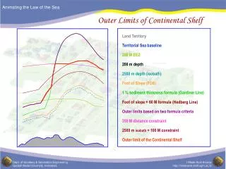
Maritime zones of jurisdiction LIMIT OF THE CONTINENTAL THE AREA CONTINENTAL SHELF BEYOND 200 M SHELF 200 - MILE BOUNDARY SLOPE CONTINENTAL FOOT OF THE 200 M EXCLUSIVE ECONOMIC ZONE (EEZ)) CONTIGUOUS ZONE 24 M 12M TERRITORIAL SEA BASELINE LAND LAND RG 31.1.00 R 001070
TRUMAN PROCLAMATION 28 SEPT. 1945 The Government of the United States ”...regards the natural resources of the subsoil and seabed of the continental shelf beneath the high seas but contiguous to the coasts of the United States as appertaining to the United States, subject to its jurisdiction and control.” United States Government regarded this to be”... reasonable and just, .............., since the continental shelf may be regarded as the extension of the landmass of the coastal nation and thus naturally appurtenant to it .”
INTERNATIONAL COURT OF JUSTICE 20 FEB. 1969 “More fundamental than the notion of proximity appears to be the principle ...... of the natural prolongationorcontinuationof the land territory..... “ .. What confers the ipso jure title which international law attributes to the coastal State in respect of its continental shelf, is the fact that the submarine areas concerned may be deemed to be actually part of the territory over which the coastal State already has dominion , - in the sense that, ..... , they are a prolongation or continuation of that territory,...”
CONTINENTAL SHELF BOUNDARIES Geneva Convention 1958: The continental shelf extends “..to where the depth of the superjacent water admits of the exploitation of the natural resources..” UNCLOS 1982: The limits of the continental shelf established according to the Convention “..shall be final and binding”
Sketch of geological principles Continental margin Continental Shelf Continental Mid - oceanic Footofslope ridge slope Sediments Continental Deepoceanfloor rise 6-15 Km Oceanic crust 30 - 50 Km Krystallinsk kontinental skorpe Crystalline continental crust Melted mantle Earth's mantle MHe 13.12.99 RL9909003/6
UNITED NATIONS CONVENTION ON THE LAW OF THE SEA PART VI CONTINENTAL SHELF ARTICLE 76 Definition of the continental shelf
Article 76, paragraph 1 “The continental shelf of a coastal State comprises the sea-bed and the subsoil of the submarine areas that extend beyond its territorial sea throughout the natural prolongation of its land territory to the outer edge of the continental margin, or to a distance of 200 nautical miles from the baselines from which the breadth of the territorial sea is measured where the outer edge of the continental margin does not extend up to that distance.”
Paragraph 1 Defines the continental shelf in terms of the outer edge of the continental margin. This is a legal definition and must not be confused with the scientific definition.
Paragraph 1 The continental shelf extends either: to the outer edge of the continental margin or: to 200 nautical miles where the continental margin does not extend that far
The continental shelf - juridical vs scientific concept Continental shelf (juridical) Continental margin Continental Shelf (scientific) Continental Mid - oceanic Foot of slope ridge slope Sediments Continental rise Deep ocean floor Oceanic crust 6-15 Km 30 - 50 Km Krystallinsk kontinental skorpe Crystalline continental crust Melted Earth's mantle mantle 0 100 200 Nautical miles (M) MHe 13.12.99 RL9909003/6
Paragraph 1 The continental shelf comprises the sea-bed and subsoil (the superjacent water is not included)
Article 76, paragraph 3 “The continental margin comprises the submerged prolongation of the land mass of the coastal State, and consists of the sea-bed and the subsoil of the shelf, the slope and the rise. It does not include the deep ocean floor with its oceanic ridges or the subsoil thereof.”
Paragraph 3 Defines the continental margin by: Specifying its physical components and Specifically excluding adjacent features
Article 76, paragraph 3 Coastal State Sea Surface Shelf Land mass Slope Foot of slope Rise Deep ocean floor Continental margin
Paragraph 3 The definition of the continental margin is neutral regarding the geological nature of the underlying earth’s crust. The continental margin is defined in terms of the prolongation of the landmass of the coastal State
The Coastal State Origin According to paragraphs 1 and 3 the coastal State is the starting point for the continental margin, and generates its continental shelf: The continental margin is the submerged prolongationof its landmass (§ 3), while The continental shelf is the sea-bed and subsoil of the natural prolongationof its land territory (§ 1).
Article 76, paragraph 2 “The continental shelf of a coastal State shall not extend beyond the limits provided for in paragraphs 4 to 6.”
Article 76, paragraph 4 Gives operational definitions of the outer edge of the continental margin (§4(a)) and the foot of the continental slope (§4(b)).
Article 76, paragraph 4 a) “For the purposes of this Convention, the coastal State shall establish the outer edge of the continental margin wherever the margin extends beyond 200 nautical miles from the baselines from which the breadth of the territorial sea is measured, by either:
Article 76, paragraph 4 a) (i)a line delineated in accordance with paragraph 7 by reference to the outermost fixed points at each of which the thickness of sedimentary rocks is at least 1 per cent of the shortest distance from such point to the foot of the continental slope; or
Article 76, paragraph 4 a) (ii)a line delineated in accordance with paragraph 7 by reference to fixed points not more than 60 nautical miles from the foot of the continental slope.”
Determination of the outer edge of the continental margin Baseline Foot of slope Sediments 60M 1 % of distance to foot ofslope Crystalline continental crust Oceanic crust Nautical mile( M ) 0 100 200 300 400
Continetal margin delineationBathymetric map 2350 2000 2100 2300 2550 2500 2000 1700
Article 76, paragraph 4 b) “In the absence of evidence to the contrary, the foot of the continental slope shall be determined as the point of maximum change in gradient at its base.”
Determination of correct foot of slope Sketch of geological principles Continental margin Continental Shelf OUTER Foot of slope PLATEAU Continental Mid - oceanic slope ridge Sediments Continental EROSJONS- rise Deep ocean floor DAL Oceanic crust 6-15 Km 30 - 50 Km Crystalline continental crust Melted Earth's mantle mantle MHe 13.10.99 RL9909003/5
Paragraph 5 Sets the maximum extent of the continental shelf to be either: 350 nautical miles from the baselines or: 100 nautical miles from the 2,500 meters depth contour
Maximum limits of the continental shelf Baseline Maximum 1 Maximum 2 2500 m isobath 100M Foot of slope Sediments 60M 1 % of distance to foot ofslope Crystalline continental crust Oceanic crust Nautical mile( M ) 0 100 200 300 400 350
Continetal margin delineationBathymetric map 2350 2000 2100 2300 2550 2500 2000 1700
Continetal margin delineationBathymetric map 2350 2000 2100 2300 2550 2500 2000 1700
Continetal margin delineationBathymetric map 2350 2000 2100 2300 2550 2500 2000 1700
Categories of submarine highs Oceanic ridges of the deep ocean floor - § 3 Submarine ridges - § 6 Submarine elevations that are natural components of the continental margin - § 6
Paragraph 6 Maximum limits on submarine highs: “Submarine ridges” - 350 M “Submarine elevations” - § 5 applies
STATEMENT OF UNDERSTANDING CONCERNING A SPECIFIC METHOD TO BE USED IN ESTABLISHING THE OUTER EDGE OF THE CONTINENTAL MARGIN Final Act - Annex II
Final Act - Annex II A request from the Third Conference to the CLCS to let itself be governed by a set of special rules for thecoastal States in the southern part of the Bay of Bengal. These rules aim to compensate for the exceptional shape and sediment distribution of the continental margin in this region.
Paragraph 7 States that the outer limit of the continental shelf beyond 200 nautical miles shall be delineated by: fixed points not more than 60 nautical miles apart, and straight lines connecting the fixed points.
Article 76, paragraph 8 "Information on the limits of the continetal shelf beyond 200 nautical miles (.......) shall be submitted to the Commission on the Limits of the Continental Shelf (.....)."
Article 76, paragraph 8 (continued) "The Commission shall make recommendations to coastal States on matters related to the establishment of the outer limits of their continental shelf."
Article 76, paragraph 8 (continued) "The limits of the shelf established by a coastal State on the basis of these recommendations shall be final and binding."
Article 76, paragraph 9 "The coastal State shall deposit with the Secretary-General of the United Nations charts and relevant information, including geodetic data, permanently describing the outer limits of its continental shelf. The Secretary-General shall give due publiscity thereto."
Article 76, paragraph 10 “The provisions of this article are without prejudice to the question of delimitation of the continental shelf between States with opposite or adjacent coasts.”
Article 77Rights of the coastal state over the continental shelf Provides for the coastal State sovereign rights over the continental shelf for the purpose of exploring and expoliting its natural resources. These rights are exclusive and do not depend on occupation, effective or notional, or on express proclamation.
Article 82Payments and contributions with respect to the expolitation of the continental shelf beyond 200 nautical miles - Coastal State to make payments or contributions in kind to the International Seabed Authority - 1% from sixth year increasing annually to 7% (max) of value or volume of production at site - Developing States who are net importers of a mineral resource produced from it continental shelf are excempted