Download
1 / 27
320 likes | 732 Views
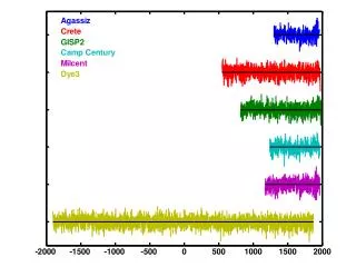
Beaches of Glacial Lake Agassiz. Ben Huffman Ashley Russell. Appearance. Old beaches are traceable Continuous, smoothly rounded ridge Most lie 3-10 feet above till side, and 10-20 above lake side Variations in height are due to unequal currents and wave power

E N D
Beaches of Glacial Lake Agassiz Ben Huffman Ashley Russell
Appearance • Old beaches are traceable • Continuous, smoothly rounded ridge • Most lie 3-10 feet above till side, and 10-20 above lake side • Variations in height are due to unequal currents and wave power • Some beaches are cut through from old streams • Marked by gravel and sand sloping into water level and till • Provide strong evidence for the existence of glacial lakes
Formation • Storm waves moved gravel and sand from erosion of till deposits transported into Lake Agassiz • Fines settled to the middle of the lake • Interactions with wind, waves, and currents formed bars, spits, hooks, loops and terraces • Best preserved on moderate slopes. • Successions of beaches can mark pauses in uplift after ice retreat, subsidence with outlet erosion, and lowering of lake levels with new discharge routes
These locations marked in red have well preserved beach ridges from many stages of Lake Agassiz. Beach ridges can be described through Minnesota, North Dakota, and Manitoba.
Beach Successions • There are many beaches that describe the levels of Agassiz through time. • The main ones are as follows (starting with the oldest and highest): • Herman Beaches • Minnesota Beaches • Norcross Beaches • Tintah Beaches • Campbell Beaches • McCauleyville Beaches Associated with south outflow
Beach Successions (cont.) • Blanchard Beaches • Hillsboro Beaches • Emerado Beaches • (2 main series) • Ojata Beaches • (2 main series) • Gladstone • Burnside • Ossowa • Stonewall • Niverville • (2 main series) • The amount of beach ridges associated with each set varies from place to place. Associated with Lake Agassiz northeast outlet
Herman Beaches • Uppermost beaches • Doubles in northern part of Agassiz • Gravel with pebbles 2-3 inches in diameter • Highest stand of Agassiz at 1,055 feet above sea level • Some places show the Milnor stage • Stands about 20 to 30 feet above the Herman • Records that the River Warren outlet was higher for a short time
Associated with South Outlet • Minnesota, Norcross, Tintah, Campbell, and McCauleyville beaches • Hard to match with northern beaches due to the progression of Agassiz to the north. • Campbell stage is the most conspicuous below the Herman • Shows Agassiz at a much lower level • Sand and gravel swept southward from the Pembina Delta • McCauleyville beaches show that the outlet from Agassiz eroded below Lakes Traverse and Big Stone
Associated with NE outlet • 14 total shorelines • Lie below the McCauleyville • River Warren was no long receiving drainage from ice, and thus Agassiz obtained a lower NE outlet • Beach sets are separated by 10-45 ft. • Blanchard stages are the oldest • Show three levels or three pauses in uplift • Hillsboro beaches show spits formed from currents associated with the fall of lake level • Emerado beaches are very traceable, and only have one beach in MN and ND, and two beaches in Manitoba • Niverville Beaches show 2 or 3 stages, caused by northward uplifting of land.
Timing and Epeirogenesis • Epeirogeny - Uplift or depression of the Earth's crust. • Relationship • Lake levels are associated with the outlet level • Rebound contributed to outlet shifts
Epeirogenic Dependence • It has been estimated that the lake bottom of Lake Winnipeg may have only been about 100 feet above sea level. • Now it is ~ 600ft above sea level • Elevation changes were affecting lake outlets. • Talk overlap.
Epeirogenic Dependence • Today we see shorelines that must have been level at one time, but now display vertical changes in elevation. • South to North • Elevation change show some latitude dependents
Take away • Beaches are dependent on Lake level which are dependent on outlet elevation. • Epeirogenesis was a driving factor is shifting lake outlets • Measurements of uplift can be attained by measuring vertical change in beaches
Sources • Teller, J.T., and Clayton, L., 1983, Glacial Lake Agassiz, The Geological Association of Canada, Special Paper 26. • Thorleifson, L.H., 1996, Review of Lake Agassiz History, Geological Survey of Canada. • Upham, W., 1895, Glacial Lake Agassiz, U.S. Geological Survey, Monographs XXV.