Download
1 / 37
370 likes | 530 Views
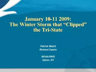
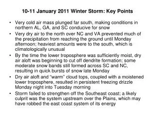
10-11 January 2011 Winter Storm: Key Points. Very cold air mass plunged far south, making conditions in northern AL, GA, and SC conducive for snow

E N D
10-11 January 2011 Winter Storm: Key Points • Very cold air mass plunged far south, making conditions in northern AL, GA, and SC conducive for snow • Very dry air to the north over NC and VA prevented much of the precipitation from reaching the ground until Monday afternoon; heaviest amounts were to the south, which is climatologically unusual • By the time the lower troposphere was sufficiently moist, dry air aloft was beginning to cut off dendrite formation; some moderate snow bands still formed across SC and NC, resulting in quick bursts of snow late Monday • Dry air aloft and “warm” cloud tops, coupled with a moistened lower troposphere, resulted in persistent freezing drizzle Monday night into Tuesday morning • Storm failed to strengthen off the Southeast coast; a likely culprit was the system upstream over the Plains, which may have robbed the east coast system of its energy
06 UTC Monday Strongly negative AO/NAO with the polar jet displaced far to the south Long-wave trough to the west with short-wave trough moving through the Deep South
12 UTC Monday Snow is reaching the ground in GA and SC by early Monday morning
Very dry air mass over mid-Atlantic, VA, and NC prevents snow from reaching the ground
00 UTC Monday: GSO Cold, dry column at GSO before event begins
00 UTC Monday: BMX Warm nose and FZRA at Birmingham early in the event
00 UTC Monday: FFC Narrow warm nose and sleet at Atlanta
1628-1748 UTC Monday Dry air to the north eroding the leading edge of precipitation in central NC
1815 UTC Monday Dry slot moving across the Deep South is cutting off moisture in the dendritic growth zone
2138 UTC Monday “Banded” structure to the precipitation across the Carolinas
21 UTC Monday Snow begins to reach the ground in central NC
00 UTC Tuesday 700 mb Southwesterly flow at 700mb helps warm up the low-levels
Dry air aloft (above 700 mb) beginning to starve the dendritic zone of moisture
06 UTC Tuesday Freezing drizzle overnight in central NC due lack of dendrites, “warm” cloud tops, and moist lower troposphere
Did the upstream long-wave trough steal some of this storm’s energy???
06 UTC Tuesday 1 2 1 and 2 above correspond to the soundings on the next slides
Note the dramatic subsidence inversion and 1000-500 mb thickness values! 1