Lifecycle Management Work Group
190 likes | 211 Views
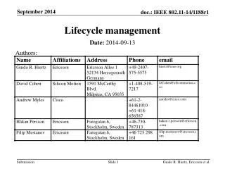
A presentation on Lifecycle Work Group Deliverables By Wendy Blake-Coleman (USEPA) Dennis Crow (USDA) Dave LaBranche (representing DOD) Michael Lee (USGS / DHS) Jeff Booth (representing DOE) Tom Chatfield (BLM). Lifecycle Management Work Group. Briefing Purpose.

Lifecycle Management Work Group
E N D
Presentation Transcript
A presentation on Lifecycle Work Group Deliverables By Wendy Blake-Coleman (USEPA) Dennis Crow (USDA) Dave LaBranche (representing DOD) Michael Lee (USGS / DHS) Jeff Booth (representing DOE) Tom Chatfield (BLM) Lifecycle Management Work Group
Briefing Purpose • Present overview of Geospatial LoB Lifecycle Management Work Group goals and products • Provide summary of activities within each Lifecycle Management Work Group subgroup • Obtain approval of approach outlined in the Geospatial Data Lifecycle Stages Matrix • Discuss next steps and FGDC Coordination Group involvement
Lifecycle Management Work Group Structure Lifecycle Management Work Group has 30 members from 10 Federal Departments and Independent Agencies Work Group Lead: Wendy Blake-Coleman, EPA Include representatives from both geospatial data-producing and geospatial data-using agencies Work Group includes three sub-groups OMB Circular A-16 Definitions: Dennis Crow, USDA, Lead Theme Content: Michael Lee, USGS / DHS, and David LaBranche, DOD, Co-Leads Lifecycle: Jeff Booth, DOE, and Tom Chatfield, BLM, Co-Leads
Lifecycle Management Work Group Activities Evaluating “as-is” state of OMB Circular A-16 and impact on theme/dataset portfolio management Definitions Management and reporting responsibilities Scope Drafting improvement strategy forA-16 portfolio management which includes supplemental OMB circular A-16 guidance Providing more precise operational definitions Defining nationally significantthemes / datasets Creating criteria to add, delete, or consolidate themes/datasets Incorporating the entire lifecycle management practices into portfolio management Identifying opportunities for efficient data development
Goal to Provide FGDC Coordination Group with a suite of processes to: Track and evaluate progress for completing the NSDI Make recommendations to the FGDC Steering Committee on: Setting priorities for cross government partnerships Amending the management or composition of themes / data under OMB Circular A-16 Encouraging data development efficiencies Lifecycle Management Work Group Activities
Outline of Proposed OMB Circular A-16 Supplemental Guidance • Introduction • Purpose and Authority • Definitions, Theme Assessment Principles, and Theme Criteria • Roles and Responsibilities for Theme and Dataset Management • Data Lifecycle Stages (Pursuant to Sections 8(E)(D), 8(E)(F), and 8(E)(G) • A-16 Reporting Requirements (Pursuant to Sections 8(D)4(B) and 8(E) (PERFORMANCE MANAGEMENT WORKGROUP) • Applicability
Providing More Operational Definitions – Geospatial Lexicon • Focus work on creating common definitions • Beginning with those in A-16, correct for logical and semantic errors • Account for other official definitions from A-11, A-123, A-130, the FEA and others • Maintain reference to agreed upon definitions from data calls, FGDC, OGC, ISO, or other geographic term standards • Move toward a common lexicon • Communicate terms with non-specialist business stakeholders • Harmonize lexicon with the Geospatial Profile glossary, A-16, and the FEA • Use and reference these lexicon standards in future documents • Create an iterative process of review and refresh
Providing More Operational Definitions Proposed Circular A-16 Roles and Responsibilities • FGDC Steering Committee • FGDC Steering Committee Executive Committee • FGDC Coordination Group • FGDC Secretariat Theme Liaison / Coordinator • Theme Lead Agency • Senior Agency Official for Geospatial Information (SAOGI) • Theme Champion • Theme Lead / Manager • Dataset Production Manager • Dataset Steward
Example: Proposed Role and Responsibilities FGDC Theme Liaison/Coordinator • Maintain the current list of themes and theme leads • Maintain the current list of datasets, services, and metadata that fall under each theme • Provide guidance for annual reporting to theme leads and data stewards • Analyze information for theme annual reports in a consistent manner • Coordinate regular meetings with and among theme leads (e.g. quarterly conference calls) and report the results to the Coordination Group • Track common interests and facilitate common meetings of theme leads with representatives of relevant OMB cross-agency LoBs and Presidential initiatives • Convene communities of interest around topics or themes • Assist data stewards in convening communities of interest around datasets • Field inquiries from agencies on how to comply with Grants & Contracts Language • Inform theme leads of Smart-Buy opportunities for geospatial and related technologies • Inform theme leads of major changes or guidance from Congress, the President, or OMB affecting geospatial coordination, data, or security
Defining Nationally Significant Themes, Datasets • Discussion within Lifecycle WG establishes that A-16 themes are flawed • Considerable overlap and redundancy among themes (ie: water related) • Some themes are logically sub-themes or data sets instead • Questions about statistical themes (housing, law enforcement) • Themes are not optimally organized for implementation; consider categorization • Most critical infrastructure data sets are left out • Federal mission-based requirements have emerged since 2002 • Process for recommending amendments to A-16, Appendix E • Theme Content Subgroup reviews FEA, A-16, EGov Act, Geo LoB Vision Statement and CSTA* principles to develop “theme assessment principles” (done) • Lifecycle Work Group refines principles (done) • Speak and meet with current A16 theme leads to get feedback (in process) • Formally rate current and proposed themes against principles • Develop recommended amendments to A-16 themes • Present A-16 theme package to FGDC for approval
Defining Nationally Significant Themes, Datasets • Key driver: reconcile data themes associated with infrastructure sectors named in HSPD 7 and the NIPP with A-16 Appendix E (currently includes very few infrastructure themes) • Have important themes been left out of both A-16 and HSPD-7? • How to handle geospatial data requirements defined in the Federal Enterprise Architecture? • Developed 6 principles to assess designation of nationally significant themes, data sets • Next Step: Conducting a “strawman” poll to evaluate all current A-16 themes and HSPD-7 sectors using a simple rating system • 1: Low relevance to principle • 2: Medium relevance to principle • 3: High relevance to principle
Proposed Theme Assessment Principles – Criteriato Add, Delete, or Consolidate Themes/Datasets • Principle 1: Does the theme serve the needs of citizens by facilitating the efficient collection, sharing and dissemination of information that affects the Nation’s physical, economic and social well being? (equivalent to FEA Principle 1) • Principle 2: Is the theme derived from specified or implied requirements for spatial data and services as articulated in Federal Enterprise Architecture Business Reference Models, Data Reference Model, or related products? Does the theme support core missions of Federal agencies and their partners? (equivalent to FEA Principle 2) • Principle 3: Is the theme supporting specifically defined requirements or legislated mandates for geospatial information and services, including HSPD 7 and spatial reference datasets? (Highest priority should be given to Geodetic Control, Terrestrial Elevation and Orthoimagery themes because they provide a spatial reference source to register all other themes/datasets) • Principle 4: Does the theme complement other themes, without duplication, and does it enable a unified national enterprise? Would theme selection enable the reliability, effectiveness and efficiency of managing geospatial data, services and funding? (equivalent to FEA Principles 4, 5) • Principle 5: Does theme support the cohesive joint development, maintenance and evolution of multiple datasets across federal, state, local and tribal governments and the private sector (ie: Promote data building, interoperability, collaboration, partnerships, cost minimization, lifecycle cost effectiveness)? (equivalent to FEA Principle 5, 8) • Principle 6: Does the theme focus on the spatial representation of physical assets (natural and man-made) or boundaries that are important to the nation and provide the means to describe the spatial location, attributes and relationships of these phenomena to other business data? (relates to FEA Principle 7)
Incorporating Lifecycle Management Stages Into Portfolio Management • Establishing standard terminology and processes for seven geospatial data lifecycle stages • These serve as the underlying set of principles by which data sets associated with themes under the purview of OMB Circular A-16 are developed, managed, and enhanced • Creating the standard terminology and framework, will allow for comparative information on development of federal development of federal data sets with respect to lifecycle stages • Results inform discussion on which data sets are: • Best managed and serve as models for effectiveness and efficiency • In need of better management/funds to show improvement • Potentially ready to be retired • Improves decisions on: • Setting priorities • Initiating efficiencies • Establishing common / shared services
Incorporating Lifecycle Management Stages Into Portfolio Management
Example: Incorporating Lifecycle Management Stages Into Portfolio Management
Next Steps for the Geospatial Data Lifecycle • Secure FGDC Coordination Group approval of the approach being proposed in the Draft Geospatial Lifecycle Stages Matrix, Version 1.0 • Request FGDC Coordination Group approval to: • Validate lifecycle stages with the full Lifecycle Work Group, key A-16 dataset production and theme managers, and key stakeholders to create a Version 2.0 • Obtain approval of Version 2.0 by the FGDC Coordination Group • Recommend approval of Version 2.0 and its incorporation into supplemental guidance for OMB Circular A-16 to the FGDC Steering Committee • Over the next year, the Lifecycle Workgroup will: • Develop a definitive group of best management practices (BMP) • Identify key characteristics of the selected BMPs that can be used to create a simple maturity model for each lifecycle stage • Obtain Coordination Group approval of the maturity models for each stage • Collect information from agencies on how their datasets score according to the maturity model for each stage • Adapt at least one BMP for use by data production managers across multiple OMB Circular A-16 themes to reduce development and management time and costs
Next Steps in 2008 June/July 2008 – Launch deliverables engagement plan Summer 2008 – Provide products to FGDC Coordination Group for review Fall 2008 – Provide products to FGDC Steering Committee for review Fall 2008 – Solicit feedback from NGAC Fall 2008 – Convene A-16 theme lead meeting to review draft recommendations and products December 2008 – Complete supplemental OMB Circular A-16 Guidance