Download
1 / 30
300 likes | 495 Views
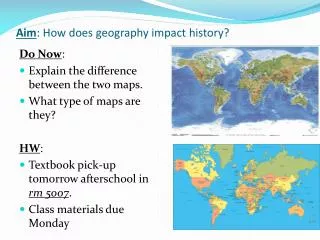
What are maps & what are they used for?. Early mental maps are egocentric. Where would you like to live?. The geocentric map concept. Based on: four cardinal directions angles and distances. Directions to campus

E N D
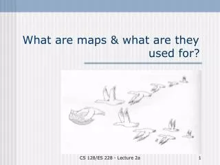
What are maps & what are they used for? CS 128/ES 228 - Lecture 2a
Early mental maps are egocentric CS 128/ES 228 - Lecture 2a
Where would you like to live? CS 128/ES 228 - Lecture 2a
The geocentric map concept Based on: • four cardinal directions • angles and distances • Directions to campus • It is easiest to approach campus from Route 17 (now called I-86). Take exit 24 (marked "Allegany - St. Bonaventure University"). At the end of the ramp, turn south (left if coming from Rt. 17 West, right if from Rt. 17 East). Drive about 1/2 mile to a "tee". • At the tee, turn left onto Route 417. Drive just over 2 miles, through the village of Allegany and across a high bridge over railroad tracks. Campus is visible to the right. • Immediately at the end of the bridge take the first right onto College Road (if you get to the traffic light, you've gone slightly too far. Turn around and return to College Road). Take the second left into a the parking lot marked at the bottom of the map. CS 128/ES 228 - Lecture 2a
What is a map? • “Art is a lie which makes us realize the truth.” P. Picasso • “So is a map.” P. Muehrcke(Map Use. 2nd ed. 1986) • “A map is a spatial model, an attempt to depict selected aspects of a geographic region on a flat plane.” T. Georgian CS 128/ES 228 - Lecture 2a
Warning!!! “Map and reality are not, cannot be identical. No aspect of map use is so obvious yet so often overlooked. Most map reading mistakes occur because the user forgets this vital fact and expects a one-to-one correspondence between map and reality.” P. Muehrcke Map Use (p. 19) CS 128/ES 228 - Lecture 2a
How does a map differ from reality? • Size • Dimensionality • Amount of detail • Symbolic presentation • Static vs. dynamic • ??? CS 128/ES 228 - Lecture 2a
What about aerial photographs? Aren’t they equivalent to reality? CS 128/ES 228 - Lecture 2a
Cartography: the art & science of creating maps CS 128/ES 228 - Lecture 2a
Selection Simplification Exaggeration Symbolization See textbook, Box 2.3 (p. 27) for a different list 4 steps of cartography: For my part of this course, learn outlines!! CS 128/ES 228 - Lecture 2a
1. Selection Depends on: • Purpose • Data availability • Size and scale of map CS 128/ES 228 - Lecture 2a
Selection: scale • One of the most important choices – determines what can or cannot be included in the map (Where’s SBU?) CS 128/ES 228 - Lecture 2a
Representing a map’s scale • Scale ratio ex. 1:24,000 • Verbal scale ex. 1 inch equals 2000 feet (often used with mixed units) • Coverage ex. 7 ½ minute topographic quadrangle • Scale line ex. CS 128/ES 228 - Lecture 2a
Large and small scales Large scale: • Scale ratio is a large fraction • a given feature looks large Small scale: • Scale ratio is a small fraction • a given feature looks small CS 128/ES 228 - Lecture 2a
The dilemma of scale • Small scale maps lack detailLarge scale maps lack range (coverage) • The dilemma can be alleviated somewhat by: - locator maps-- - inset maps CS 128/ES 228 - Lecture 2a
Inset maps Great invention, but: • User must dealwith multiplescales • Rule: the insetalways ends justshort of the point of interest CS 128/ES 228 - Lecture 2a
Selection: coverage • State maps minimize details in adjacent states • Topographic maps omit detail in urban areas CS 128/ES 228 - Lecture 2a
Selection: time frame • Maps are essentially snapshots • Two rules:1. Every map should be dated!! 2. Don’t trust the dates CS 128/ES 228 - Lecture 2a
2. Simplification Begins with choice of scale Other issues: • Reduced dimensionality of line or area features • Smoothing lines and boundaries • Aggregation CS 128/ES 228 - Lecture 2a
Reduced dimensionality CS 128/ES 228 - Lecture 2a
Smoothing lines and boundaries The blues lines are from a digitized U.S.G.S. 7 ½ min. topographic map. Note how the channel of Fourmile Creek been smoothed. CS 128/ES 228 - Lecture 2a
Aggregation • Like smoothing, but refers to scale of spacing of objects • Depends not only on scale but also on purpose of map CS 128/ES 228 - Lecture 2a
3. Exaggeration Why, given scale limitations, would map makers make features or labels larger? • Make symbols visible • Separate features and symbols CS 128/ES 228 - Lecture 2a
3. Exaggeration Exaggeration also reflects a map’s purpose Saul Steinberg’s Mar. 29, 1976 cover of the New Yorker magazine http://www.totalmedia.com/images/Newyorker.jpg CS 128/ES 228 - Lecture 2a
4. Symbolization • Size, texture, and density CS 128/ES 228 - Lecture 2a
Issues of Symbolization • Size, texture, and density Which symbols are emphasized on this map? Why? CS 128/ES 228 - Lecture 2a
Issues of Symbolization • Size, texture, and density http://blogjunky.blogspot.com/populationmap.gif http://www.atsdr.cdc.gov/HEC/HSPH/v5n21.jpg CS 128/ES 228 - Lecture 2a
Issues of Symbolization • Use of color CS 128/ES 228 - Lecture 2a
Issues of Symbolization • Realistic vs. abstract CS 128/ES 228 - Lecture 2a
Symbolization What decisions does this map reveal about: • Size, texture, and density • Use of color • Realistic vs. abstract symbols CS 128/ES 228 - Lecture 2a