Download
1 / 65
770 likes | 1.12k Views
Explore the multidisciplinary field of Fluvial Geomorphology, its influence on floodplain ecosystems, sediment transport, and stream channel restoration practices. Understand macro-to micro-geomorphology and hydraulic processes impacting rivers.

E N D
Fluvial Geomorphology Prof. Dr. Paul J. DuBowy Ecohydrology Associates, LLC Lovell, Wyoming 82431 USA ecohydrology.associates@gmail.com
Geomorphologic Concepts and Terms Consequences to Floodplain Ecosystems Biogeochemistry/Redox Reactions Hydric Soils Vegetation Zonation Outline
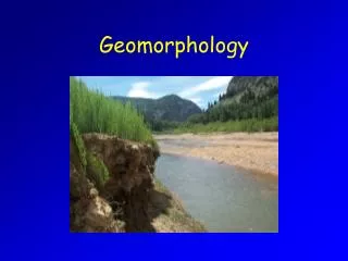
Much recent attention has focused on “natural stream channel design” = Fluvial Geomorphology. While this scientific discipline was relatively unknown as an applied science until recent years, recent application of the science to restoration designs shows a great deal of promise for effective stream channel management. Many years of extensive research in stream function and the factors that influence stream channel stability provide the backbone for application of this science. Fluvial Geomorphology
While some aspects of the discipline are unique, it is truly a multidisciplinary field, which requires knowledge of engineering, geology, biology, hydrology, soil science, and other scientific disciplines. Fluvial Geomorphology, taken literally, means the study of river-related landforms. Direct application of the science to stream channel restoration. Sediment transport, stable channel forms, hydraulic structure, stream channel assessment, and design practices. Fluvial Geomorphology 2
Balance of Dynamic Forces Rosgen Rosgen (Sediment Load) × (Sediment Size) ∝ (Stream Slope) × (Stream Discharge)
Head Cutting Erosion Long-term storage Sediment transfer Upland Upland valley Floodplain valley Large river Erosion Erosion/deposition (aggradation/degradation) Deposition from Church 2002
Effects of Slope Steeply sloped rivers will push a flood wave through the watershed more rapidly, creating a higher magnitude event with shorter duration (red hydrograph). Gently sloped rivers will move a flood wave through the watershed more slowly, creating a lower magnitude event with longer duration (blue hydrograph).
Effects of River Length Shorter rivers will push a flood wave through watershed more rapidly, creating a higher magnitude event with shorter duration (blue hydrograph). Longer rivers will move a flood wave through watershed more slowly, creating a lower magnitude event with longer duration (red hydrograph).
Effects of Roughness Low roughness rivers will allow a flood wave to travel through river more rapidly, creating a higher magnitude event with shorter duration (blue hydrograph). High roughness rivers will cause a flood wave to travel through watershed more slowly, creating a lower magnitude event with longer duration (red hydrograph).
Alluvium Lacustrine Deposits Marine Sediments Beach Deposits Material Moved/Deposited by Water
Consists of sediment deposited by running water along many old established streams lie a whole series of alluvial deposits in terraces—young deposits in the normally flooded bottom land of existing streams, up step by step to the very old deposits on highest terraces remnants of very old stream terraces may be found in dissected country far from any present stream in some places recent alluvium covers older terraces typical ridge and swale topography Alluvium
Watershed Geomorphology • River basins can be delineated into three distinct regions with different hydraulic drivers and geomorphic processes • Headwaters (erosion) • Floodplains (aggradation/degradation) • Deltas (deposition)
Sediment Behaviour Erosion Long-term storage Sediment transfer Upland Upland valley Floodplain valley Large river Erosion Erosion/deposition (aggradation/degradation) Deposition from Church 2002
Hydraulic Processes • It is in those low-gradiant floodplain reaches where we observe dynamic processes such as island and sandbar development and side channel and chute creation due to the continual removal and settling of alluvial material. • Islands, sandbars and paleochannels are not static – alluvium is continually reworked by hydraulic processes and moved downstream, leading to temporal patterns of channel morphology.
In order to understand wetland soils, we need to know something about: sediment type/origin organic material hydrology/inundation soil drainage/water flux biogeochemical redox reactions soil color Wetland Soils
Backwater deposits of fine sediments deposited between natural levees and along valley walls Terraces are earlier floodplains that may have been formed by river’s alluvial deposits, but are not connected hydrologically with present river (except during high floods) Low topographic relief deceptive elevation change of few centimeters may produce quite different hydrologic conditions, soils, and plant communities Floodplain Features
Condition that the soil area is covered by liquid free water Flooding is temporary inundation by flowing (overbank flow) water If the water is standing, as in a closed depression (precipitation, sheet wash, etc.), the term ponding is used Inundation Classes
Classes/Criteria None (N): No reasonable possibility Rare (R): 1 to 5 times in 100 years Occasional (O): 5 to 50 times in 100 years Frequent (F): > 50 times in 100 years Common (C): Occasional and frequent can be grouped for certain purposes and called common Frequency of Inundation
Classes/Criteria Extremely Brief (BE): < 4 hours Very Brief (BV): 4 to 48 hours Brief (B): 2 to 7 days Long (L): 7 days to 1 month Very Long (LV): > 1 month Duration of Inundation
Refers to the frequency and duration of wet periods under conditions similar to those under which the soil developed alteration of the water regime by humans, either through drainage or irrigation, is not a consideration unless the alterations have significantly changed the morphology of soil Natural Drainage Classes
Excessively Drained water is removed from soil very rapidly occurrence of internal free water commonly is very rare or very deep soils are commonly coarse-textured and have very high hydraulic conductivity or are very shallow Somewhat Excessively Drained water is removed from the soil rapidly internal free water occurrence commonly is very rare or very deep soils are commonly coarse-textured and have high saturated hydraulic conductivity or are very shallow Natural Drainage Classes
Well Drained water is removed from soil readily but not rapidly internal free water occurrence commonly is deep or very deep; annual duration is not specified water is available to plants throughout most of the growing season in humid regions wetness does not inhibit growth of roots for significant periods during most growing seasons soils are mainly free of deep or redoximorphic features that are related to wetness Natural Drainage Classes
Moderately Well Drained water is removed from the soil somewhat slowly during some periods of the year internal free water occurrence commonly is moderately deep and transitory through permanent soils are wet for only a short time within the rooting depth during the growing season, but long enough that most mesophytic crops are affected commonly have a moderately low or lower saturated hydraulic conductivity in a layer within the upper 1 m, periodically receive high rainfall, or both Natural Drainage Classes
Somewhat Poorly Drained water is removed slowly so that soil is wet at a shallow depth for significant periods during the growing season occurrence of internal free water commonly is shallow to moderately deep and transitory to permanent wetness markedly restricts growth of mesophytic crops, unless artificial drainage is provided soils commonly have one or more of following characteristics: low or very low saturated hydraulic conductivity, a high water table, additional water from seepage, or nearly continuous rainfall Natural Drainage Classes
Poorly Drained water is removed so slowly that the soil is wet at shallow depths periodically during the growing season or remains wet for long periods occurrence of internal free water is shallow or very shallow and common or persistent free water is commonly at or near the surface long enough during the growing season so that most mesophytic crops cannot be grown, unless the soil is artificially drained the soil, however, is not continuously wet directly below plow-depth free water at shallow depth is usually present this water table is commonly the result of low or very low saturated hydraulic conductivity of nearly continuous rainfall, or of a combination of these Natural Drainage Classes
Very Poorly Drained water is removed from soil so slowly that free water remains at or very near the ground surface during much of the growing season occurrence of internal free water is very shallow and persistent or permanent unless soil is artificially drained, most mesophytic crops cannot be grown soils are commonly level or depressed and frequently ponded if rainfall is high or nearly continuous, slope gradients may be greater Natural Drainage Classes
General Hypothesis: Spatial patterns of soil morphology can be explained by hillslope hydrology well-drained to poorly-drained/water-logged soils Removals Additions Alterations Effects on Wetland Soils
Accumulates in wet places where it is deposited more rapidly than it decomposes (or is removed) these deposits are called peat this peat in turn may become parent material for soils Organic Material
According to origin: Sedimentary peat remains mostly of floating aquatic plants, such as algae, and remains and fecal material of aquatic animals, including coprogenous earth Mossy peat remains of mosses, including Sphagnum Herbaceous peat remains of sedges, reeds, cattails, and other herbaceous plants Woody peat remains of trees, shrubs, and other woody plants Kinds of Peat
Many deposits of organic material are mixtures of peat Some organic soils formed in alternating layers of different kinds of peat In places peat is mixed with deposits of mineral alluvium and/or volcanic ash Some organic soils contain layers that are largely or entirely mineral material Organic Material
In describing organic soils, the material is called peat (fibric) if virtually all of the organic remains are sufficiently fresh and intact to permit identification of plant forms Called muck (sapric) if virtually all of the material has undergone sufficient decomposition to limit recognition of plant parts Called mucky peat (hemic) if a significant part of the material can be recognized and a significant part cannot Organic Material
Deposits consist of material that has settled out of bodies of still water unlike ridge and swale topography, ancient lake deposits are generally flat deposits laid down in fresh-water lakes associated directly with glaciers are commonly included as are other lake deposits, including some of Pleistocene age that are not associated with the continental glaciers some lake basins in the western United States (playas) have soils that may be more or less salty, depending on climate and drainage Lacustrine Deposits
Sediments settled out of the sea commonly were reworked by currents and tides later exposed either naturally or following construction of dikes and drainage canals vary widely in composition; some resemble lacustrine deposits, others more coarse Marine Sediments
Mark the present or former shorelines of the sea or lakes deposits are low ridges of sorted material and are commonly sandy, gravelly, cobbly, or stony these ridges are usually above the water table and, hence, generally do not contribute directly to wetland soils deposits on the beaches of former glacial lakes are usually included with glacial drift Beach Deposits
Soil Texture coupled with elevation gradients Biogeochemistry hydric soils Vegetation Responses Ecosystem Consequences
Floodwaters and subsequent groundwater levels determine type and productivity of vegetation in floodplain Hydroperiod (flooding duration, intensity, timing) limits plant species composition and influences ecosystem structure and function import nutrient-rich sediments to floodplain export organic and inorganic material timing important flooding in growing season has greater effect on species survival and ecosystem productivity Hydrologic Regime