Download
1 / 25
250 likes | 264 Views
Non-profit project to preserve natural resources & heritage, create sustainable development plan for fast-growing region.<br>

E N D
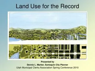
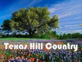
Current Land-Use and Development Database for the Texas Hill Country
Project Manager Aja Davidson Assistant Project Manager Clint Carpenter Web Master Jan Schneider GIS Developers Wesley Poehlmann Derek Smith
Texas Hill country alliance • Non-profit organization whose purpose is to preserve the natural resources and heritage of the Central Texas Hill Country. • Raise public awareness • Build community support • Focuses on seventeen counties. • Formed in response to escalating challenges brought by rapid development. • Resource for elected officials at state and local levels. • Collaborate with land trusts, groundwater districts, government groups and landowners.
Texas Hill Country • One of the fastest growing regions in the country • Popular tourist destination • Currently no comprehensive sustainable development plan • Political Boundaries often do not follow environmental boundaries. • An updatable and expandable geodatabase is needed in order to further the purpose of public and private participation in sustainable development. Introduction
Austin City Connection “2003 Land Use Inventory Overview and Methodology” • Jagadish, K.S. Sudhira, H.S. and Ramachandra, T.V., “Urban Sprawl Recognition and Modeling Using GIS” • Fitzpatrick, T., “Sharing Interactive Maps” • City of Chicago Department of Zoning, Interactive Map. Literature review
ESRI • TCEQ • TWDB • U.S. Census Bureau • City of Chicago Zoning Department • Medina County Appraisal District • Gillespie County Appraisal District Data Sources • Bexar County Information Services • Kerr County Central Appraisal District • Kendall County 911 Addressing • Comal County Engineers Office • Comal County Subdivision Regulation Department • Hays County GIS/911 Addressing Division • Bandera GIS operator • Austin City Connection • Burnet County City Planner
HCA Counties • Federal Lands • Cities • Railroads • Rail terminals • Water • Sewer • City limits Data • Groundwater Conservation Districts • Municipal Utility Districts • Parks • Census Block Groups • Parcel data: Medina, Bexar, Kerr, Kendall, Comal, Hays, Bandera, Travis, Gillespie and Burnet
All layers were projected in: NAD 1983 GCS UTM Zone 14N • Metadata Metadata updated to help the understanding, use, and management of the data we obtained. Data Description
ArcGIS Suite 9.2 • Macromedia Dreamweaver • Smart FTP • Manifold Software Used
Acquired Layers covering all counties • Acquired County by County layers such as parcels, ETJs and Subdivisions. Various other data was acquired but not used in project due to irrelevance. • Combined data with aquaKESKA into one database for the Manifold IMS, which was then linked to our individual group websites.http://geo-305577.evans.txstate.edu/HCA/default.asp Results
We were able to acquire parcel data for 10 of the 17 counties, these counties are: Results Continued
Cannot guarantee quality, content, accuracy or completeness of information. • HCA retains right to change content on website • Data should not be used for professional advice • TerraCorps, aquaKESKA and HCA assume no liability for misuse of data. Liability disclaimer
How Does This Relate to You? Source: http://chinese.faluninfo.net/images/evil%20guy%20pointing.JPG
Data acquisition: • Difficulty to contacting individuals • Encountered disinterest and apathy • Suspicion • Lack of digitized data • Amount of useless data • Accuracy and Completeness of Data Discussion
The IMS • No pan feature • Place and feature names not displayed • All layers selected at start up • Search operation nonfunctional • Menu doesn’t scroll Discussion continued
This project is unique in that nothing of this kind has been done for this size study area. All of the data collected has been available, but has never been compiled in this way. Hopefully this will encourage other students and professionals to follow suit and expand upon the idea of public participation. Discussion Continued
Detailed final report which includes an interactive website • Professional display poster • Project website containing: PowerPoint presentation Project documents Related links • CD containing: All data Proposal Progress Report Digital Copy of Poster in PDF format Final Paper Final Presentation Final Deliverables
What we gained by doing this project: • Communication skills • An awareness of the region • New knowledge of government hierarchy structure. • An appreciation for good time management skills. Conclusion
Help the Hill Country Alliance preserve the uniqueness of the Hill Country • Help encourage responsible growth and development. • Encourage use and development of GIS in county and city governments. Conclusion Continued
Any questions? Comments? Concerns? Q&a