Download
1 / 18
180 likes | 312 Views
Chemical Hydrogeology of the Hill Country, Texas. Megan Andring 11/20/2008. Study Area. Problem Definition. Zone of high SO 4 in well water Why is SO 4 distributed linearly? How can GIS be used to analyze this problem?. Travis. Gillespie. Blanco. Hays. Kerr. Kendall. Comal.

E N D
Chemical Hydrogeology of the Hill Country, Texas Megan Andring 11/20/2008
Problem Definition • Zone of high SO4 in well water • Why is SO4 distributed linearly? • How can GIS be used to analyze this problem? Travis Gillespie Blanco Hays Kerr Kendall Comal Bandera Bexar Medina
Data & Approach • Use TX well data • Analyze trends in chemistry • Look for spatial trends
Central Texas Geology • Mostly Cretaceous limestone and evaporites • Gypsum: CaSO4 • Calcite: CaCO3 • Halite: NaCl
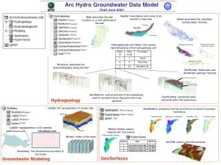
Methods: Well Data • Join chemical data for wells to spatial data
Results: Trends in Chemistry • Separate wells by geologic unit
Results: Spatial Trends • Compare SO4 distribution with elevation
Results: Spatial Trends • Compare SO4 distribution with elevation
Results: Spatial Trends • Compare SO4 distribution with elevation
Summary of Findings • SO4concentrated in Glen Rose & related formations • Highest SO4concentrations found on interfluves
Future Work • Compare locations of known gypsum layers in Glen Rose Fmn. with well data • Delineate watersheds using ArcHydro & compare with SO4 distribution
Data Sources & Acknowledgements • Texas Water Development Board • Texas Commission on Environmental Quality • Texas Natural Resources Information System • Ron Fieseler, Groundwater District Manager, Blanco County • Dr. Phil Bennett, Jackson School of Geosciences