Download
1 / 21
210 likes | 393 Views
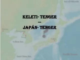
Keleti- tenger — Japán- tenger. Előadás sorrendje. Bevezetés Általános információ a tengerrészről Korea és Japán álláspontjai Melyik név a régebbi keletkezésű? Elnevezési módszerek (+ név kettőssége) Melyiket használják többen? Szervezetek szerepe (IHO és ENSZ) Mai helyzet

E N D
Előadás sorrendje • Bevezetés • Általános információ a tengerrészről • Korea és Japán álláspontjai • Melyik név a régebbi keletkezésű? • Elnevezési módszerek (+ név kettőssége) • Melyiket használják többen? • Szervezetek szerepe (IHO és ENSZ) • Mai helyzet • Magyarország véleménye
Téma • A koreaiak nemzeti sérelme • 1992.első felszólalás • Japán tiltakozás • Kompromisszum: kettős névhasználat • Megoldás?
Adatok • Beltenger • Koreai-félsziget, Japán, Oroszország • >1millió km2 • Mélység: ~4000m • Koreai szigetek: 독도, 울릉도 • Földgáz, halászat • Elnevezések: • Japán-tenger 日本海, Японскоеморе • Keleti-tenger 동해 • Koreai Keleti-tengernek 조선동해
Korea érvei • Keleti-tenger: 2000 éve használják • 삼국사기Kr.e.37. • 광개토왕 emlékműve i.sz. 414. • 1531. Korea nyolc tartományának térképe
Korea érvei • Keleti-tenger: 2000 éve használják • 삼국사기Kr.e.37. • 광개토왕 emlékműve i.sz. 414. • 1531. Korea nyolc tartományának térképe • Koreai-tenger (Sea of Joseon): • Japán, portugál, francia, angol térképek
1615 portugál térkép Takahashi K. 1809
Japán érvei • 17.sz. eleje: MatteoRicci – Mappa Mundi/KunyuWanguoQuantu • 17- 18.sz.: különböző elnevezések (Kína- tenger, Keleti- tenger, Keleti Óceán, Korea- tenger, Japán- tenger) • 18- 19.sz.: több kutató is vizsgálja a területet (Jean La Péreouse (fr.), William R. Broughton (ang.), Adam J. von Krusenstern (orosz)) Japán- tenger, mint név megalapítása • 1854: Japán izolációjának megszűnése
1602 日本海 MatteoRicci: KunyuWanguoQuantu, Peking A legrégibb ismert térkép, amely használja a Japán- tenger elnevezést. 1803 Mer du Japon
Névadási módszerek • Az kontinenstől keletre található. • Legtöbbet használt módszer: arról a földrészről, szigetről elnevezni a tengeri területet, amely elválasztja a tengert az óceántól(pl. Andamán- tenger, Kaliforniai- öböl, Ír- tenger) objektív módszer
Tanulmányok • Korea: nő a kettős névhasználat • 2000: 2,8% • 2005: 10,8% • 2007:23,8% • 2009:28,07% • Japán: a Japán-tenger a nemzetközileg elfogadott • 97%: csak Japán-tenger • 0 %: csak Keleti- tenger • Kevés: mindkét név
IHO • 1921. Nemzetközi Vízrajzi Szervezet (International HydrographicOrganization) • Japán:1921—Korea:1957 • 1929: Óceánok és tengerek határai c. kiadvány • 1937:2.kiadás • 1953:3.kiadás
1974-es határozat „It is recommended that where two or more countries share a given geographical feature (such as a bay, a strait, channel or archipelago) under different names, they should endeavor to reach agreement on a single name for the feature concerned. If they have different official languages and cannot agree on a common name form, it is recommended that the name forms of each of the languages in question should be accepted for charts and publications unless technical reasons prevent this practice on small scale charts.”
ENSZ • Japán: 1956—Korea: 1991 • 1977-es határozat:"when countries sharing a given geographical feature do not agree on a common name, it should be a general rule of cartography that the name used by each of the countries concerned will be accepted. A policy of accepting only one or some of such names while excluding the rest would be inconsistent as well as inexpedient in practice." • 1992: Korea első felvetése a név megváltoztatására • 1998, 2002
ENSZ • 2004: Japán-tenger név használata hivatalos dokumentumokban • Korea: „Japán helytelen érve”— nem az ENSZ álláspontja "The use of an appellation by the Secretariat based on the practice is without prejudice to any negotiations or agreements between the interested parties and should not be interpreted as advocating or endorsing any party's position, and can in no way be invoked by any party in support of a particular position in the matter."
Mai helyzet • KHOA:Korea Hydrographic and OceanographicAdministration • Japán-tenger név téves használata • „The words "EastSea" areinthefirst verse of ournationalanthem!” 동해 물과 백두산이 마르고 닳도록하느님이 보우하사 우리나라 만세 • http://eastsea.khoa.go.kr/eng/ • Tajvan, National Geographic, La Hora
Mai helyzet • 2011.augusztus 9. Chosunilbo: USA Japán-tenger név támogatása • Óceánok és tengerek határai 4.kiadására • Aug.13: Korea Focus • Aug.15.김성환: Koreai-tenger? • 2006: Béke vagy Barátság-tenger
Magyar álláspont • 2002.a Földrajzinév-bizottság 44/419.határozatában elutasította a Keleti-tenger név használatát • 2010. 73/674.határozatában elfogadta a Keleti-tengert névváltozatként, zárójelben