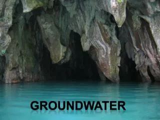
Groundwater
Groundwater. Dr. R. B. Schultz. Groundwater Groundwater is water, which originates from the infiltration of fluids through the soil profile and accumulates below the earth's surface in a porous layer.

Groundwater
E N D
Presentation Transcript
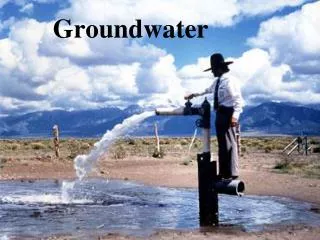
Groundwater Dr. R. B. Schultz
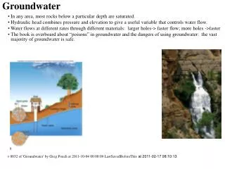
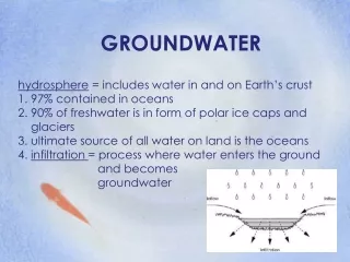
Groundwater Groundwater is water, which originates from the infiltration of fluids through the soil profile and accumulates below the earth's surface in a porous layer. Porosity is the percentage of open void space in the subsurface material. It is expressed as a percent. Permeability is how readily a fluid can flow through a material. Often referred to as "connected pore space". Pieziometric surface is the surface in which water is pushed up to by the pressure below. Spring is where water flows out without the aid of pumping. It may be caused by hydrostatic pressure (pressure pushing upward), or the intersection of the pieziometric surface with the ground surface. Also referred to as an Artesian System. An aquiferis the porous unit or layer of rock that is able to store or hold water and transmit enough fluid to be of economic value. An aquitardis rock material that is low in porosity/permeability. Fluid flow is not good and the unit may often be termed a "cap rock", not allowing underlying water to flow upward. An aquiclude is a unit of rock or layer of rock, which is impermeable to fluids. It acts as a barrier to fluid flow. There probably are no true aquicludes. There are two (2) scenarios that may occur with aquifers: 1.Confined Aquifer -- when an aquifer is bounded by two (2) aquitards (one above and one below) 2.Unconfined Aquifer -- when an aquifer is not bounded on the surface side by an aquitard so that fluids may flow freely above the aquifer. The distribution of groundwater is present in several distinct layers or zones: a.Soil moisture zone -- usually top soil; much infiltration; much organic material b.Zone of aeration (Vadose Zone) -- mostly air but some interstitial water c.Capillary fringe -- transition between unsaturated and saturated zone; top of aquifer d.Zone of saturation (Phreatic Zone) -- pores completely saturated with water; main aquifer storage zone Where does water in the ground originate? Hydrologic Cycle explains the origin of groundwater. Depicts the occurrence and movement of water in the earth-atmosphere system. Water enters the GW system at recharge areas. Water leaves GW system at discharge areas. Occurrence of water 1.97% of all water on earth is in oceans. 2.~ 2% of the earth's water in ice caps & glaciers 3.About 0.6% of earth's water is groundwater 4. Water in rivers, lakes, and the atmosphere amounts to less than 0.02% of earth's water Movement of Water Atmosphere to surface: precipitation Surface to atmosphere: evaporation -- liquid to vapor Sublimation -- solid to vapor Transpiration -- release of water vapor by plants On surface: downslope movement to lakes, streams, and oceans Below surface: movement of groundwater If GW seeps into stream, stream is a gaining stream. If water seeps from stream into subsurface, it is a losing stream. In areas in which soluble rock (i.e., limestone) is present in the layer near the groundwater, a situation often develops that is characterized by rock layer dissolving. This is referred to as karst topography. Indiana, Kentucky, and Georgia are areas in which karst topography may develop. The area is characterized by: a.Soluble bedrock near the surface b.Disappearing streams that feed downward with no end on the surface c.Sinkholes d.Patchy, pockmarked surface topography e.Frequent fluctuations in water table f.Caves g.Submerged caves Caves are formed by the dissolving nature of the rock fed by groundwater. Large cavities develop as well as solid drops of rock that precipitate from the groundwater solution. Those overhead are called stalactites (stick tight to the ceiling) and those that build up from the ground floor are termed stalagmites (with a ''g''). There are several problems, which can develop, associated with the lowering of the groundwater surface due to overuse/over pumping: 1.Cone of depression develops 2.Lowering of the pieziometric surface, thus wells dry up 3.Saltwater incursion/intrusion if near an ocean Groundwater Contamination Contamination results in a decline in water quality. Common contaminants: TypesSources Nitrates Sewage, Fertilizers, Feedlots Pesticides, herbicides Agriculture, lawn care Organic chemicals Industrial wastes, landfills, spills/leaks of fuels Metals Industrial processes Brines Oil production Protecting groundwater resources Apply agricultural chemicals properly Build better landfills Regulate disposal of hazardous materials Regulate underground storage tanks (USTs) Limit contaminant levels in drinking water supplies. Companies often employ environmental consulting firms and individuals to better understand environmental problems and seek solutions for the challenges.
An aquicludeis a unit of rock or layer of rock, which is impermeable to fluids. It acts as a barrier to fluid flow. There probably are no true aquicludes. There are two (2) scenarios that may occur with aquifers: 1.Confined Aquifer -- when an aquifer is bounded by two (2) aquitards (one above and one below) 2.Unconfined Aquifer -- when an aquifer is not bounded on the surface side by an aquitard so that fluids may flow freely above the aquifer. The distribution of groundwater is present in several distinct layers or zones: a.Soil moisture zone -- usually top soil; much infiltration; much organic material b.Zone of aeration(Vadose Zone) -- mostly air but some interstitial water c.Capillary fringe -- transition between unsaturated and saturated zone; top of aquifer d.Zone of saturation (Phreatic Zone) -- pores completely saturated with water; main aquifer storage zone Where does water in the ground originate? Hydrologic Cycle explains the origin of groundwater. Depicts the occurrence and movement of water in the earth-atmosphere system. Water enters the GW system at recharge areas. Water leaves GW system at discharge areas.
Occurrence of water 1.97% of all water on earth is in oceans. 2.~ 2% of the earth's water in ice caps & glaciers 3.About 0.6% of earth's water is groundwater Water in rivers, lakes, and the atmosphere amounts to less than 0.02% of earth's water Movement of Water Atmosphere to surface: precipitation Surface to atmosphere: evaporation -- liquid to vapor Sublimation-- solid to vapor Transpiration -- release of water vapor by plants On surface: downslope movement to lakes, streams, and oceans Below surface: movement of groundwater If GW seeps into stream, stream is a gaining stream. If water seeps from stream into subsurface, it is a losing stream.
Hydrologic Cycle Precipitation Precipitation Evaporation Runoff Infiltration
In areas in which soluble rock (i.e., limestone) is present in the layer near the groundwater, a situation often develops that is characterized by rock layer dissolving. This is referred to as karst topography. Indiana, Kentucky, and Georgia are areas in which karst topography may develop. The area is characterized by: • a.Soluble bedrock near the surface • b.Disappearing streams that feed downward with no end on the surface • c.Sinkholes • d.Patchy, pockmarked surface topography • e.Frequent fluctuations in water table • f.Caves • g.Submerged caves Caves are formed by the dissolving nature of the rock fed by groundwater. Large cavities develop as well as solid drops of rock that precipitate from the groundwater solution. Those overhead are called stalactites (stick tight to the ceiling) and those that build up from the ground floor are termed stalagmites (with a ''g'').
There are several problems, which can develop, associated with the lowering of the groundwater surface due to overuse/over pumping: • 1.Cone of depression develops • 2.Lowering of the pieziometric surface, thus wells dry up • 3.Saltwater incursion/intrusion if near an ocean Groundwater Contamination Contamination results in a decline in water quality. Common contaminants: TypesSources Nitrates Sewage, Fertilizers, Feedlots Pesticides, herbicides Agriculture, lawn care Organic chemicals Industrial wastes, landfills, spills/leaks of fuels Metals Industrial processes Brines Oil production Protecting groundwater resources • Apply agricultural chemicals properly • Build better landfills • Regulate disposal of hazardous materials • Regulate underground storage tanks (USTs) • Limit contaminant levels in drinking water supplies.
Key Terminology Groundwater Porosity Permeability Pieziometric surface Spring Artesian system Aquifer Aquitard Aquiclude Confined aquifer Unconfined aquifer Soil moisture zone Vadose zone Phreatic zone Zone of aeration Zone of saturation Capillary fringe Hydrologic cycle Recharge area Discharge area Precipitation Transpiration Evaporation Runoff Sublimation Gaining stream Losing stream Karst topography Stalagmites Stalactites Cone of depression Saltwater intrusion/incursion
Pertinent Web Sites About Geysers Good information, photos, and links related to geysers. Carlsbad Caverns National Park Home page of Carlsbad Caverns National Park. Cave Database World cave database sorted by depth, length, and country. Cave Links An extensive listing of cave links from the National Speleological Society. Caves and Karst Links (Houghton Mifflin) Links to several cave and karst sites, including class lecture notes, arranged by topic. Caves Directory Information on show caves in the United States. Caving Links Information on caving from the Great Outdoor Recreation Pages (GORP) site. Edwards Aquifer, Texas The Edwards aquifer in Texas is a unique groundwater system and one of the most prolific artesian aquifers in the world. Groundwater Calculations Online groundwater calculators from LMNO Engineering, Research, and Software, Ltd. Groundwater Foundation The Groundwater Foundation is dedicated to informing the public about one of our greatest hidden resources, groundwater.
Groundwater Issues and Resources Links to several groundwater and groundwater issue sites. Groundwater Links (Houghton Mifflin) Links to several groundwater sites, including class lecture notes, arranged by topic. Groundwater Links (NAGT) An extensive listing of groundwater links arranged by topic from the National Association of Geology Teachers (NAGT). Groundwater Primer A good basic introduction to groundwater from the Environmental Protection Agency (EPA). Karst Links This Central Michigan University site maintained by Dr. Mark Francek lists several good links to Web sites containing information relative to topics discussed in the chapter. National Ground Water Association The mission of the National Ground Water Association is to provide professional and technical leadership in the advancement of the ground water industry and in the protection, the promotion, and the responsible development and use of ground water resources. National Speleological Society (NSS) The NSS was founded for the purpose of advancing the study, conservation, exploration, and knowledge of caves. Understanding Groundwater Great information on how groundwater exists, where it exists, and how it moves. Virtual Cave The Virtual Cave has collected images from around the world and combined them to generate an 'ideal' cave—one that contains an example of every major type of speleothem, or secondary mineral deposit. Water Resource Terms (Glossary of) A glossary of water resource terms from the Edwards aquifer home page.